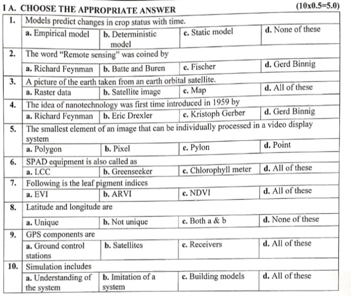
1. Models predict changes in crop status with time. 2. The word 'Remote sensing' was coined by. 3. A picture of the earth taken from an earth orbital satellite. 4. The idea of nano... 1. Models predict changes in crop status with time. 2. The word 'Remote sensing' was coined by. 3. A picture of the earth taken from an earth orbital satellite. 4. The idea of nanotechnology was first time introduced in 1959 by. 5. The smallest element of an image that can be individually processed in a video display system. 6. SPAD equipment is also called as. 7. Following is the leaf pigment indices. 8. Latitude and longitude are. 9. GPS components are. 10. Simulation includes.

Understand the Problem
The question presents a multiple-choice format quiz involving various topics related to models, remote sensing, and other concepts in science. The user is likely looking for answers to these questions.
Answer
1. b) Deterministic model; 2. a) Richard Feynman; 3. b) Satellite image; 4. a) Richard Feynman; 5. b) Pixel; 6. c) Chlorophyll meter; 7. b) ARVI; 8. b) Not unique; 9. d) All of these; 10. d) All of these
- b) Deterministic model; 2. a) Richard Feynman; 3. b) Satellite image; 4. a) Richard Feynman; 5. b) Pixel; 6. c) Chlorophyll meter; 7. b) ARVI; 8. b) Not unique; 9. d) All of these; 10. d) All of these
Answer for screen readers
- b) Deterministic model; 2. a) Richard Feynman; 3. b) Satellite image; 4. a) Richard Feynman; 5. b) Pixel; 6. c) Chlorophyll meter; 7. b) ARVI; 8. b) Not unique; 9. d) All of these; 10. d) All of these
More Information
Richard Feynman introduced the idea of nanotechnology in a famous talk titled 'There's Plenty of Room at the Bottom' in 1959. The smallest element of an image in a video display system is a pixel, which is short for 'picture element.'
Tips
Be careful about the context of technological terms; for example, 'remote sensing' and 'deterministic model' have specific meanings in the context of crop modeling and prediction.
Sources
- Contribution of Remote Sensing on Crop Models: A Review - MDPI - mdpi.com
- GEO-CropSim: A New Water Use and Crop Yield Simulator - appliedsciences.nasa.gov
- [PDF] defense advanced research projects agency - Darpa - darpa.mil
AI-generated content may contain errors. Please verify critical information