Podcast
Questions and Answers
What is the primary purpose of contour lines on a topographic map?
What is the primary purpose of contour lines on a topographic map?
- To show elevations and relief (correct)
- To indicate the location of landmarks
- To show the shape of the earth's surface
- To provide a graphical representation of the 3D shape of the earth's surface
What is the term for the height of an object above sea level?
What is the term for the height of an object above sea level?
- Slope
- Contour interval
- Relief
- Elevation (correct)
What is the function of an index contour on a topographic map?
What is the function of an index contour on a topographic map?
- To label the elevation of every fifth contour line (correct)
- To show the steepest slope
- To indicate the highest point on the map
- To separate adjacent contour lines
What is the term for the difference in elevation between the highest and lowest points on a topographic map?
What is the term for the difference in elevation between the highest and lowest points on a topographic map?
What is the significance of the spacing of contour lines on a topographic map?
What is the significance of the spacing of contour lines on a topographic map?
What are some of the real-world applications of topographic maps?
What are some of the real-world applications of topographic maps?
What do contour lines on a topographic map represent?
What do contour lines on a topographic map represent?
What is the purpose of the contour interval on a topographic map?
What is the purpose of the contour interval on a topographic map?
What is the significance of the color brown on a topographic map?
What is the significance of the color brown on a topographic map?
What can be inferred from closely spaced contour lines on a topographic map?
What can be inferred from closely spaced contour lines on a topographic map?
What is the purpose of an index contour on a topographic map?
What is the purpose of an index contour on a topographic map?
What can be studied using a topographic map?
What can be studied using a topographic map?
Flashcards are hidden until you start studying
Study Notes
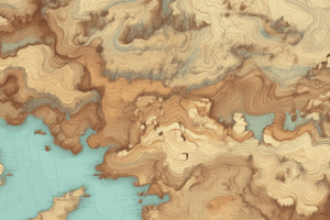
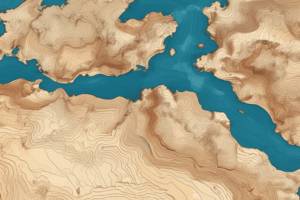
Topographic Maps
- A graphical representation of the 3D shape of the earth's surface, showing elevation and shape.
Elements of Elevation
- Contour: imaginary lines that join places having the same height above sea level, shown in brown color.
- Contour lines: used to show elevations.
- Contour interval: the vertical distance that separates every contour line on a topographic map.
Representation of Elevation
- Contour lines represent elevation on a topographic map.
- Spacing of contour lines indicates the steepness of the slope.
- Closely spaced contour lines indicate steep slopes, while widely spaced contour lines indicate gentle slopes.
Additional Information
- Elevation symbols and color coding provide additional information about elevation.
- Index contour: a darker, heavier contour line, usually every fifth line, labeled by elevation.
Landforms and Landscape
- Elevation, relief, and slope of different landforms influence the appearance and characteristics of the landscape.
- Relief: the difference in elevation between the highest and lowest point of the area being mapped.
Real-World Applications
- Topographic maps have real-world applications in land use planning, construction, and environmental studies.
- Examples of applications include:
- Land use planning
- Construction
- Environmental studies
Studying That Suits You
Use AI to generate personalized quizzes and flashcards to suit your learning preferences.