Podcast
Questions and Answers
What is the main purpose of a topographic map?
What is the main purpose of a topographic map?
- To illustrate the climate of a region
- To show the location of different types of rocks
- To display the elevation of an area (correct)
- To identify the location of natural disasters
What do contour lines on a topographic map represent?
What do contour lines on a topographic map represent?
- Points of different climate zones
- Points of different soil types
- Points of different types of rocks
- Points of equal elevation (correct)
Why are contour lines on a topographic map crooked?
Why are contour lines on a topographic map crooked?
- Because the map is outdated
- Because the map is not accurately drawn
- Because the elevation of the area is not uniform (correct)
- Because the map is not drawn to scale
What is the analogy used to explain contour lines in the lesson?
What is the analogy used to explain contour lines in the lesson?
What is the relationship between topographic maps and geologic maps?
What is the relationship between topographic maps and geologic maps?
What would be the shape of the path if you were to run around the base of a pyramid and then go up 10 feet to the first painted level of step and run around that?
What would be the shape of the path if you were to run around the base of a pyramid and then go up 10 feet to the first painted level of step and run around that?
What do hachures on a topographic map represent?
What do hachures on a topographic map represent?
What do the lines on a topographic map represent?
What do the lines on a topographic map represent?
What is the primary difference between a topographic map and a geologic map?
What is the primary difference between a topographic map and a geologic map?
What do the colors on a geologic map typically represent?
What do the colors on a geologic map typically represent?
Why do topographic maps not put numbers on every line?
Why do topographic maps not put numbers on every line?
What is the purpose of the key or legend on a geologic map?
What is the purpose of the key or legend on a geologic map?
What is the purpose of index contours on a topographic map?
What is the purpose of index contours on a topographic map?
Why do contour lines on a topographic map form circles around hills and depressions?
Why do contour lines on a topographic map form circles around hills and depressions?
What does the space between two contour lines on a topographic map represent?
What does the space between two contour lines on a topographic map represent?
Flashcards are hidden until you start studying
Study Notes
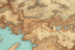
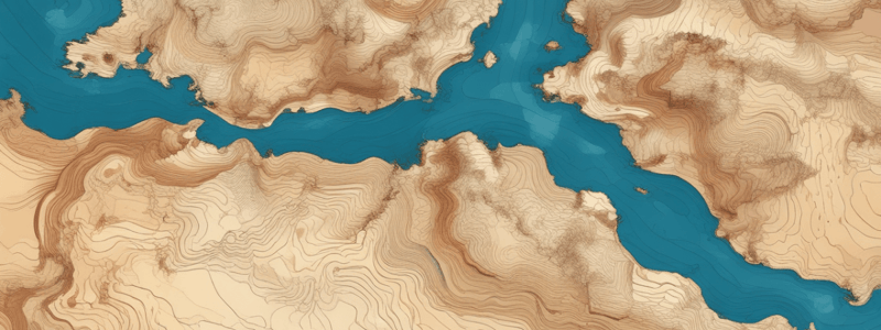
Topographic Maps
- A topographic map is a type of map that shows elevation.
- Topographic maps are used by people like hikers to know the elevation of an area.
Contour Lines
- Contour lines connect points of equal elevation.
- Contour lines are like the lines on a banana split, circling around the mountain peak.
- On a topographic map, contour lines are usually shown in a light brown color.
- Each contour line represents a different elevation.
Index Contours
- Index contours are contour lines with numbers on them.
- Index contours display the exact elevation of a specific line.
- Index contours are usually labeled only in two or three places to avoid clutter.
Contour Rules
- Contour lines cannot cross, as it would mean one location has two different elevations.
- Contour lines form circles around hills or depressions.
- The contour interval is the distance between two side-by-side lines.
- The closer the contour lines, the steeper the hill.
Hachures
- Hachures are small lines that show depressions or holes on a topographic map.
- Hachures look like teeth in an open mouth.
Geologic Maps
- A geologic map contains topographic lines and shows ages and types of rocks.
- Geologic maps show geologic features and have more information layered on top of the topographic map.
- Colors on a geologic map represent different types of rocks or ages of rocks.
- Black lines or markings on a geologic map are typically geologic markings.
Studying That Suits You
Use AI to generate personalized quizzes and flashcards to suit your learning preferences.