Podcast
Questions and Answers
What is the main reason why understanding maps is crucial in the digital age?
What is the main reason why understanding maps is crucial in the digital age?
- To rely solely on digital devices for navigation
- To be able to use 3-D software for map analysis
- To only use paper maps for navigation
- To have a backup when digital devices fail in remote areas (correct)
What is the primary function of digital devices in navigation?
What is the primary function of digital devices in navigation?
- To replace map reading skills with technology
- To interpret and think for the user (correct)
- To provide only 2-D spatial skills
- To provide 3-D visualization of maps
Why are map reading skills necessary in the digital age?
Why are map reading skills necessary in the digital age?
- Because digital devices can die or fail in remote areas (correct)
- Because digital devices can fully replace map reading skills
- Because maps are only used for hiking and geology
- Because digital devices are always reliable
What is the main objective of learning about maps?
What is the main objective of learning about maps?
What is a benefit of learning about maps?
What is a benefit of learning about maps?
What is a limitation of relying solely on digital devices for navigation?
What is a limitation of relying solely on digital devices for navigation?
What is a consequence of relying on digital devices for navigation?
What is a consequence of relying on digital devices for navigation?
What is the relationship between navigating technology and maps?
What is the relationship between navigating technology and maps?
What was the primary use of paper-based maps 20 years ago?
What was the primary use of paper-based maps 20 years ago?
What type of maps do geologists primarily use?
What type of maps do geologists primarily use?
What do contour lines on a topographic map represent?
What do contour lines on a topographic map represent?
What is used as the reference point for measuring elevation values on Earth?
What is used as the reference point for measuring elevation values on Earth?
What is the primary application of topographic maps aside from Geology?
What is the primary application of topographic maps aside from Geology?
What is the elevation of Regina above sea level?
What is the elevation of Regina above sea level?
What is the depth of the Marianas Trench below sea level?
What is the depth of the Marianas Trench below sea level?
What is the purpose of a contour line on a topographic map?
What is the purpose of a contour line on a topographic map?
What is the purpose of a north arrow on a map?
What is the purpose of a north arrow on a map?
What is the term used to describe the deep, narrow valleys found under the sea?
What is the term used to describe the deep, narrow valleys found under the sea?
What is the purpose of the map legend?
What is the purpose of the map legend?
What type of rocks are typically depicted on a map in hues of pink and/or red?
What type of rocks are typically depicted on a map in hues of pink and/or red?
What is the term used to describe the process of one tectonic plate being forced below another?
What is the term used to describe the process of one tectonic plate being forced below another?
What is the main difference between the relief above and below the sea level?
What is the main difference between the relief above and below the sea level?
What is the purpose of colours on a typical geographical or physical map?
What is the purpose of colours on a typical geographical or physical map?
What is the typical colour used to represent Cretaceous sediments on a geological map?
What is the typical colour used to represent Cretaceous sediments on a geological map?
Study Notes
Importance of Maps
- Maps are powerful instruments to understand the natural world and navigate from place to place.
- Understanding maps is a crucial skill for everyone, regardless of profession or hobby.
- Maps form the basis of material used in daily life, such as getting to class or finding the best route to travel.
Digital Age and Maps
- In the digital age, people are not often exposed to physical maps, but digital maps are based on them.
- Understanding basic paper maps is essential for working with digital platforms.
- Relying solely on digital devices can reduce visualization and spatial skills.
Map Elements
- A good map must contain essential elements, including:
- Symbols (explained in the map legend)
- Colors (used to represent different features, such as relief, bodies of water, and geological time scales)
- North direction (indicated by a north arrow)
Geological Maps
- Geological maps use standard symbols for common rock types.
- Colors on geological maps are often related to the geological time scale or the origin of rocks.
- Plutonic rocks are typically depicted in hues of pink and/or red.
Topographic Maps
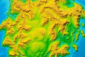
- Topographic maps show the relief or elevation of land surfaces using contour lines.
- Contour lines connect points on a map with the same elevation.
- Topographic maps display human-made and natural features, making them useful for various disciplines.
Contour Lines
- The difference in value between two adjacent contour lines is constant for each map.
- The value is specified in the map legend.
- Contour lines are essential for understanding the relief of land surfaces.
Studying That Suits You
Use AI to generate personalized quizzes and flashcards to suit your learning preferences.
Description
Learn about the elements of a good map, types of maps, and their importance in the digital age. Practice reading topographic maps and understanding contour, scales, and symbols.