Podcast
Questions and Answers
What shape would you get if you ran around the base of a pyramid?
What shape would you get if you ran around the base of a pyramid?
- Circle
- Rectangle
- Square (correct)
- Triangle
What is true about contour lines on hills and mountains?
What is true about contour lines on hills and mountains?
- They always get smaller as you go up in elevation (correct)
- They are only found on pyramids
- They never change as you go up in elevation
- They always get larger as you go up in elevation
What do hachures represent on a topographic map?
What do hachures represent on a topographic map?
- Cities and towns
- Mountains and hills
- Depressions or holes (correct)
- Rivers and lakes
What is a common feature of a geologic map?
What is a common feature of a geologic map?
What do black markings typically represent on a geologic map?
What do black markings typically represent on a geologic map?
What do different colors typically represent on a geologic map?
What do different colors typically represent on a geologic map?
What do reds and oranges usually represent on a geologic map?
What do reds and oranges usually represent on a geologic map?
What do patterns on a rock type typically indicate on a geologic map?
What do patterns on a rock type typically indicate on a geologic map?
What do pink rocks with circles on them on a geologic map typically represent?
What do pink rocks with circles on them on a geologic map typically represent?
What is the purpose of the key or legend on a geologic map?
What is the purpose of the key or legend on a geologic map?
Flashcards are hidden until you start studying
Study Notes
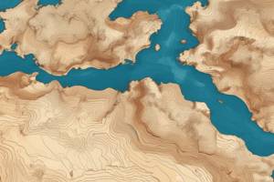
Topographic Maps
- A topographic map is a type of map that shows elevation and is used by people like hikers who need to know the elevation of an area.
- Topographic maps show contour lines, which connect points of equal elevation, similar to the lines on a banana split sundae.
- Contour lines on a map are typically shown in a light brown color.
Contour Lines
- Contour lines show elevation, with each line representing a different elevation.
- Index contours display the exact elevation of one specific line.
- Index contours are usually labeled in two or three places on the map to avoid clutter.
Contour Rules
- Contour lines cannot cross, as this would mean a location has two different elevations, which is not possible.
- Contour lines form circles around hills or depressions.
Contour Intervals
- The contour interval is the distance between any two side-by-side lines.
- For example, a contour interval of 10 means that each line represents a 10-foot elevation change.
Hills and Depressions
- Contour lines close around hills and depressions, forming concentric circles.
- Lines get closer together on steep hills and farther apart on gentle slopes.
Hachures
- Hachures are small lines that show depressions or holes on a topographic map.
- Hachures resemble teeth in an open mouth and indicate a dip or bowl shape in the landscape.
Geologic Maps
- Geologic maps are similar to topographic maps but include additional information, such as the age and type of rocks.
- Geologic maps show topographic lines, ages, and types of rocks.
- Colors on a geologic map represent different types of rocks or ages of rocks, with different colors used for igneous, metamorphic, and marine-formed rocks.
Studying That Suits You
Use AI to generate personalized quizzes and flashcards to suit your learning preferences.