Podcast
Questions and Answers
What are contour lines used for in topographic maps?
What are contour lines used for in topographic maps?
Contour lines are used to show the elevation of an area.
What are the rules for contour lines in topographic maps?
What are the rules for contour lines in topographic maps?
Contour lines cannot cross and they form circles around hills or depressions.
What does a topographic map show?
What does a topographic map show?
A topographic map shows elevation.
Who uses topographic maps?
Who uses topographic maps?
What do the lines on a topographic map represent?
What do the lines on a topographic map represent?
How do contour lines on a topographic map connect to a geologic map?
How do contour lines on a topographic map connect to a geologic map?
What are contour lines?
What are contour lines?
What is the purpose of index contours?
What is the purpose of index contours?
Why are numbers not put on every contour line?
Why are numbers not put on every contour line?
What is the contour interval?
What is the contour interval?
What does it mean if contour lines cross?
What does it mean if contour lines cross?
How does the closeness of contour lines relate to the steepness of a hill?
How does the closeness of contour lines relate to the steepness of a hill?
What are contour lines?
What are contour lines?
What do contour lines that have numbers on them represent?
What do contour lines that have numbers on them represent?
What is a contour interval?
What is a contour interval?
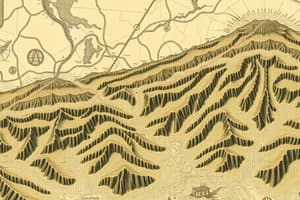
What are hachures?
What are hachures?
What additional information is shown on a geologic map compared to a topographic map?
What additional information is shown on a geologic map compared to a topographic map?
How are different types of rocks represented on a geologic map?
How are different types of rocks represented on a geologic map?
What do solid colors on a geologic map usually indicate?
What do solid colors on a geologic map usually indicate?
What does the key or legend on a map explain?
What does the key or legend on a map explain?
Flashcards are hidden until you start studying