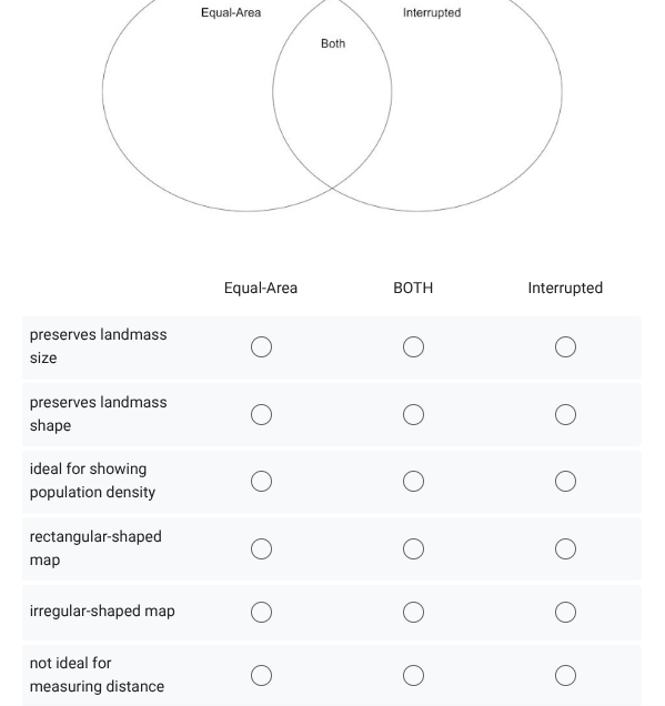
What are the characteristics of Equal-Area, Interrupted, and Both types of maps regarding landmass size, shape, and ideal uses?

Understand the Problem
The question is asking to classify characteristics of different types of maps (Equal-Area, Interrupted, and Both) based on their attributes such as landmass size, shape, and suitability for various purposes.
Answer
Equal-Area: preserves size, ideal for density. Interrupted: irregular map. Both: not ideal for measuring distance. Rectangular map: neither.
For equal-area maps: preserves landmass size, ideal for showing population density. For interrupted maps: irregular-shaped map. For both: not ideal for measuring distance. Rectangular-shaped map doesn't apply to either.
Answer for screen readers
For equal-area maps: preserves landmass size, ideal for showing population density. For interrupted maps: irregular-shaped map. For both: not ideal for measuring distance. Rectangular-shaped map doesn't apply to either.
More Information
Equal-area maps maintain accurate sizes but distort shapes, making them useful for statistical displays. Interrupted maps reduce shape distortion by breaking continuity, but lack usefulness for measuring distance.
Tips
A common mistake is assuming that interrupted projections preserve shape perfectly; they actually reduce distortion but still affect scale.
Sources
- Selecting a Map Projection - National Geographic Education - education.nationalgeographic.org
- Map Projections | Definition & Types - Lesson - Study.com - study.com
AI-generated content may contain errors. Please verify critical information