Podcast
Questions and Answers
Match the following features of Ethiopian topography with their descriptions:
Match the following features of Ethiopian topography with their descriptions:
Mount Ras Dashen = Highest mountain in Ethiopia at 4,620 m.a.s.l Kobar Sink = Lowest point in Ethiopia, 125 meters below sea level Ethiopian Highlands = Roof of East Africa with elevated landmass Rift Valley = Physiographic division characterized by great diversity
Match the following geological processes with their effects on Ethiopian topography:
Match the following geological processes with their effects on Ethiopian topography:
Faulting = Formation of structural valleys and depressions Geomorphic processes = Modification of landforms through river dissection Lava outpouring = Development of outward sloping highland plateaus River deposition = Creation of lakes in lower areas
Match the following altitudinal ranges with their corresponding percentages in Ethiopia:
Match the following altitudinal ranges with their corresponding percentages in Ethiopia:
Above 1,000 meters = More than 50% of Ethiopian landmass Above 1,500 meters = 44% of the country Above 2,000 meters = Half of the 1,500 meters range Below sea level = Kobar Sink at 125 meters below sea level
Match the following characteristics of Ethiopian physiography with their types:
Match the following characteristics of Ethiopian physiography with their types:
Match the following descriptions of the Ethiopian landmass with their implications:
Match the following descriptions of the Ethiopian landmass with their implications:
Match the following characteristics with their corresponding regions in Ethiopia:
Match the following characteristics with their corresponding regions in Ethiopia:
Match the physiographic divisions of Ethiopia with their descriptions:
Match the physiographic divisions of Ethiopia with their descriptions:
Match the following physiographic units with their respective coverage area percentages:
Match the following physiographic units with their respective coverage area percentages:
Match the following regions with their associated economic life:
Match the following regions with their associated economic life:
Match the following geographical features of Ethiopia with their characteristics:
Match the following geographical features of Ethiopia with their characteristics:
Flashcards
Ethiopian Highlands
Ethiopian Highlands
The largest continuous elevated region in Africa, also known as the "Roof of East Africa".
Ethiopian Topography
Ethiopian Topography
Shaped by Cenozoic Era geological activities creating highlands, mountains, and valleys.
Highland Rainfall
Highland Rainfall
Moderate to high annual rainfall (>600 mm) in Ethiopian highlands.
Ethiopian Lowlands
Ethiopian Lowlands
Signup and view all the flashcards
Physiographic Divisions
Physiographic Divisions
Signup and view all the flashcards
Western Highlands/Lowlands
Western Highlands/Lowlands
Signup and view all the flashcards
Tigray Plateau
Tigray Plateau
Signup and view all the flashcards
Altitude Range
Altitude Range
Signup and view all the flashcards
Population Density
Population Density
Signup and view all the flashcards
Irrigation Agriculture
Irrigation Agriculture
Signup and view all the flashcards
Study Notes
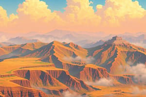
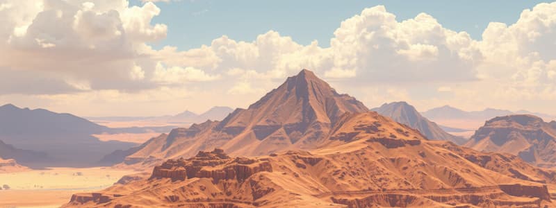
Topography of Ethiopia and the Horn
- Ethiopia's topography is shaped by Cenozoic Era geological activities, including the uplift of the Arabo-Ethiopian swell.
- Trapean lava outpouring has created a highland plateau with mountains and structural valleys, influenced by significant faulting.
- River courses were affected by faulting, leading to lake formations in depressions.
Ethiopian Physiography
- The landform features diverse terrains: flat-topped plateaus, rugged mountains, deep river gorges, and vast plains.
- Altitude ranges from 125 meters below sea level (Kobar Sink) to Mount Ras Dashen at 4,620 meters above sea level, the fourth highest peak in Africa.
- Over 50% of Ethiopia's landmass sits above 1,000 meters; 44% exceeds 1,500 meters, with a significant portion above 2,000 meters.
- The Ethiopian Highlands, crucial geographical features, comprise the largest continuous elevated region in Africa, known as the "Roof of East Africa."
Highland vs. Lowland Characteristics
- Ethiopian highlands experience moderate to high annual rainfall (>600 mm) and lower temperatures (average 22% below mean annual temperature at 2,000 m.a.s.l).
- Ethiopian lowlands (44% of the land) have less rainfall, higher temperatures, and higher prevalence of tropical diseases.
- Lowland areas exhibit lower population densities and nomadic or semi-nomadic lifestyles, contrasting with the more dense highland settlements.
- Vast plains in the lowlands support irrigation agriculture, primarily along river basins.
Physiographic Divisions of Ethiopia
- Three major physiographic units are identified due to geological faulting processes:
- Western highlands and lowlands
- South-eastern (Eastern) highlands and lowlands
- Rift Valley
Western Highlands and Lowlands
- This unit covers nearly the entire western half of Ethiopia, comprising about 44% of the country's area.
- Bounded by the eastern escarpment of the Rift Valley and descending toward Sudan in the west.
- Subdivided into four highland groups (76.3%) and four lowland groups (23.7%).
Tigray Plateau
- Located from the Tekeze gorge southward to the central Eritrean highlands, separated from the Eritrean plateau by the Mereb River.
Studying That Suits You
Use AI to generate personalized quizzes and flashcards to suit your learning preferences.