Podcast
Questions and Answers
Explain the primary purpose of the TCAS system, using multiple sentences. Explain how it functions to achieve that purpose.
Explain the primary purpose of the TCAS system, using multiple sentences. Explain how it functions to achieve that purpose.
The primary purpose of the TCAS system is to prevent aircraft from being involved in mid-air collisions. TCAS accomplishes this by using transponders on equipped aircraft that transmit and receive signals. Each TCAS-equipped aircraft interrogates all other nearby aircraft about their position, builds a three-dimensional map, and determines if a potential collision exists based on extrapolated positions.
Why is TCAS considered a more advanced safety system than primary surveillance radar (PSR)? How does TCAS address the limitations of PSR?
Why is TCAS considered a more advanced safety system than primary surveillance radar (PSR)? How does TCAS address the limitations of PSR?
TCAS is a more advanced safety system than PSR because it uses transponders to determine not only the position of aircraft, but also their altitude and identity, which are crucial pieces of information that PSR lacks. This makes TCAS more effective in identifying potential collisions and issuing warnings. For instance, it might be known that two aircraft will collide if their paths don't change, thanks to the information from the transponder.
Describe the role of transponders in the operation of TCAS, and explain the advantages of utilizing transponders over traditional PSR methods.
Describe the role of transponders in the operation of TCAS, and explain the advantages of utilizing transponders over traditional PSR methods.
Transponders are the crucial component that allows TCAS to operate effectively. Transponders are carried by aircraft and are interrogated by TCAS-equipped aircraft. They provide information about altitude, position, and identification, allowing TCAS to establish a comprehensive picture of the airspace. Transponders are more advanced than traditional PSR methods, as they provide critical information like altitude and identity, surpassing the limitations of PSR by offering a more complete understanding of airspace dynamics.
In the two-dimensional model of GPS user segment, what is the significance of using three satellites instead of just two?
In the two-dimensional model of GPS user segment, what is the significance of using three satellites instead of just two?
Signup and view all the answers
What formula is used to calculate the distance between a satellite and a user in Example 10-2, and what variables does it include?
What formula is used to calculate the distance between a satellite and a user in Example 10-2, and what variables does it include?
Signup and view all the answers
In the two-dimensional model, why is knowing the distance from two satellites insufficient to determine the exact location of the aircraft?
In the two-dimensional model, why is knowing the distance from two satellites insufficient to determine the exact location of the aircraft?
Signup and view all the answers
In the two-dimensional model, what does the term "user segment" refer to?
In the two-dimensional model, what does the term "user segment" refer to?
Signup and view all the answers
What information does the delay of a satellite signal provide in Example 10-2?
What information does the delay of a satellite signal provide in Example 10-2?
Signup and view all the answers
Explain how the distance between a user and a satellite is determined using the time of arrival ranging method.
Explain how the distance between a user and a satellite is determined using the time of arrival ranging method.
Signup and view all the answers
In Example 10-1, what is the significance of the two potential locations for the aircraft with just two satellites?
In Example 10-1, what is the significance of the two potential locations for the aircraft with just two satellites?
Signup and view all the answers
Briefly describe the principle of time of arrival ranging as used in GPS.
Briefly describe the principle of time of arrival ranging as used in GPS.
Signup and view all the answers
Explain the purpose of the Collision Avoidance System (CAS) and how its standardization contributes to aviation safety.
Explain the purpose of the Collision Avoidance System (CAS) and how its standardization contributes to aviation safety.
Signup and view all the answers
What are the two primary components of the Global Positioning System (GPS)? Describe their functions and how they are used for navigation.
What are the two primary components of the Global Positioning System (GPS)? Describe their functions and how they are used for navigation.
Signup and view all the answers
Explain the role of the atomic clocks within GPS satellites and how they contribute to the system's accuracy.
Explain the role of the atomic clocks within GPS satellites and how they contribute to the system's accuracy.
Signup and view all the answers
Discuss the benefits and implications of the international standardization of aviation collision avoidance systems. How does it impact safety and efficiency in the air traffic management system?
Discuss the benefits and implications of the international standardization of aviation collision avoidance systems. How does it impact safety and efficiency in the air traffic management system?
Signup and view all the answers
Using information from the text, explain how GPS works and the principle of triangulation used in determining a receiver's location.
Using information from the text, explain how GPS works and the principle of triangulation used in determining a receiver's location.
Signup and view all the answers
Explain the difference between the SPS and PPS signals used by the Global Positioning System. How do they differ in terms of accuracy and accessibility?
Explain the difference between the SPS and PPS signals used by the Global Positioning System. How do they differ in terms of accuracy and accessibility?
Signup and view all the answers
Why is it important to have a constellation of at least 4 GPS satellites in radio communication with any point on the planet?
Why is it important to have a constellation of at least 4 GPS satellites in radio communication with any point on the planet?
Signup and view all the answers
Describe how the speed at which GPS signals travel is used to calculate the distance between a satellite and a GPS receiver.
Describe how the speed at which GPS signals travel is used to calculate the distance between a satellite and a GPS receiver.
Signup and view all the answers
Explain how the inclination of GPS satellite orbits ensures coverage of the entire Earth.
Explain how the inclination of GPS satellite orbits ensures coverage of the entire Earth.
Signup and view all the answers
Discuss the value of TCAS to aviation safety. How is this value reflected in the economic sphere?
Discuss the value of TCAS to aviation safety. How is this value reflected in the economic sphere?
Signup and view all the answers
What types of navigation receivers are mentioned for various modes of transport?
What types of navigation receivers are mentioned for various modes of transport?
Signup and view all the answers
What are the key pieces of information displayed on a GPS receiver screen?
What are the key pieces of information displayed on a GPS receiver screen?
Signup and view all the answers
Name one airborne application of GPS mentioned in the content.
Name one airborne application of GPS mentioned in the content.
Signup and view all the answers
What causes satellite clock errors in GPS systems?
What causes satellite clock errors in GPS systems?
Signup and view all the answers
What type of errors are caused by variations in a satellite's position while it orbits the Earth?
What type of errors are caused by variations in a satellite's position while it orbits the Earth?
Signup and view all the answers
How do atmospheric propagation errors affect GPS signals?
How do atmospheric propagation errors affect GPS signals?
Signup and view all the answers
What system enhances GPS accuracy mentioned in the content?
What system enhances GPS accuracy mentioned in the content?
Signup and view all the answers
What type of display is utilized for precision approaches in aviation?
What type of display is utilized for precision approaches in aviation?
Signup and view all the answers
Explain the circumstances under which a pilot must follow the instructions of the TCAS-RA system rather than the directions given by Air Traffic Control (ATC).
Explain the circumstances under which a pilot must follow the instructions of the TCAS-RA system rather than the directions given by Air Traffic Control (ATC).
Signup and view all the answers
What visual cues on the TCAS display differentiate between non-threatening and proximate traffic and what aural warning is given for proximate traffic?
What visual cues on the TCAS display differentiate between non-threatening and proximate traffic and what aural warning is given for proximate traffic?
Signup and view all the answers
Describe the TCAS display and aural advisory given when a Resolution Advisory (RA) is issued. What is the symbol used to indicate forbidden aircraft pitch?
Describe the TCAS display and aural advisory given when a Resolution Advisory (RA) is issued. What is the symbol used to indicate forbidden aircraft pitch?
Signup and view all the answers
What information about the traffic is conveyed by the TCAS display in addition to the visual representation of the other aircraft's position?
What information about the traffic is conveyed by the TCAS display in addition to the visual representation of the other aircraft's position?
Signup and view all the answers
What are the main functions of a TCAS unit?
What are the main functions of a TCAS unit?
Signup and view all the answers
What is the minimum surveillance range of a TCAS unit?
What is the minimum surveillance range of a TCAS unit?
Signup and view all the answers
Describe how TCAS determines an aircraft's bearing and altitude.
Describe how TCAS determines an aircraft's bearing and altitude.
Signup and view all the answers
What key information is TCAS looking for to calculate the distance of a target aircraft?
What key information is TCAS looking for to calculate the distance of a target aircraft?
Signup and view all the answers
What is the purpose of the top and bottom antennas on a TCAS unit?
What is the purpose of the top and bottom antennas on a TCAS unit?
Signup and view all the answers
Describe how TCAS determines if an approaching aircraft presents a collision threat.
Describe how TCAS determines if an approaching aircraft presents a collision threat.
Signup and view all the answers
What are the two types of alerts that a TCAS unit can issue?
What are the two types of alerts that a TCAS unit can issue?
Signup and view all the answers
What are the visual and audible prompts for a TCAS Traffic Advisory (TA)?
What are the visual and audible prompts for a TCAS Traffic Advisory (TA)?
Signup and view all the answers
What are the visual and audible prompts for a TCAS Resolution Advisory (RA)?
What are the visual and audible prompts for a TCAS Resolution Advisory (RA)?
Signup and view all the answers
Explain the meaning of the term "Human Machine Interface" (HMI) in the context of TCAS.
Explain the meaning of the term "Human Machine Interface" (HMI) in the context of TCAS.
Signup and view all the answers
Why is it important for a pilot to respond promptly to a TCAS Resolution Advisory (RA)?
Why is it important for a pilot to respond promptly to a TCAS Resolution Advisory (RA)?
Signup and view all the answers
Flashcards
TCAS Communication
TCAS Communication
TCAS involves communication between all aircraft with transponders.
Interrogation-Response Cycle
Interrogation-Response Cycle
TCAS interrogates other aircraft and receives responses several times per second.
3D Map in TCAS
3D Map in TCAS
TCAS builds a three-dimensional map using aircraft position, altitude, and range.
Collision Detection
Collision Detection
Signup and view all the flashcards
Secondary Surveillance Radar (SSR)
Secondary Surveillance Radar (SSR)
Signup and view all the flashcards
Trust in TCAS
Trust in TCAS
Signup and view all the flashcards
TCAS-RA Priority
TCAS-RA Priority
Signup and view all the flashcards
Non-threat Traffic Display
Non-threat Traffic Display
Signup and view all the flashcards
Proximate Traffic Indicator
Proximate Traffic Indicator
Signup and view all the flashcards
Resolution Advisory Symbol
Resolution Advisory Symbol
Signup and view all the flashcards
Time of Arrival Ranging
Time of Arrival Ranging
Signup and view all the flashcards
GPS User Segment
GPS User Segment
Signup and view all the flashcards
Two-Dimensional Model
Two-Dimensional Model
Signup and view all the flashcards
Distance from Satellite
Distance from Satellite
Signup and view all the flashcards
Determining Position
Determining Position
Signup and view all the flashcards
Intersection of Circles
Intersection of Circles
Signup and view all the flashcards
Satellite Signal Delay
Satellite Signal Delay
Signup and view all the flashcards
Signal to Distance Calculation
Signal to Distance Calculation
Signup and view all the flashcards
Navigation Receivers
Navigation Receivers
Signup and view all the flashcards
Receiver Display Screen
Receiver Display Screen
Signup and view all the flashcards
Ground Speed
Ground Speed
Signup and view all the flashcards
GPS Applications
GPS Applications
Signup and view all the flashcards
Local Area Augmentation System (LAAS)
Local Area Augmentation System (LAAS)
Signup and view all the flashcards
Satellite Clock Error
Satellite Clock Error
Signup and view all the flashcards
Ephemeris Errors
Ephemeris Errors
Signup and view all the flashcards
Atmospheric Propagation Errors
Atmospheric Propagation Errors
Signup and view all the flashcards
Collision Avoidance System (CAS)
Collision Avoidance System (CAS)
Signup and view all the flashcards
TCAS
TCAS
Signup and view all the flashcards
Global Positioning System (GPS)
Global Positioning System (GPS)
Signup and view all the flashcards
Satellite Constellation
Satellite Constellation
Signup and view all the flashcards
Standard Positioning Service (SPS)
Standard Positioning Service (SPS)
Signup and view all the flashcards
Precise Positioning Service (PPS)
Precise Positioning Service (PPS)
Signup and view all the flashcards
Altitude Measurement
Altitude Measurement
Signup and view all the flashcards
Signal Travel Speed
Signal Travel Speed
Signup and view all the flashcards
Satellite Orbit Inclination
Satellite Orbit Inclination
Signup and view all the flashcards
Atomic Clocks in Satellites
Atomic Clocks in Satellites
Signup and view all the flashcards
SSR Functionality
SSR Functionality
Signup and view all the flashcards
Mode A
Mode A
Signup and view all the flashcards
Mode C
Mode C
Signup and view all the flashcards
Mode S
Mode S
Signup and view all the flashcards
TCAS Surveillance Range
TCAS Surveillance Range
Signup and view all the flashcards
TCAS Symbols - Non Threat
TCAS Symbols - Non Threat
Signup and view all the flashcards
Traffic Advisory (TA)
Traffic Advisory (TA)
Signup and view all the flashcards
Resolution Advisory (RA)
Resolution Advisory (RA)
Signup and view all the flashcards
Human Machine Interface (HMI)
Human Machine Interface (HMI)
Signup and view all the flashcards
Study Notes
Chapter 10: Traffic Alert & Collision Avoidance (TCAS) System & Global Positioning System (GPS)
- TCAS is a computerized avionics system designed to reduce mid-air collisions, monitoring airspace around aircraft independently of air traffic control.
- It warns pilots of other aircraft that pose a mid-air collision (MAC) threat.
- The TCAS system is mandated by the International Civil Aviation Organization (ICAO) to be fitted in all aircraft over 5700 kg or authorized to carry more than 19 passengers.
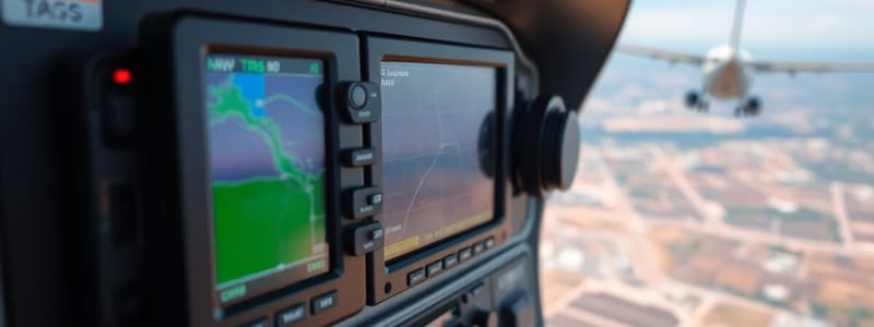
- In modern aircraft, the TCAS display is integrated into the Navigation Display. In older aircraft, it's displayed on the Vertical Speed Indicator (VSI).
- TCAS operation involves communication between all equipped aircraft with appropriate transponders.
- Each TCAS-equipped aircraft interrogates other aircraft within a determined range about their position (via 1030 MHz) and all other aircraft respond to the interrogation (via 1090 MHz).
TCAS operation
- The interrogation-and-response cycle can happen multiple times per second, enabling the system to create a three-dimensional map of all aircraft in the airspace, including their bearing, altitude and range.
- By extrapolating the current range and altitude difference to future values, TCAS determines if a potential collision threat exists.
- Primary Surveillance Radar (PSR) was initially used to support Air Traffic Control (ATC) in the late 1940s.
- PSR displays the plan view position of aircraft but not their identity or altitude.
- Secondary Surveillance Radar (SSR) interacts with transponders on each aircraft to obtain information about identity and altitude (Mode A, Mode C, or Mode S).
- TCAS operates like a miniature SSR, constantly scanning the sky around the aircraft to detect nearby aircraft. This allows sufficient time for avoidance action in high-speed encounters.
TCAS Operation
- TCAS has a 40 nautical mile minimum surveillance range.
- Top and bottom antennas are used to detect aircraft located above and below the own aircraft.
- The static and electronically steered antennas measure aircraft position with an accuracy of 1/125 nautical miles in range and 3 degrees in bearing.
- Antennas operate in temperatures ranging from -60°C to 100°C at airspeeds up to 600 knots.
TCAS Operation
- TCAS constantly interrogates Mode C (Altitude) transponders in nearby aircraft, receiving altitude info.
- Range is calculated from the time it takes for interrogation and reply.
- Bearing is determined using a directional antenna.
- The information from other aircraft's altitude encoder is used to determine the altitude.
- TCAS does not detect aircraft without a functioning Mode A/C or Mode S transponder.
TCAS Symbols
- Non-threat traffic is indicated by an open white diamond on the display. This means the traffic is further than 6 nautical miles away or has more than 1200 ft vertical separation from the given aircraft
- Proximate traffic is shown as a filled diamond with relative altitude annotation. The computer hasn't classified it as a threat.
- Traffic Advisory (TA) is a solid yellow circle indicating potential danger. An aural advisory of "Traffic Traffic" is also given.
- Resolution Advisory (RA) is a red square. The aural advisory is "Descend, Descend". A trapezoid shows restricted aircraft pitch.
- The pilot adjusts the airplane's pitch to be outside the restricted sector.
Human Machine Interface (HMI)
- The HMI has three main elements:
- Plan Position Display of traffic and threat aircraft
- Aural prompts for required actions
- Display of the required avoidance maneuver
Pilot Response to TA & RA
- Pilot response to TA should involve attempting visual acquisition and getting prepared for potential RA.
- Immediate response is needed to RA (within 5 seconds), which requires high reliance on the TCAS system.
- Pilots' general training involves obeying ATC. But if conflicts occur with ATC instruction versus TCAS, the TCAS resolution takes precedence.
Global Positioning system (GPS)
- GPS is a process used to determine the position anywhere on Earth.
- It's developed by the US Department of Defense and used by both civilians and military personnel.
- Civil signal Standard Positioning Service (SPS) is free to use by the public.
- While the military signal Precise Positioning Service (PPS) is only for authorized government agencies.
GPS Working Principle
- GPS allows exact location (longitude, latitude, and altitude), accurate to between 20m and 30 mm.
- Universal Time Coordinated (UTC) accurate to 60 ns to 5 ns.
- Speed and direction of travel can also be derived from coordinates and time.
- The first satellite was launched in 1978 and currently there are 24 operational satellites in space plus spares.
GPS Working Principle
- Satellites are orbiting the Earth at 55 degrees from the equator, ensuring that four satellites are in constant radio contact with any point on Earth.
- Each satellite has 4 atomic clocks and orbits Earth in approximately 12 hours.
- The precise position of each satellite is known at any given time. The receiver determines the distance to the satellites by calculating the time it takes for the GPS signal to arrive.
- Exact satellite position data is transmitted within the satellite's message.
GPS Errors
- Satellite clock error occurs due to slight inaccuracies in synchronization of satellite atomic clocks.
- Ephemeris errors result from minor variations in the satellites' positions as they orbit Earth.
- Atmospheric propagation errors are caused by distortions to the transmitted satellite signal due to the Ionosphere.
- Receiver errors are due to local electrical noise, computational errors, and deviations in matching codes.
GPS System Segments
- GPS consists of three segments:
- Space Segment (SS)
- Control Segment (CS)
- User Segment (US)
Space Segment
- The Space Segment consists of all GPS satellites.
- Each satellite sends position and time data on two frequencies (L1 for civilian, L2 for other purposes).
- L1 operates at 1575.42 MHz. L2 operates at 12287.6 MHz. Signals are digitally modulated with 20 MHz bandwidth.
- Modulation of L1 is through Phase Modulation, where changes in code data correspond to changes in the L1 carrier phase.
Control Segment
- The control segment includes a Master Control Station in Colorado Springs and 4 unmanned stations around the world.
- The stations track satellites and send information to the Master Station.
- Satellites' orbital parameters and clocks are updated.
- Correction data is computed by the Master Station and sent to ground stations for users.
User Segment
- User Segment consists of receivers and GPS users
- Four satellites are needed to calculate the four dimensions (X, Y, Z coordinates) and time required for navigation.
- GPS is mainly used for three-dimensional navigation. GPS receivers are used on aircraft, ships, cars and handheld devices.
- The GPS receiver displays destination information, distance, and speed.
GPS Applications
- The common application of GPS includes navigation in general aviation and commercial air crafts.
- Local Area Augmentation System (LAAS)
- ILS-style display
Studying That Suits You
Use AI to generate personalized quizzes and flashcards to suit your learning preferences.
Related Documents
Description
Test your knowledge on the TCAS system and its advancements over PSR, as well as the application of GPS technology in aviation. This quiz covers the functions of transponders, satellite positioning, and the significance of three-satellite communication. Enhance your understanding of aviation safety and navigation systems.