Podcast
Questions and Answers
What is a primary function of political maps?
What is a primary function of political maps?
- To isolate specific demographic themes.
- To depict natural features like mountains and rivers.
- To represent elevation using contour lines.
- To illustrate governmental boundaries. (correct)
Which type of map would be most beneficial for hikers?
Which type of map would be most beneficial for hikers?
- Choropleth Maps
- Topographic Maps (correct)
- Thematic Maps
- Political Maps
What is a unique characteristic of choropleth maps?
What is a unique characteristic of choropleth maps?
- They use color shading for statistical data. (correct)
- They update in real-time.
- They depict governmental boundaries.
- They represent elevation with lines.
Which of the following best describes a digital map?
Which of the following best describes a digital map?
What does the scale on a map indicate?
What does the scale on a map indicate?
Which type of map focuses on specific themes or data sets?
Which type of map focuses on specific themes or data sets?
In what way do maps assist in emergency response?
In what way do maps assist in emergency response?
Which element of a map helps interpret the symbols and colors used?
Which element of a map helps interpret the symbols and colors used?
What type of data would thematic maps commonly use?
What type of data would thematic maps commonly use?
Which of the following is NOT a typical use of maps?
Which of the following is NOT a typical use of maps?
Flashcards are hidden until you start studying
Study Notes
Maps and Their Uses
Definition of Maps
- A map is a symbolic representation of a geographical area.
- Maps illustrate various features of the Earth, such as landforms, roads, and political boundaries.
Types of Maps
-
Physical Maps
- Depict natural features like mountains, rivers, and lakes.
- Use colors and shading to represent elevation and terrain.
-
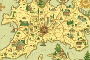
Political Maps
- Show governmental boundaries of countries, states, and cities.
- Indicate major roads and bodies of water.
-
Topographic Maps
- Represent elevation and landforms using contour lines.
- Useful for hikers and land developers.
-
Thematic Maps
- Focus on specific themes or data sets, such as population density or climate.
- Can incorporate statistical information for analysis.
-
Choropleth Maps
- Use color shading to represent statistical data within defined areas.
- Helpful in visualizing data distribution.
-
Digital Maps
- Interactive maps available on platforms like Google Maps.
- Provide real-time navigation and location services.
Uses of Maps
-
Navigation
- Aid in finding routes for travel, whether by foot, vehicle, or air.
-
Planning and Development
- Used in urban planning, resource management, and environmental studies.
-
Education
- Serve as tools for teaching geography, history, and science.
-
Research
- Support data analysis in fields like demographics, climatology, and epidemiology.
-
Cultural Representation
- Illustrate cultural and historical aspects of regions, including languages, religions, and ethnicities.
-
Emergency Response
- Assist in disaster management and response planning by identifying affected areas.
Key Features of Maps
-
Scale
- Indicates the ratio between distances on the map and actual distances on the ground.
-
Legend/Key
- Explains symbols and colors used on the map for better interpretation.
-
Orientation
- Maps usually have a north arrow to indicate direction.
-
Grid System
- Lines of latitude and longitude help in precise location identification.
Limitations of Maps
- May oversimplify complex geographical features.
- Can become outdated; regular updates are necessary for accuracy.
- Subject to interpretation and potential bias based on the creator's perspective.
Definition of Maps
- A map provides a symbolic representation of geographical areas, showcasing features of the Earth like landforms, roads, and political boundaries.
Types of Maps
-
Physical Maps
- Illustrate natural features including mountains, rivers, and lakes with colors indicating elevation and terrain.
-
Political Maps
- Display governmental boundaries such as countries, states, and cities, along with major roads and bodies of water.
-
Topographic Maps
- Use contour lines to represent elevation and landforms, ideal for hikers and land developers.
-
Thematic Maps
- Concentrate on specific themes or datasets (e.g., population density, climate) incorporating statistical information for detailed analysis.
-
Choropleth Maps
- Utilize color shading to visualize statistical data across defined areas, enhancing understanding of data distribution.
-
Digital Maps
- Interactive platforms, like Google Maps, offer real-time navigation and location services, making them widely accessible.
Uses of Maps
-
Navigation
- Essential for determining travel routes whether by foot, vehicle, or air.
-
Planning and Development
- Key tools in urban planning, resource management, and environmental studies.
-
Education
- Function as instructional resources to teach geography, history, and science concepts.
-
Research
- Facilitate data analysis in fields such as demographics, climatology, and epidemiology.
-
Cultural Representation
- Illustrate cultural and historical elements of regions, including languages, religions, and ethnicities.
-
Emergency Response
- Crucial in disaster management, helping to identify affected areas for effective response planning.
Key Features of Maps
-
Scale
- Represents the ratio between distances on the map and real-world distances for accurate navigation.
-
Legend/Key
- Provides explanations for symbols and colors used on the map to aid interpretation.
-
Orientation
- North arrows are typically included to indicate direction and improve navigational accuracy.
-
Grid System
- Lines of latitude and longitude enable precise location identification on the Earth's surface.
Limitations of Maps
- Potential to oversimplify complex geographical features, leading to loss of detail.
- May become outdated, necessitating regular updates to maintain accuracy.
- Interpretation can be influenced by the creator’s perspective, introducing potential bias.
Studying That Suits You
Use AI to generate personalized quizzes and flashcards to suit your learning preferences.