Podcast
Questions and Answers
Which of the following best describes the relationship between the Earth's compositional and mechanical layers?
Which of the following best describes the relationship between the Earth's compositional and mechanical layers?
- Compositional layers define the physical state of matter, while mechanical layers describe the Earth's material makeup.
- Compositional layers are synonymous with mechanical layers and describe both the material makeup and internal activities.
- Compositional layers are defined by the material makeup, whereas mechanical layers are defined by the processes and activities within those materials. (correct)
- Mechanical layers are based on rock type, whereas compositional layers are based on heat flow and convection.
Which of these is the best example of a divergent plate boundary?
Which of these is the best example of a divergent plate boundary?
- The San Andreas Fault
- The Himalayan mountain range
- The Mariana Trench
- The Mid-Atlantic Ridge (correct)
In the context of plate tectonics, what is the primary result of subduction?
In the context of plate tectonics, what is the primary result of subduction?
- Recycling of crustal material into the mantle (correct)
- Formation of rift valleys and new crust
- Creation of transform faults at plate edges
- Lateral sliding of tectonic plates
Which of the following statements accurately describes the difference between a hypothesis and a theory in science?
Which of the following statements accurately describes the difference between a hypothesis and a theory in science?
How do convection currents in the Earth's mantle contribute to the movement of tectonic plates?
How do convection currents in the Earth's mantle contribute to the movement of tectonic plates?
Which geological process is primarily responsible for the formation of oceanic trenches?
Which geological process is primarily responsible for the formation of oceanic trenches?
Which list places the geologic eras in the correct order from oldest to most recent?
Which list places the geologic eras in the correct order from oldest to most recent?
Which of the following best describes the process of lithification?
Which of the following best describes the process of lithification?
Which of these is an example of an extrusive igneous rock?
Which of these is an example of an extrusive igneous rock?
Which process is NOT a part of the rock cycle?
Which process is NOT a part of the rock cycle?
Which of the following is a key difference between weather and climate?
Which of the following is a key difference between weather and climate?
Which of the following statements best describes the 'rain-shadow' effect?
Which of the following statements best describes the 'rain-shadow' effect?
What is the key difference between maritime and continental climates?
What is the key difference between maritime and continental climates?
Which of the following best describes the relationship between the Earth's four spheres?
Which of the following best describes the relationship between the Earth's four spheres?
Alfred Wegener's theory of continental drift was initially rejected despite supporting evidence. Which statement best explains this?
Alfred Wegener's theory of continental drift was initially rejected despite supporting evidence. Which statement best explains this?
How does plate tectonics explain volcanic eruptions?
How does plate tectonics explain volcanic eruptions?
Why do we use 'geologic eras' to measure Earth's history?
Why do we use 'geologic eras' to measure Earth's history?
What makes the rock cycle a 'cycle'?
What makes the rock cycle a 'cycle'?
How does the water cycle interact with the rock cycle?
How does the water cycle interact with the rock cycle?
Which climate factor most directly influences the total annual precipitation of a region?
Which climate factor most directly influences the total annual precipitation of a region?
What is the main reason that Plate Tectonics theory was considered better than Continental Drift theory?
What is the main reason that Plate Tectonics theory was considered better than Continental Drift theory?
Which of the following best exemplifies a biotic component within a geographical system?
Which of the following best exemplifies a biotic component within a geographical system?
According to the information provided, what is the primary energy source driving the movement of tectonic plates?
According to the information provided, what is the primary energy source driving the movement of tectonic plates?
Which of the following is a direct observation supporting Wegener’s theory of continental drift?
Which of the following is a direct observation supporting Wegener’s theory of continental drift?
Which of these best describes the interaction between the lithosphere and asthenosphere?
Which of these best describes the interaction between the lithosphere and asthenosphere?
A transform plate boundary is most accurately described by which of the following?
A transform plate boundary is most accurately described by which of the following?
Which of the following geological events is LEAST likely to result in the formation of mountains or plateaus?
Which of the following geological events is LEAST likely to result in the formation of mountains or plateaus?
During which geologic era did the most significant changes occur in Canada's geological landscape?
During which geologic era did the most significant changes occur in Canada's geological landscape?
The transformation of a sedimentary rock into a metamorphic rock involves which of the following processes?
The transformation of a sedimentary rock into a metamorphic rock involves which of the following processes?
Which of the following rock types is NOT formed from igneous processes?
Which of the following rock types is NOT formed from igneous processes?
Which term best describes the process by which sediments are turned into sedimentary rock?
Which term best describes the process by which sediments are turned into sedimentary rock?
Which of these processes involves a change of state from solid directly to gas?
Which of these processes involves a change of state from solid directly to gas?
What is the primary cause of relief rainfall?
What is the primary cause of relief rainfall?
If a location has a climate with a high annual temperature range and relatively low precipitation, it is MOST likely to be described as:
If a location has a climate with a high annual temperature range and relatively low precipitation, it is MOST likely to be described as:
How do mantle plumes contribute to the processes observed at the lithosphere?
How do mantle plumes contribute to the processes observed at the lithosphere?
Which climatic factor primarily determines the length of a region's growing season?
Which climatic factor primarily determines the length of a region's growing season?
Which process is essential for converting sediments into sedimentary rock?
Which process is essential for converting sediments into sedimentary rock?
How does the concept of the '4 spheres' relate to the water cycle?
How does the concept of the '4 spheres' relate to the water cycle?
What is the significance of identifying specific locations or examples when visualizing the rock cycle?
What is the significance of identifying specific locations or examples when visualizing the rock cycle?
Why were the interpretations of Wegener's observations initially deemed insufficient to establish continental drift as established scientific theory?
Why were the interpretations of Wegener's observations initially deemed insufficient to establish continental drift as established scientific theory?
How does plate tectonics theory explain the occurrence of tsunamis?
How does plate tectonics theory explain the occurrence of tsunamis?
What is the relationship between 'maximum seasonal precipitation' and regional climate graphs?
What is the relationship between 'maximum seasonal precipitation' and regional climate graphs?
Which of the following is NOT a primary type of geological change associated with the formation of mountains or plateaus?
Which of the following is NOT a primary type of geological change associated with the formation of mountains or plateaus?
Which of the following geological eras is characterized by the emergence of complex life forms, including the first vertebrates?
Which of the following geological eras is characterized by the emergence of complex life forms, including the first vertebrates?
Which of the following rock types is formed through the process of metamorphism?
Which of the following rock types is formed through the process of metamorphism?
Which of the following processes is NOT directly involved in the formation of sedimentary rocks?
Which of the following processes is NOT directly involved in the formation of sedimentary rocks?
Which of the following geographical features is most closely associated with divergent plate boundaries?
Which of the following geographical features is most closely associated with divergent plate boundaries?
Which of the following factors primarily influences the temperature and precipitation patterns of a region's climate?
Which of the following factors primarily influences the temperature and precipitation patterns of a region's climate?
Which of the following best describes the process of condensation in the water cycle?
Which of the following best describes the process of condensation in the water cycle?
Which of the following is the most accurate definition of 'relief rainfall'?
Which of the following is the most accurate definition of 'relief rainfall'?
Which layer of the Earth is composed of solid rock and forms the outermost shell?
Which layer of the Earth is composed of solid rock and forms the outermost shell?
Which of the following accurately describes the process of subduction?
Which of the following accurately describes the process of subduction?
Which of the following best defines synergy in an ecological system?
Which of the following best defines synergy in an ecological system?
What observation did Alfred Wegener NOT use to support his theory of continental drift?
What observation did Alfred Wegener NOT use to support his theory of continental drift?
Which force is NOT considered a driving factor in plate tectonics?
Which force is NOT considered a driving factor in plate tectonics?
What primarily contributes to the length of a region's growing season?
What primarily contributes to the length of a region's growing season?
Which key observation by Alfred Wegener was NOT part of his evidence for continental drift?
Which key observation by Alfred Wegener was NOT part of his evidence for continental drift?
How do plate tectonics help explain the occurrence of earthquakes?
How do plate tectonics help explain the occurrence of earthquakes?
Why is the rock cycle considered a cycle?
Why is the rock cycle considered a cycle?
Which factor is essential in the interaction between the water cycle and the rock cycle?
Which factor is essential in the interaction between the water cycle and the rock cycle?
What is a primary reason Wegener's hypothesis failed to gain acceptance initially?
What is a primary reason Wegener's hypothesis failed to gain acceptance initially?
Which statement best explains the significance of measuring Earth's history in geologic eras?
Which statement best explains the significance of measuring Earth's history in geologic eras?
Which of the following best describes a function of the lithosphere in relation to plate tectonics?
Which of the following best describes a function of the lithosphere in relation to plate tectonics?
Flashcards
What are biotic parts in a system?
What are biotic parts in a system?
Parts of a system that are living, such as plants and animals.
Distinguish between a natural and a human system.
Distinguish between a natural and a human system.
A natural system includes only non-human components, while a human system involves humans interacting with those components.
What is Plate Tectonics Theory?
What is Plate Tectonics Theory?
The theory explaining the movement of Earth's tectonic plates due to convection currents in the mantle. This movement causes earthquakes, volcanoes, and mountain formation.
What is subduction?
What is subduction?
Signup and view all the flashcards
What is a divergent plate boundary?
What is a divergent plate boundary?
Signup and view all the flashcards
How are volcanic mountains formed?
How are volcanic mountains formed?
Signup and view all the flashcards
How are folded mountains formed?
How are folded mountains formed?
Signup and view all the flashcards
How are fault-block mountains formed?
How are fault-block mountains formed?
Signup and view all the flashcards
What is a plateau?
What is a plateau?
Signup and view all the flashcards
What is a rift valley?
What is a rift valley?
Signup and view all the flashcards
Range of Temperatures
Range of Temperatures
Signup and view all the flashcards
Total Annual Precipitation
Total Annual Precipitation
Signup and view all the flashcards
Growing Season
Growing Season
Signup and view all the flashcards
Continental Drift Theory
Continental Drift Theory
Signup and view all the flashcards
Plate Tectonics Theory
Plate Tectonics Theory
Signup and view all the flashcards
Geological Eras
Geological Eras
Signup and view all the flashcards
Rock Cycle
Rock Cycle
Signup and view all the flashcards
Water Cycle
Water Cycle
Signup and view all the flashcards
Study Notes
EXAM STUDY GUIDE – CGC1D1 – GEOGRAPHY GRADE 9
Exam duration: 90 minutes
Unit 3: Physical Geography – the Geography of the Natural World
-
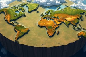
Geo-Physical Systems: Recognizing the fundamental distinctions within geo-physical systems is crucial for explaining how different processes interact in our world. Natural systems, which encompass processes occurring in nature independently of human influence, maintain a delicate balance essential for sustaining life on the planet. These processes include various ecological dynamics, climatic patterns, and geological transformations. In contrast, human systems are shaped by activities such as urban development, agriculture, and industry, which can alter these natural processes significantly. For a comprehensive study of the environment, it is imperative to examine both biotic components, which consist of all living entities such as animals, plants, fungi, and bacteria, and the interactions among them, and abiotic components, which consist of non-living factors like minerals, water, sunlight, and air that are essential for life. A deep understanding of the intricate cycles of the atmosphere—the layer of gases that envelop the Earth, critical for weather and climate regulation—hydrosphere—all forms of water including oceans, rivers, lakes, glaciers, and groundwater—and lithosphere—the solid outer layer of the Earth composed of landforms, soil, and minerals, along with the biosphere—the collective zones of life on Earth, including ecosystems and habitats, offers important insights into their interconnectedness and the impact on the environment. Each system plays a unique role in influencing the Earth's environment and supporting life; for example, nutrient cycling between biotic and abiotic elements is pivotal for ecosystem health, while the atmosphere is responsible for regulating temperature and influencing weather patterns, which have far-reaching effects on both natural habitats and human livelihoods.
-
Continental Drift Theory: The Continental Drift Theory suggests that the continents, as we recognize them today, were once part of a large, single landmass referred to as Pangaea—a supercontinent that existed during the late Paleozoic and early Mesozoic eras. Over millions of years, this landmass gradually split and drifted apart due to the movement of tectonic plates, leading to the current configuration of continents. This theory not only elucidates the movement of tectonic plates but also provides explanations for many geological features we observe today, such as mountain ranges, valley formations, and ocean trenches. Its implications are immense, contributing to the foundational understanding of plate tectonics—a scientific theory that encompasses the movement and interaction of Earth's plates and underpins much of our understanding of geological processes. The theory enhances our comprehension of natural disasters like earthquakes and volcanic eruptions, which frequently result from the interactions and movements of these tectonic plates. Furthermore, by examining the fossilized remains of extinct species discovered across different continents, scientists find compelling evidence supporting the notion that these landmasses were once interconnected, establishing the historical continuity of ecosystems before their separation due to continental drift. Alfred Wegener, who pioneered this theory, based his work on four main observations: the jig-saw-like fit of the continents, the similarities in fossils found on widely separated landmasses, geological correspondences suggesting identical erosion processes, and climatic evidence indicating similar patterns in different geographic locations, thus reinforcing the validity of this transformative theory.
-
Wegener underscored specific pieces of evidence crucial to the formulation of the Continental Drift Theory, such as the striking resemblance of geological formations located on the coastlines of South America and Africa. For example, the Appalachian Mountains in North America share geological characteristics and age with the Caledonian Mountains in Scotland, suggesting these formations were once part of the same mountain chain before continental separation. Such observations helped to develop a clearer understanding of how these landmasses were once interconnected, significantly leading to the conceptualization of Pangaea and providing a coherent framework to understand the geological and climatic history of our planet.
-
Plate Tectonics Theory: The Plate Tectonics Theory elaborates on the complex structure of the Earth, segmenting it into three primary layers: the core, mantle, and crust. The core consists of a solid inner layer and a liquid outer layer comprised mainly of iron and nickel. Surrounding the core is the mantle, a thick layer made up of semi-fluid rock that behaves like a viscous fluid over geological time. The outermost layer is the crust, where we experience the Earth's surface. The dynamics of tectonic plates floating on the semi-fluid mantle layer significantly influence the formation and alteration of the Earth's landscapes. The interactions at the boundaries of these tectonic plates, which can be classified as convergent, divergent, or transform, are crucial to understanding geological activities. Convergent boundaries, where two plates meet, often give rise to subduction zones—areas where one plate descends beneath another, leading to volcanic activity and the formation of mountain ranges. Divergent boundaries, conversely, occur where tectonic plates separate and create new oceanic crust as magma rises from below the mantle; this process generates rift valleys and mid-ocean ridges. Transform boundaries, where plates slide past each other, result in friction and sometimes produce significant seismic activity, such as earthquakes, which demonstrates the dynamic and ever-changing nature of our planet.
-
Geologic Time: The concept of geologic time encompasses the immense temporal scales over which geological processes shape the Earth, categorizing these timescales into eras and periods that reflect significant transformations in the planet's history, including the formation and breakup of supercontinents, shifts in climate, and periods of mass extinction. The geologic time scale is a chronological framework that helps scientists interpret the history of the Earth, using stratigraphy and fossil records to establish the relative ages of rock layers. Such examinations reveal essential insights into the geological history of both Canada and global landscapes over millions of years. For example, the study of sedimentary layers can illuminate the environments present at different time frames, whether they indicate ancient river systems, oceanic deposits, or glacial activity. Understanding the concept of geologic time is critical not only for contextualizing current environmental challenges but also for highlighting the natural rhythms and cycles of change that have continually reshaped the planet in response to various geological forces and climatic shifts.
-
Rocks and the Rock Cycle: The rock cycle is a comprehensive and continuous process through which rocks are formed, degraded, and recycled in an ever-changing system. This cycle consists of three primary types of rocks: igneous rocks, which originate from the cooling and solidification of magma or lava; sedimentary rocks, which are formed from the accumulation and compaction of sediments, mainly composed of fragments of existing rocks, minerals, and organic materials, often resulting in layered structures; and metamorphic rocks, which represent altered forms of either igneous or sedimentary rocks that have undergone significant changes due to heat, pressure, or chemically active fluids. The rock cycle illustrates the intricate relationships between different rock types and the dynamic processes that contribute to shaping the landscape, forming soil, and providing essential materials for various natural and human activities. Each stage of the rock cycle shows how rocks can transition between different forms over time, highlighting the interconnectedness of geological processes and reinforcing the importance of understanding the cycling of materials in maintaining Earth's ecosystems.
-
Climate: Climate refers to the long-term patterns and averages of temperature, humidity, and precipitation in a given region, influenced by a multitude of factors such as latitude, ocean currents, elevation, topography, vegetation, and geographic position relative to large water bodies. Understanding climate is crucial for a range of applications, from agriculture to disaster preparedness. It is essential to distinguish climate from weather, which pertains to short-term atmospheric conditions that can fluctuate dramatically over brief periods. The study of climate typically involves analyzing six critical factors, often encapsulated in the acronym L.O.W.E.R.N: Latitude (which affects solar radiation), Ocean currents (which influence temperature and precipitation patterns), Wind patterns (which redistribute heat and moisture), Elevation (which affects temperature and precipitation due to altitude), Relief (topographical features that impact weather patterns), and Nearness to water (which moderates temperatures and increases humidity). Together, these elements shape regional climate characteristics and have profound implications for local biodiversity, agricultural practices, and overall human habitation.
-
Recognizing these six factors helps in explaining the variations in climate experienced across different regions, which can provide insights into the corresponding ecosystems that thrive in those areas. The roles of temperature and precipitation patterns are paramount, as they regulate the availability of water resources and determine the types of flora and fauna that can prosper. Air masses, defined as large regions of uniform temperature and humidity, play a pivotal role in weather patterns and are influenced by prevailing winds such as the westerlies, affecting local climatic conditions. The intricate processes of condensation, sublimation, precipitation, and evaporation drive the water cycle, a critical component of the climate system, while other mechanisms such as relief rainfall, rain-shadow effects, and the interaction between windward and leeward slopes amplify the complexity of climate interactions.
-
In Canada, it is crucial to differentiate between maritime and continental climates. Maritime climates, typically found along the coastal regions, are defined by milder temperatures and elevated humidity levels due to the moderating influence of nearby oceans and large water bodies. Conversely, continental climates, predominantly located in the interior regions, display more extreme temperature fluctuations throughout the year, with greater differences observed between summer and winter conditions, and generally lower humidity. These distinctions significantly influence the ecosystems and weather patterns throughout the country, creating diverse habitats ranging from temperate rainforests in coastal British Columbia to the arid conditions of the Prairies. To effectively analyze climate data, climate graphs serve as invaluable tools that visualize and compare various climate metrics, showcasing aspects such as average annual temperature, temperature range across seasons, total annual precipitation, peak seasonal precipitation levels, and the length of the growing season. Such visual representations facilitate a better understanding of the suitability of different regions for various types of agriculture and forestry, along with predicting how ongoing climate change may further modify these established patterns.
Studying That Suits You
Use AI to generate personalized quizzes and flashcards to suit your learning preferences.