Podcast
Questions and Answers
Which of the following is NOT a part of a good map?
Which of the following is NOT a part of a good map?
- Compass rose
- Population density (correct)
- Title
- Legend
Maritime climates are characterized by more extreme temperature variations compared to continental climates.
Maritime climates are characterized by more extreme temperature variations compared to continental climates.
False (B)
What are the three main types of job sectors in urban geography?
What are the three main types of job sectors in urban geography?
Primary, Secondary, Tertiary
Canada's capital city is __________.
Canada's capital city is __________.
Match the following provinces/territories to their capitals:
Match the following provinces/territories to their capitals:
What is the primary factor contributing to population distribution in Canada?
What is the primary factor contributing to population distribution in Canada?
A population pyramid provides a visual representation of age and sex distribution within a population.
A population pyramid provides a visual representation of age and sex distribution within a population.
What is the Rule of 70 used for in population studies?
What is the Rule of 70 used for in population studies?
Which of the following components is NOT part of a good map?
Which of the following components is NOT part of a good map?
Canada has the smallest population of any country in North America.
Canada has the smallest population of any country in North America.
What is the capital of Canada?
What is the capital of Canada?
The __________ shows the relationship between map distances and real-world distances.
The __________ shows the relationship between map distances and real-world distances.
Which region is NOT a physical landform region of Canada?
Which region is NOT a physical landform region of Canada?
Most Canadians live in the northern regions of the country.
Most Canadians live in the northern regions of the country.
Name one factor that affects climate in Canada.
Name one factor that affects climate in Canada.
Match the following Canadian provinces/territories with their capitals:
Match the following Canadian provinces/territories with their capitals:
What defines the climate of an area?
What defines the climate of an area?
Maritime climates are characterized by extreme temperature ranges.
Maritime climates are characterized by extreme temperature ranges.
Name one type of precipitation caused by warm and cold air masses colliding.
Name one type of precipitation caused by warm and cold air masses colliding.
The primary layers of soil include topsoil, subsoil, parent material, and ______.
The primary layers of soil include topsoil, subsoil, parent material, and ______.
Match the following job sectors with their definitions:
Match the following job sectors with their definitions:
Which of the following is NOT a push factor influencing migration?
Which of the following is NOT a push factor influencing migration?
The Rule of 70 helps to estimate the doubling time of a population.
The Rule of 70 helps to estimate the doubling time of a population.
List one renewable resource.
List one renewable resource.
Flashcards
Map Scale
Map Scale
The ratio of a distance on a map to the corresponding distance on the ground.
Map
Map
A visual representation of Earth's surface, showing features and locations.
Weather vs. Climate
Weather vs. Climate
The difference between weather and climate. Weather is short-term atmospheric conditions, while climate is the long-term average weather pattern over a region.
Climate Factor
Climate Factor
Signup and view all the flashcards
Topsoil
Topsoil
Signup and view all the flashcards
Birth Rate
Birth Rate
Signup and view all the flashcards
Immigration
Immigration
Signup and view all the flashcards
Sustainable Development
Sustainable Development
Signup and view all the flashcards
Map Legend
Map Legend
Signup and view all the flashcards
Representative Fraction (RF)
Representative Fraction (RF)
Signup and view all the flashcards
Compass Rose
Compass Rose
Signup and view all the flashcards
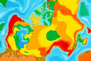
Canada's Population Distribution
Canada's Population Distribution
Signup and view all the flashcards
Population Density
Population Density
Signup and view all the flashcards
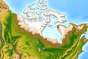
Physical Landform Regions of Canada
Physical Landform Regions of Canada
Signup and view all the flashcards
Factors Affecting Canada's Climate
Factors Affecting Canada's Climate
Signup and view all the flashcards
Canada's Aging Population
Canada's Aging Population
Signup and view all the flashcards
Weather
Weather
Signup and view all the flashcards
Climate
Climate
Signup and view all the flashcards
Orographic Precipitation
Orographic Precipitation
Signup and view all the flashcards
Convectional Precipitation
Convectional Precipitation
Signup and view all the flashcards
Population Pyramid
Population Pyramid
Signup and view all the flashcards
Push Factors
Push Factors
Signup and view all the flashcards
Pull Factors
Pull Factors
Signup and view all the flashcards
Study Notes
Map Skills
- Parts of a good map include title, legend, scale, compass rose, and grid system.
- Mapping scales include representative fraction, linear scale, and verbal scale.
- Direction and distances can be determined using scales and tools.
Canada Geography
- Provinces, territories, neighbors, and capital cities should be identifiable on a map.
- Knowledge of Canada's area and population demographics.
- Patterns and reasons for population spread and distribution.
- Effects of an aging population on society and resources.
Physical Geography
- Characteristics of Canada's landform regions.
- Climate factors include latitude, ocean currents, wind/pressure systems, and elevation.
- Types of precipitation include relief (orographic), convectional, and frontal/cyclonic.
- Differences between weather and climate.
- Maritime vs. continental climate characteristics.
- Interpreting climate graphs.
- Soil layers like topsoil and subsoil.
- Soil classification and vegetation regions are linked to climate.
Population Studies
- Key definitions including birth rate, death rate, immigration rate, etc.
- Push and pull factors and the rule of 70 for doubling time.
- Understanding population pyramids for age/sex distribution.
- Immigration patterns over time.
Urban and Economic Geography
- Types of urban land use and distribution.
- Job sectors: primary, secondary, tertiary, and quaternary.
- Renewable (forests, fish) and non-renewable (fossil fuels, minerals) resources.
- Sustainable development practices.
Energy and Environmental Studies
- Methods of resource extraction (open-pit mining, forestry, oil sands).
- Energy use, alternative energy sources (solar, wind, geothermal), and conventional energy.
- High energy use due to transportation, industry, and heating needs.
- Ecological footprints and the 5 R's.
Global Connections
- Eating locally vs. globally and associated impacts (carbon footprint, food diversity).
- Trade agreements like USMCA, TPP, and CETA.
- The multiplier effect on economic growth from investments.
Studying That Suits You
Use AI to generate personalized quizzes and flashcards to suit your learning preferences.