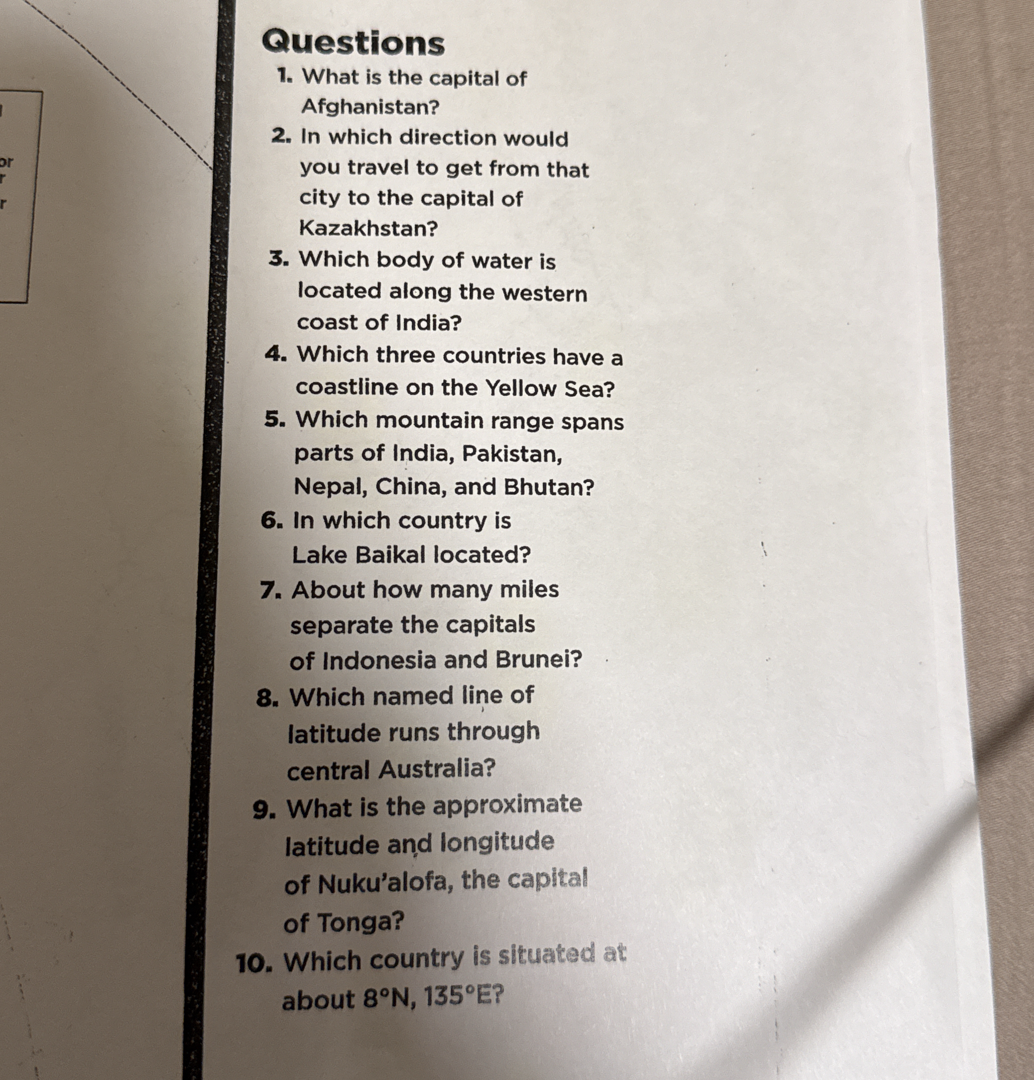
What is the capital of Afghanistan? In which direction would you travel to get from that city to the capital of Kazakhstan? Which body of water is located along the western coast o... What is the capital of Afghanistan? In which direction would you travel to get from that city to the capital of Kazakhstan? Which body of water is located along the western coast of India? Which three countries have a coastline on the Yellow Sea? Which mountain range spans parts of India, Pakistan, Nepal, China, and Bhutan? In which country is Lake Baikal located? About how many miles separate the capitals of Indonesia and Brunei? Which named line of latitude runs through central Australia? What is the approximate latitude and longitude of Nuku’alofa, the capital of Tonga? Which country is situated at about 8°N, 135°E?
Understand the Problem
The question is a series of geography-related inquiries, asking for capitals, geographical locations, and distances between countries. The goal is to provide accurate information about various geographic topics.
Answer
1. Kabul, 2. North, 3. Arabian Sea, 4. China, North Korea, South Korea, 5. Himalayas, 6. Russia, 7. 730 miles, 8. Tropic of Capricorn, 9. 21.13°S 175.2°W, 10. Palau.
- The capital of Afghanistan is Kabul. 2. You would travel north to get from Kabul to Nur-Sultan, the capital of Kazakhstan. 3. The Arabian Sea is located along the western coast of India. 4. China, North Korea, and South Korea have coastlines on the Yellow Sea. 5. The Himalayas span parts of India, Pakistan, Nepal, China, and Bhutan. 6. Lake Baikal is located in Russia. 7. The capitals of Indonesia (Jakarta) and Brunei (Bandar Seri Begawan) are about 730 miles apart. 8. The Tropic of Capricorn is the named line of latitude running through central Australia. 9. The approximate latitude and longitude of Nuku’alofa, Tonga, is 21.13°S and 175.2°W. 10. The country situated at about 8°N, 135°E is Palau.
Answer for screen readers
- The capital of Afghanistan is Kabul. 2. You would travel north to get from Kabul to Nur-Sultan, the capital of Kazakhstan. 3. The Arabian Sea is located along the western coast of India. 4. China, North Korea, and South Korea have coastlines on the Yellow Sea. 5. The Himalayas span parts of India, Pakistan, Nepal, China, and Bhutan. 6. Lake Baikal is located in Russia. 7. The capitals of Indonesia (Jakarta) and Brunei (Bandar Seri Begawan) are about 730 miles apart. 8. The Tropic of Capricorn is the named line of latitude running through central Australia. 9. The approximate latitude and longitude of Nuku’alofa, Tonga, is 21.13°S and 175.2°W. 10. The country situated at about 8°N, 135°E is Palau.
More Information
These questions cover a broad range of geographical facts including capitals, bodies of water, and major geographical features.
Tips
A common mistake is confusing directionality due to map orientation or distances between cities—double-check with a map.
Sources
- World Geography - Encyclopedia - britannica.com
- Coordinates of Global Cities - GeoNames - geonames.org
- Mountain Ranges - World Atlas - worldatlas.com
AI-generated content may contain errors. Please verify critical information
Thank you for voting!