Podcast
Questions and Answers
How does the perennial nature of Himalayan rivers contribute to their significance in the region?
How does the perennial nature of Himalayan rivers contribute to their significance in the region?
- It limits the formation of meanders and oxbow lakes in the middle and lower courses.
- It decreases the rivers' capacity to erode soil in the upper course.
- It reduces the risk of flooding during the monsoon season.
- It ensures a consistent water supply for irrigation and domestic use throughout the year. (correct)
What is the primary factor that determines whether a river is classified as a Himalayan river or a Peninsular river?
What is the primary factor that determines whether a river is classified as a Himalayan river or a Peninsular river?
- The type of drainage pattern it exhibits (e.g., dendritic, radial).
- Its length and width compared to other rivers in India.
- The direction in which it flows (east or west).
- Its origin and whether it is fed by snowmelt and rainfall or primarily by rainfall. (correct)
What is the geographical significance of the Western Ghats in the context of Peninsular rivers?
What is the geographical significance of the Western Ghats in the context of Peninsular rivers?
- They serve as the primary source of water for all major rivers in India.
- They prevent the formation of deltas by accelerating the flow of rivers into the Bay of Bengal.
- They act as a water divider, influencing the direction of flow for many Peninsular rivers. (correct)
- They are the location where the majority of Peninsular rivers drain into the Arabian Sea.
Which of the following best describes the relationship between the Bhagirathi and Alaknanda rivers and the Ganga River?
Which of the following best describes the relationship between the Bhagirathi and Alaknanda rivers and the Ganga River?
How do the characteristics of the Brahmaputra River in Tibet differ from its characteristics as it flows through Assam and Arunachal Pradesh in India?
How do the characteristics of the Brahmaputra River in Tibet differ from its characteristics as it flows through Assam and Arunachal Pradesh in India?
What impact do rivers originating in the Nepal Himalayas, such as the Gandak and Kosi, have on the northern plains of India?
What impact do rivers originating in the Nepal Himalayas, such as the Gandak and Kosi, have on the northern plains of India?
How does the Indus River system contribute to the agricultural and economic activities in the regions it traverses?
How does the Indus River system contribute to the agricultural and economic activities in the regions it traverses?
Which of the following statements accurately describes the formation and characteristics of an oxbow lake?
Which of the following statements accurately describes the formation and characteristics of an oxbow lake?
What is the significance of the Sundarbans Delta, formed by the Ganga and Brahmaputra rivers, in terms of environmental and ecological importance?
What is the significance of the Sundarbans Delta, formed by the Ganga and Brahmaputra rivers, in terms of environmental and ecological importance?
How does the concept of a 'water divider' apply to the major drainage systems in India, and what is its effect on river flow?
How does the concept of a 'water divider' apply to the major drainage systems in India, and what is its effect on river flow?
Flashcards
Drainage System
Drainage System
The systematic pattern of rivers in a region.
River Basin
River Basin
An area drained by a river and its tributaries.
Water Divider
Water Divider
A highland or ridge that separates one drainage basin from another.
Perennial Rivers
Perennial Rivers
Signup and view all the flashcards
Meanders
Meanders
Signup and view all the flashcards
Oxbow Lake
Oxbow Lake
Signup and view all the flashcards
Delta
Delta
Signup and view all the flashcards
Tributary
Tributary
Signup and view all the flashcards
River System
River System
Signup and view all the flashcards
Devprayag
Devprayag
Signup and view all the flashcards
Study Notes
- World's Drainage System: The systematic pattern of rivers.
India's Physiography
- Contains mountains, valleys, plateaus, and plains.
- Rivers and tributaries flow through various terrains.
- Water empties into seas or deserts.
- River Basin: The system through which a river flows into an area.
Water Divider
- When a mountain divides water flow into two, it's a water divider.
Indian Drainage Systems
- Divided based on mountain ranges.
- Can be divided into two zones according to physical features.
- Two categories: Himalayan Rivers and Peninsular Rivers.
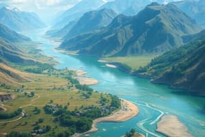
Himalayan Rivers
- Perennial, flowing throughout the year.
- Fed by snowmelt and rainfall hence, water volume is constant.
Major Himalayan Rivers
- Indus, Ganga, and Brahmaputra.
- Originate in the northern mountains.
- Rivers cut through mountains, creating large gorges.
River Systems Patterns
- Dendritic, rectangular, radial, and trellis patterns.
Stages of a River
- Upper Course: River starts.
- Middle Course: River flows.
- Lower Course: River nears the sea.
- Meanders: Turns in the river's path.
- Oxbow Lake: Cut-off meanders forming lakes.
- Delta: Area where the river meets the sea, dividing into distributaries.
- Rivers erode soil in their upper course, carrying sediment.
- Flow decreases in middle and lower courses, leading to meanders.
Peninsular Rivers
- Seasonal, dependent on rainfall.
- Flow fluctuates or ceases during the dry season.
- Shorter and shallower than Himalayan rivers.
- Originate from the Western Ghats.
- Most flow towards the Bay of Bengal.
- Western Ghats as water dividers directing flows to the waters
Major Himalayan River Systems
- Indus, Ganga, and Brahmaputra.
- Long rivers joined by tributaries.
- Tributary: A river that flows into a larger river.
- River System: Patterned network of river flows.
Indus River System
- Originates from Mansarovar in Tibet.
- Flows west then northwest, enters India through Ladakh.
- Rivers such as Zaskar, Nubra, and Shyok join it.
Tributaries of the Indus River
- Satluj, Beas, Ravi, Chenab, and Jhelum.
- These all merge into Indus River at Mithankot in Pakistan.
- Merged rivers flow south, drain into the Arabian Sea.
- About one-third of the Indus River basin is in in Jammu and Kashmir, Himachal, and Punjab and the rest is in Pakistan.
Ganga River System
- The Bhagirathi and Alaknanda rivers merge at Devprayag, Uttarakhand.
- Ganga exits the mountains begins in the plains at Haridwar.
- Himalayan rivers such as the Yamuna flow into Ganga.
- The Yamuna originates from the Yamunotri Glacier, merges at Allahabad to form what is called 'Sangam'
- Rivers such as Gandak and Kosi originate in Nepal Himalayas.
- Cause annual floods and property loss in the northern plains.
- Rivers Chamba and Betwa rise from peninsular plateaus and empty into the Yamuna.
- Son is a river that empties into the Ganga.
- Some rivers originate in semi-arid regions, have short courses, and limited water volume.
- Ganga's flow divides into two branches downstream which leads to Bangladesh.
- 1 branch enters Bangladesh as Padma, the other flows through West Bengal as Bhagirathi-Hooghly.
- Ganga merges with Brahmaputra - combined flow is named Meghna and that flows into the Bay of Bengal at the Sundarbans Delta.
Brahmaputra River System
- The rivers source is near to the Indus and Satluj in Tibet.
- Flows east, parallel to the Himalayas.
- Enters India in Arunachal Pradesh, known as Dihang.
- The Dibang, Lohit, and other tributaries join at Assam, turning this river into Brahmaputra.
- Brahmaputra carries less silt than the Indus River and contains rich sediments.
- Brahmaputra is known for channel islands.
- Heavy rainfall causes annual flooding in Assam and Arunachal Pradesh.
- High silt deposits raise river beds, causing frequent course changes.
Studying That Suits You
Use AI to generate personalized quizzes and flashcards to suit your learning preferences.