Podcast
Questions and Answers
What is the primary characteristic of the water cycle that classifies it as a closed system?
What is the primary characteristic of the water cycle that classifies it as a closed system?
- The continuous addition of new water sources from space.
- A fixed amount of water that is neither increased nor decreased. (correct)
- A fluctuating volume of water due to climate change.
- The ability of the system to purify polluted water.
Interception refers to the process where water is absorbed directly from the atmosphere into the groundwater stores.
Interception refers to the process where water is absorbed directly from the atmosphere into the groundwater stores.
False (B)
Name two major stores of water within the water cycle.
Name two major stores of water within the water cycle.
waterbodies and the atmosphere
The combined process of evaporation from waterbodies and transpiration from plants is known as ______.
The combined process of evaporation from waterbodies and transpiration from plants is known as ______.
Which of the following processes involves the change of water from a gaseous state to a liquid state?
Which of the following processes involves the change of water from a gaseous state to a liquid state?
Match the following processes with their descriptions:
Match the following processes with their descriptions:
How does solar energy primarily influence the water cycle?
How does solar energy primarily influence the water cycle?
Describe what is meant by 'groundwater store'.
Describe what is meant by 'groundwater store'.
What is the key distinction between 'infiltration' and 'percolation' in the context of water transfer?
What is the key distinction between 'infiltration' and 'percolation' in the context of water transfer?
A watershed is best described as an area of land drained by a main river and its tributaries.
A watershed is best described as an area of land drained by a main river and its tributaries.
Define 'drainage density' and explain how it is calculated.
Define 'drainage density' and explain how it is calculated.
The point where a river enters an ocean or sea is known as its ______.
The point where a river enters an ocean or sea is known as its ______.
Match the following drainage basin features with their descriptions:
Match the following drainage basin features with their descriptions:
Which of the following is NOT considered a typical output of a drainage basin?
Which of the following is NOT considered a typical output of a drainage basin?
Which of the following describes 'throughflow'?
Which of the following describes 'throughflow'?
A drainage basin is considered a closed system because water is neither added nor lost from it.
A drainage basin is considered a closed system because water is neither added nor lost from it.
How does heavy rainfall impact infiltration and river discharge, subsequently affecting lag time?
How does heavy rainfall impact infiltration and river discharge, subsequently affecting lag time?
High temperatures in Arctic regions decrease the melting of ice, leading to high river discharge and shorter lag time.
High temperatures in Arctic regions decrease the melting of ice, leading to high river discharge and shorter lag time.
What is the primary difference between weathering and mass movement?
What is the primary difference between weathering and mass movement?
__________ weathering involves the breakdown of rocks into smaller particles due to temperature changes and rainfall.
__________ weathering involves the breakdown of rocks into smaller particles due to temperature changes and rainfall.
Which of the following best describes how plant action contributes to biological weathering?
Which of the following best describes how plant action contributes to biological weathering?
Which of these processes describes carbonation?
Which of these processes describes carbonation?
Match each type of weathering with its primary process:
Match each type of weathering with its primary process:
How does oxidation contribute to the breakdown of rocks?
How does oxidation contribute to the breakdown of rocks?
Which of the following best describes a river regime?
Which of the following best describes a river regime?
Impermeable rocks in a river basin generally lead to a lower river discharge compared to permeable rocks.
Impermeable rocks in a river basin generally lead to a lower river discharge compared to permeable rocks.
Define river discharge and state the units in which it is typically measured.
Define river discharge and state the units in which it is typically measured.
The part of a storm hydrograph that indicates the increase in river discharge following a rainstorm is known as the ______.
The part of a storm hydrograph that indicates the increase in river discharge following a rainstorm is known as the ______.
How do dams and reservoirs typically affect river discharge downstream?
How do dams and reservoirs typically affect river discharge downstream?
Steeper slopes in a river basin tend to decrease the rate of surface runoff and increase infiltration.
Steeper slopes in a river basin tend to decrease the rate of surface runoff and increase infiltration.
Match each factor with its typical effect on river discharge:
Match each factor with its typical effect on river discharge:
What does the 'lag time' on a storm hydrograph represent?
What does the 'lag time' on a storm hydrograph represent?
Which of the following factors primarily contribute to the demand for water in agriculture?
Which of the following factors primarily contribute to the demand for water in agriculture?
Water quality remains consistent from place to place, irrespective of local pollution sources.
Water quality remains consistent from place to place, irrespective of local pollution sources.
List three primary sources from which the world's water supply is derived.
List three primary sources from which the world's water supply is derived.
Deforestation leads to soil ______, which can negatively impact both aquatic ecosystems and human health.
Deforestation leads to soil ______, which can negatively impact both aquatic ecosystems and human health.
Match the following pollution sources with their primary pollutants:
Match the following pollution sources with their primary pollutants:
Which of the following is a stage involved in water management for human use?
Which of the following is a stage involved in water management for human use?
Water delivery systems, such as pipes, are generally inexpensive to install and maintain.
Water delivery systems, such as pipes, are generally inexpensive to install and maintain.
What health risks can arise from the disadvantages of water transfer routes?
What health risks can arise from the disadvantages of water transfer routes?
Which of the following is a direct disadvantage of waterfalls?
Which of the following is a direct disadvantage of waterfalls?
Floodplains are typically at low risk of flooding due to their elevated position relative to the river channel.
Floodplains are typically at low risk of flooding due to their elevated position relative to the river channel.
What type of rock erosion leads to the formation of plunge pools at the base of waterfalls?
What type of rock erosion leads to the formation of plunge pools at the base of waterfalls?
The deposition of __________ across a valley during flooding builds a flatland.
The deposition of __________ across a valley during flooding builds a flatland.
Match the following factors with their effect on flooding:
Match the following factors with their effect on flooding:
Which of the following is a physical factor that contributes to flooding?
Which of the following is a physical factor that contributes to flooding?
Which low-land feature is formed by the accumulation of alluvium along the banks of a river channel, increasing its height?
Which low-land feature is formed by the accumulation of alluvium along the banks of a river channel, increasing its height?
Name two domestic uses of river water.
Name two domestic uses of river water.
Flashcards
Precipitation
Precipitation
Transfer of water (rain, hail, snow) from atmosphere to land or sea.
Overland Flow/Surface Runoff
Overland Flow/Surface Runoff
Horizontal water movement on saturated soil entering a stream, river, or lake.
Infiltration
Infiltration
Vertical transfer of water through soil pores from the surface.
Percolation
Percolation
Signup and view all the flashcards
Throughflow
Throughflow
Signup and view all the flashcards
Groundwater Flow
Groundwater Flow
Signup and view all the flashcards
Drainage Basin/Catchment Area
Drainage Basin/Catchment Area
Signup and view all the flashcards
Watershed/River Divide
Watershed/River Divide
Signup and view all the flashcards
Water Cycle
Water Cycle
Signup and view all the flashcards
Closed System (Water Cycle)
Closed System (Water Cycle)
Signup and view all the flashcards
Water Stores
Water Stores
Signup and view all the flashcards
Waterbodies (as Stores)
Waterbodies (as Stores)
Signup and view all the flashcards
Atmosphere (as a Store)
Atmosphere (as a Store)
Signup and view all the flashcards
Vegetation Interception
Vegetation Interception
Signup and view all the flashcards
Groundwater Store (Aquifer)
Groundwater Store (Aquifer)
Signup and view all the flashcards
Water Transfers/Flows
Water Transfers/Flows
Signup and view all the flashcards
River Regime
River Regime
Signup and view all the flashcards
River Discharge
River Discharge
Signup and view all the flashcards
Hydrograph
Hydrograph
Signup and view all the flashcards
Rock Type & River Discharge
Rock Type & River Discharge
Signup and view all the flashcards
Slope & River Discharge
Slope & River Discharge
Signup and view all the flashcards
Urbanization & River Discharge
Urbanization & River Discharge
Signup and view all the flashcards
Vegetation & River Discharge
Vegetation & River Discharge
Signup and view all the flashcards
Dams & River Discharge
Dams & River Discharge
Signup and view all the flashcards
Rainfall's effect on river discharge
Rainfall's effect on river discharge
Signup and view all the flashcards
Temperature Impact on Rivers
Temperature Impact on Rivers
Signup and view all the flashcards
Weathering
Weathering
Signup and view all the flashcards
Mass Movement
Mass Movement
Signup and view all the flashcards
Physical Weathering
Physical Weathering
Signup and view all the flashcards
Exfoliation Weathering
Exfoliation Weathering
Signup and view all the flashcards
Freeze-Thaw Weathering
Freeze-Thaw Weathering
Signup and view all the flashcards
Biological Weathering
Biological Weathering
Signup and view all the flashcards
Plunge Pool
Plunge Pool
Signup and view all the flashcards
Gorge
Gorge
Signup and view all the flashcards
Floodplain
Floodplain
Signup and view all the flashcards
Levee
Levee
Signup and view all the flashcards
Meander
Meander
Signup and view all the flashcards
Flooding
Flooding
Signup and view all the flashcards
Deforestation
Deforestation
Signup and view all the flashcards
Urbanization
Urbanization
Signup and view all the flashcards
Water Consumption Uses
Water Consumption Uses
Signup and view all the flashcards
Water Supply Sources
Water Supply Sources
Signup and view all the flashcards
Sources of Water Pollution
Sources of Water Pollution
Signup and view all the flashcards
Water Treatment Stages
Water Treatment Stages
Signup and view all the flashcards
Water Purification Methods
Water Purification Methods
Signup and view all the flashcards
Water Delivery Systems
Water Delivery Systems
Signup and view all the flashcards
Spanish Water Management
Spanish Water Management
Signup and view all the flashcards
River Dam Benefits
River Dam Benefits
Signup and view all the flashcards
Study Notes
YEAR 10: River Environments
- Encompasses the water cycle, drainage basins, river regimes, weathering, mass movement, river processes, landforms, flooding, water use/supply/demand, water quality/pollution, and clean water supply.
- Divided into ten main topics
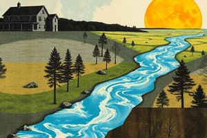
Water Cycle/Hydrological Cycle
- Natural recycling of water between the ocean, atmosphere, and land.
- It consists of stores and transfers/flows.
- Is a closed system with a fixed amount of water that is neither added nor lost.
Processes in the Water Cycle
- Stores
- Transfers/flows
Stores in the Water Cycle
- Places where water is held.
- Waterbodies: oceans, seas, lakes, and rivers.
- Atmosphere: water exists as vapor or droplets in clouds.
- Vegetation (interception): water held by tree leaves after rainfall.
- Rocks: groundwater stored in bedrock aquifers.
Transfers/Flows in the Water Cycle
- The movement of water between stores.
- Evaporation: water converts from liquid to gas (water vapor) due to the sun's heat.
- Transpiration: plants take up liquid from the soil and release it as water vapor into the atmosphere.
- Evapotranspiration: moisture loss from the ground by direct evaporation from waterbodies or soil, plus plant transpiration.
- Condensation: atmospheric water vapor cools and becomes liquid, forming clouds.
- Precipitation: water transfers from the atmosphere to the land or sea in any form (rain, hail, or snow).
- Overland flow/surface runoff: water moves horizontally over the saturated soil surface, eventually entering a stream, river, or lake.
- Infiltration: vertical transfer of water through soil pores from the surface.
- Percolation: vertical transfer of water through rock spaces into the aquifer or groundwater store.
- Throughflow: horizontal movement of water through the soil until it reaches a stream/river.
- Groundwater flow: horizontal movement of water in rocks of the aquifer, ultimately reaching a stream, river, or sea.
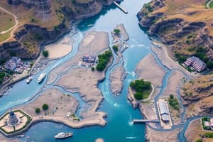
Drainage Basin Features
- Drainage Basin/Catchment Area is an area of land drained by a main river and its tributaries.
- Watershed/River Divide is a ridge of land that separates adjacent drainage basins.
- Drainage/Channel Network is a system of surface and underground channels that collect and transport precipitation within the drainage basin.
- Drainage Density is the total length of all streams and rivers in a drainage basin divided by the total area of the drainage basin.
- Source is the point where a river starts or originates.
- Tributaries are small streams which flow into the main river.
- Confluence is a point where tributaries join the main river.
- Mouth is a point where a river enters an ocean/sea.
Drainage Basin System
- A drainage basin is an open system where water is added from various sources and lost using various ways.
- Water amount varies over time.
- Composed of Inputs and Outputs
Inputs of a Drainage Basin
- Energy from the sun
- Precipitation formed from moisture picked up outside the basin.
- Water from tributary drainage basins
Outputs of a Drainage Basin
- River's discharge
- Water loss through evaporation and transpiration.
- This water eventually falls as precipitation in another drainage basin.
River Regimes/Hydrographs
- River regime is a seasonal variation in river discharge.
- River discharge measures water volume carried at any time (cubic meters per second).
- Hydrographs graph river discharge over a given time.
Factors Affecting River Regime
- The type of rock making up individual basins influences discharge.
- Impermeable rocks reduce percolation and increase surface runoff.
- Water reaches the river faster, leading to a high discharge.
- Permeable rocks increase percolation and decrease surface runoff.
- Water is delayed in reaching the river results a low discharge.
- Areas with steep slopes increase surface runoff but reduce infiltration.
- Water reaches the river faster causing high discharge.
- Gentle slopes decrease surface runoff while increasing infiltration.
- Water is delayed in reaching the river, resulting in low river discharge.
- Areas covered by tarmac and concrete reduce percolation increasing surface runoff.
- Water reaches rivers more quickly, leading to a high discharge.
- Forested areas increase interception and reduce surface runoff.
- Water reaching the river is delayed, leading to low discharge.
- Dams/reservoirs regulate river discharge by holding back water.
- High discharge is regulated to create a lower discharge downstream, reducing the risk of flooding downstream.
- High rainfall reduces infiltration because the soil is saturated, increasing surface runoff.
- Water reaches the river faster, resulting in high discharge.
- High temperatures increase the melting of ice in arctic regions.
- Melted water reaches the river faster, causing high discharge.
Hydrographs
- Records changing river discharge after rain.
- A hydrograph displays data on a river regime.
- Includes peak discharge, level of water discharge, stormflow, rising limb, falling limb, base flow
Hydrograph Structure
- Limb: the rising shows a river's discharge after rainfall leading to flooding.
- Falling Limb shows the discharge decrease after a rain subsides.
- Lag Time measures the difference between peak discharge and rainfall of a river.
- River with short lag time has high discharge because water reaches it faster.
- Rivers with a longer lag time has low discharge because water reaching is delayed.
- Flows: Represent the storm hydrograph discharge as two flows.
- Base flow is the normal river discharge.
- Storm flow is the additional discharge caused by rain.
Factors Affecting Lag Time
- Rock type and geology: Impermeable rocks reduce percolation and increased runoff lead to shorter lag times, whilst permeable rocks increase it and cause longer lag times
- Relief/slope: Steep slopes cause shorter lag times, while gentle increase it
- Urbanization/land use: Areas covered tarmac cause greater surface runoff and shorter lag times
- Vegetation(Interception): Forested areas increase interception and longer lag times
- Dams/reservoirs: Regulate the discharge of a river and cause longer lag times
- Climate high rainfall: less lag time
- Temperature: less lag time
Weathering and Mass Movement
- Breakdown of earth surface rocks by natural processes (in situ without movement)
- Mass movement is its movement of weathered materials down a slope caused by gravity.
Types of Weathering
- Physical weathering (exfoliation, freeze thaw)
- Biological weathering (plant action, animal action, human activities)
- Chemical weathering (oxidation, carbonation)
Physical Weathering
- The breakdown of rocks to smaller particles by changes in temperature and rainfall (climatic factors).
- Occurs in two ways: exfoliation and freeze thaw.
- Exfoliation occurs in warm climates when rocks are exposed to repeated heating and cooling.
- During the daytime surface layer the rocks are heated by the sun (expand).
- During night time the surface layer of rocks are cooled (contract).
- Repeated expansion and contraction erodes the outer layers of rocks
- Freeze-thaw occurs in mountainous regions.
- Water (rainfall) enters cracks during warm days and freezes during the coldness of night.
- The water converts to ice (expands) and causes pressure breaking rocks leading to smaller rocks.
Biological Weathering
- The breakdown of rocks into smaller particles by the action of living things.
- Plant action occurs by plant roots (especially trees) growing into rocks gradually splitting rock apart.
- Human activities include explosives in mining area which cause the breakdown of rocks.
Chemical Weathering
- The rocks breakdown to by chemical reactions.
- Oxidation occurs in rocks with iron (Fe) which bonds with oxygen and erodes it
- Carbonation dissolves limestone by weak carbonic acid rainfall.
Mass Movements Types
- Soil Creep-is where weathered materials move slowly down a gentle slope and collect at bottom.
- Slumping occurs when the bottom of an earth slope is cut away by a river, making it unstable causing weathered materials to slump towards the river
River Processes
- A river works in three different ways.
- River erosion
- River transport
- River Deposition
River Erosion
- Wearing away of river bed/bank by water force.
- Vertical erosion increases a river bed depth due to forces of water.
- Lateral erosion increases a river bank via discharge.
- Headward erosion lengthens a river as continual erosion occurs in a softer rock.
- Hydrauic action is which sheers water force dislodges bed and bank material and carries it away. It occurs during high river discharge.
- Abrasion material is carried by a river and wrapped against a riverbed bank widening and deepening channels.
- Corrosion (solution) minerals in sites are dissolved rocks as water flows past limestone.
- Attrition occurs as it particles become rounder and small during river journeys.
River Transport
- Movement of material (the load).
- Load is material worn or fallen into rivers, and can include boulders, pebbles or wood.
- Traction is the transporting of large boulders which are rolled on the river bed.
- Saltation transports small bounces along the river bed.
- Suspension occurs where material is carried along the river's flow.
- Solution occurs where is dissolved and carried by the water.
River Deposition
- The depositing of material transported by rivers, which commonly occurs in its lower course.
- Occurs where a enters a lake or sea with influenced by factors.
- A river volume decrease.
- River gradient decrease.
- Flow, Decrease in river speed.
- With decreasing capacity, Channel's overloading.
River Landforms
- Changes are associated with a rivers profile.
- Long profile from source to mouth.
- Cross profile change from bank to bank.
- Upstream and downstream changes associates with landforms
- Landforms divided upper course and lower course.
Upland Landforms
- They occur are formed by erosion with locations like a V-shaped valley with interlocking spurs, water falls, and Gorges.
- V-shaped Valleys created when a river eroded its valley through vertical.
- Erosion- vertical erosion leads to steep sides, valley. Valley deepening comes from abrasion and hydro action.
- Interlocking Spurs are formed when rivers moves from side.
Waterfall
- Waterfall can occur river flows over of rocks.
- A "sofrer" rock with force, where water forms underneath with hydraaion.
- Gorge forms when water falls with a process called retreat, further cutting upstream, and creating the narrow, sided steep.
- Advantages is hydroelectric power. And the tourism.
- Disadvantages is that they're high risk. And can stop a ships navigation.
Land Form, Lower
- Its occurs when stream velocity starts lower.
- Deposition occurs in of the lower river.
- A levee is a flood plain with sides.
- Ox bowlake occur stream on bends force water on outsidewith spiral flows.
- Delta occurs where there of channels. It means a high river stream occurs, because it carries sediment.
Flooding
- Occurs when a high discharge bursts across its bank.
- Results from two sources: high rainfall or melting of ice in areas.
Physical Factors Affecting Floods
- Rock-type(geology) impermeable rocks reduce percolation and increases the rate of water run-off.
- Heavy rainfall also reduces infiltration because soil water is reduced- this causes high discharge.
- Relief- steep slopes reduce infiltration that causes the water river to burst.
- Soil Clay soil is highly saturated after a rainstorm that causes a water river burst. Also increases runoff because soil
- Vegetation means the rate of vegetation causes run-off causes higher high run-off.
- High density, is why streams has many which which rain means they increase the rate run-off
- Temperature high temperature is melting of ice.
Human Factors causing floods
- The cutting down of trees causes reduces the amount of interception.
- Areas covered, reduces high. runoff and causes high flood.
- Agriculture, causes water burst.
Flood Effects
- Economic which cost and damages.
- Social with homes lost.
- Environment with biodiversity loss.
Prevention
Construction/Hard engineering. Expensive and are all structures to help reduce likelihood.
- Building of dam, which control control high storm.
- Building of embankment rising banks side more water. Deeper in reverse.
- Deep stream deeper more, with water.
Soft Engineering Mitigations
Flood can still be used with high grounds for, with floods. Afforestation planting tree causes interception in discharge. Land management stops buildings. All urban surfaces build a forest water.
Prediction
Risks assessents to help protect. • Environmental Monitor whether it is And river, rainfall etc. • And send information on the internet,.
Water uses
- Deman and supply.
- Only three of. all. What is on. Earth, is fresh. With the rest of us.
- Glaciers is 75.
- The remaining 20. is underground.
Domestic used for
- Household and garden uses
Industry uses
- Electricity production
Agricultural uses
- Livestock, growing of crop.
Leisure use
- Sailing,. On rivers, and ponds
Demand for water
- How amount is use which, Is reflection of of. is used how of water and what range.
Industrial development factor
- The machine of, water cooling
- Electriatal use.
Agricultural factor
What, water, that is use for irrigation.
Recreational Activities factor
Has, been in use for course sports like, swim etc..
Rise in of living
- Home how type the the pipes water
In the future of pouplations
- More, demand
Meeting of demand factors
- Water use etc.
- Like lake is.
- Used for drinking
Distribution water geographical.
Defiant, areas, is where water demand exceeded in high area, so their in place high is area in is deficit or nearful.
Water Quality and pollution
- Various use to maintain sustain
Climent contitions factor
- Where area is climate in quality
Pollution factors also
- Gratenity the lever the the the city
Sources in pollution
- Liquid, like farm water
Industry pollutions
Taking high heat heat back in rivers
Domesttic pollutions
Like of water the sea
Manging way
- Involves 3 stages
3 collection stage
Rivers.
- Resviors Aquafers.
Treatment
- Involves process to remover pollution with the raw for consumption
Subsances remoned
- Includes soils, Bacteria viruses minerals, chemicals
Chorinations types stages.
- Control growths, aeration,. Dissolver. Manganessm. Disinterations, to remover finer. Filters etc, to hill bacteria,,
Deliveries
Types Types way
By Pipes to consumption like for home, By Sprandpipes.
New ways
New wave plastic is of deliverin to make cheap cost
River Management
- Rivers manging lesseons and where from what origin
Spain
- A medium Is that most irt for falls in
China Management
- The three gorges
There is a high dam.
185 feet high
Benerits
- A flood protection
The. the . High energy electrical . power .
That reducers dependence coal
There is a high impovements
What is ships more better.
There is a high in torirsm
- To atrract tourisum
Higher in irrigatins
- The plant is high water
DIsavdnatges economic
- Is the the. high budhet
The People
- the , what can go wrong
China is big to handle water and soil
The is what water that is
The economic
- A in what china to and, of a trade What is from east east.
- And etc but the aintment the best.
Wealth Risk types
- High use high
Term 2
- Economic Activity and Energy study notes
Meaning of Terms Defined:
- Economic Sector: Major division of the economy with primary, secondary, tertiary, and quaternary sectors.
- Global Shift: The manufacturing movement from HICs to lower-cost LICS locations.
- Globalization: the process of the world economies being gradually connected through global interconnected organizations.
Types of Sectors defined:
- Economic activities grouped by production and job offer which offer three things:
- Creates jobs (employment)
- Generates income (wealth)
- Produces goods for sacel consumption.
Sectors Classified:
- Primary Sector involves raw materials like Farming, forestry, fishing
- Secondary Sector involves manufacturing and assembling into finished goods
- Tertiary Sector involves public services like transport, retail, medicine,
- Quaternary Sector provides specialized, concerned the ICT , design, management
Economic Shift: In Details
- Sector overtime, the population changes as primary decreases, and increase etc.. This causes quaternary.
- The figure shows a shift for the years.
Phases Shown:
- A pre the leading to , high population. And the source activity also.is highest. I 2) Industrial phase with high a , in relatie peak during, better .workforce
Studying That Suits You
Use AI to generate personalized quizzes and flashcards to suit your learning preferences.