Podcast
Questions and Answers
What is the main focus of thematic maps?
What is the main focus of thematic maps?
Specific theme or subject, often statistical data
Which government agencies in the Philippines are involved in creating topographic maps?
Which government agencies in the Philippines are involved in creating topographic maps?
Bureau of Lands and Ministry of Natural Resources
How have electronic computers revolutionized map-making?
How have electronic computers revolutionized map-making?
Replaced manual drafting with faster and more varied production methods
What is the purpose of symbols on topographic maps?
What is the purpose of symbols on topographic maps?
What is the flexibility provided by computer-generated maps?
What is the flexibility provided by computer-generated maps?
What is the origin of the word 'map'?
What is the origin of the word 'map'?
What is the main difference between planimetric and topographic maps?
What is the main difference between planimetric and topographic maps?
How do planimetric maps help users?
How do planimetric maps help users?
What type of information do planimetric maps lack?
What type of information do planimetric maps lack?
List the classifications of maps mentioned in the text.
List the classifications of maps mentioned in the text.
Flashcards are hidden until you start studying
Study Notes
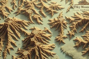
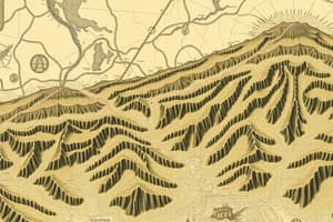
Topography and Maps
- Topography encompasses all identifiable surface features, natural or artificial, with positions relative to elevation above or below a reference datum.
- Topographic maps use symbols to depict hills, valleys, streams, and human-made structures.
Topographic Maps
- Topographic maps aid in engineering design, resource development, and military planning.
- Government agencies, such as the Bureau of Lands and Ministry of Natural Resources in the Philippines, create topographic maps to meet specific needs.
Thematic Maps
- Thematic maps focus on a specific theme or subject, typically overlaid on a skeletal topographic background.
- They present data, often statistical, in map form rather than graph form, emphasizing topics like geology, population, crop production, land use, or meteorological data.
- Thematic maps vary widely in scale and are not restricted by it, though they are typically medium to small in scale.
- They prioritize data classification and representation through abstract symbolism.
Computer-generated Maps
- Electronic computers have revolutionized map-making, replacing manual drafting with faster and more varied production methods.
- They process digital cartographic information, including survey data, scale, and contour intervals, to generate maps automatically.
- Interactive drafting systems enable operators to visualize and modify maps in real-time for accuracy and completeness before printing the final product.
- Advantages of computer-generated maps include:
- Faster and more accurate cartographic tasks
- Electronically stored data for convenience and easy retrieval
- Flexibility in resizing maps
- Minimized errors and mistakes
Maps and their Classification
- The word "map" originates from the Latin "mappa," meaning napkin or sheet.
- Maps can be classified into:
- Planimetric maps
- Topographic maps
- Thematic maps
- Computer-generated maps
- Photomaps
Planimetric Maps
- Planimetric maps represent the Earth's surface in two horizontal dimensions without showing elevations.
- They accurately depict the horizontal positions of natural and man-made features like buildings, roads, water bodies, and political boundaries.
- Planimetric maps are helpful for:
- Locating places
- Measuring distances
- Finding directions
Studying That Suits You
Use AI to generate personalized quizzes and flashcards to suit your learning preferences.