Podcast
Questions and Answers
Map projections have no distortions and are entirely accurate representations of the earth's surface.
Map projections have no distortions and are entirely accurate representations of the earth's surface.
False (B)
Digital elevation models (DEMs) are primarily derived from satellite imagery.
Digital elevation models (DEMs) are primarily derived from satellite imagery.
False (B)
Mercator and conic projections are examples of different types of map projections.
Mercator and conic projections are examples of different types of map projections.
True (A)
Understanding topography is essential for planning transportation routes to use the terrain effectively.
Understanding topography is essential for planning transportation routes to use the terrain effectively.
Digital topography maps are less efficient than traditional paper maps in analysis.
Digital topography maps are less efficient than traditional paper maps in analysis.
Topography maps use contour lines to represent points of unequal elevation.
Topography maps use contour lines to represent points of unequal elevation.
Closed contour lines can indicate either hills or depressions.
Closed contour lines can indicate either hills or depressions.
Contour lines crossing each other always indicate a gentle slope.
Contour lines crossing each other always indicate a gentle slope.
Index contours on a map are marked with lighter lines compared to regular contour lines.
Index contours on a map are marked with lighter lines compared to regular contour lines.
Contour line spacing affects the interpretation of slope steepness.
Contour line spacing affects the interpretation of slope steepness.
Topography maps are not useful for military planners.
Topography maps are not useful for military planners.
Contour intervals represent the difference in elevation between adjacent contour lines.
Contour intervals represent the difference in elevation between adjacent contour lines.
V-shaped contour patterns can represent peaks in the terrain.
V-shaped contour patterns can represent peaks in the terrain.
Flashcards
Map Projections
Map Projections
Different ways of representing a 3D Earth on a 2D map, each with varying distortions.
Digital Topography Maps
Digital Topography Maps
Maps showing Earth's surface elevation using digital models derived from data like LiDAR and photos.
Map Projection Choice
Map Projection Choice
Selecting the right projection depends on the mapped earth region to minimize distortions.
Practical Uses for Topography
Practical Uses for Topography
Signup and view all the flashcards
DEMs (Digital Elevation Models)
DEMs (Digital Elevation Models)
Signup and view all the flashcards
Topography Map
Topography Map
Signup and view all the flashcards
Contour Lines
Contour Lines
Signup and view all the flashcards
Contour Interval
Contour Interval
Signup and view all the flashcards
Contour Lines never
Contour Lines never
Signup and view all the flashcards
Closed Contour Lines
Closed Contour Lines
Signup and view all the flashcards
Steep slope on a map
Steep slope on a map
Signup and view all the flashcards
Gentle Slope a map
Gentle Slope a map
Signup and view all the flashcards
Index Contours
Index Contours
Signup and view all the flashcards
Study Notes
Defining Topography Maps
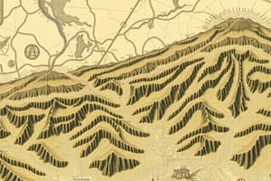
- Topography maps are two-dimensional representations of a three-dimensional surface, typically a portion of Earth's surface.
- They depict the elevation, shape, and features of terrain using contour lines.
Contour Lines
- Contour lines are lines connecting points of equal elevation on a map.
- They indicate the shape and steepness of the terrain.
- Contour intervals represent the difference in elevation between adjacent contour lines. A consistent interval is important, so the map is not ambiguous.
- Contour lines never cross unless depicting a vertical cliff.
- Closed contour lines form closed shapes, representing hills or depressions.
- Contour lines close together portray steep slopes.
- Widely spaced contours indicate gentle slopes.
Importance of Topography Maps
- Used by geologists to study the formation and structure of land.
- Used by engineers for designing roads, bridges, tunnels, and buildings. Necessary for navigating slopes to maximize and maintain stability.
- Used by military planners to understand strategic locations.
- Helpful for hikers and outdoor recreationists.
- Critical for understanding drainage patterns.
Major Map Components
- Contour lines: These connect points of equal elevation.
- Index contours: Heavier contour lines identify elevation values and provide reference for other lines.
- Relief: Shows the difference in elevation between high and low points on a map.
- Map scale: Shows the relationship between map distance and ground distance.
- Legend/Key: Explains symbols, colors, and other features used on the map.
- Location information: Latitude, longitude, and other coordinates are essential.
- Datum: The elevation reference point (e.g., mean sea level).
Interpretation of Topography Maps
- Contour spacing and shape reveal slope characteristics.
- Closely spaced contours indicate steep slopes; wide spacing, gentle slopes.
- V-shaped contour patterns indicate valleys.
- Contour lines forming closed loops may represent hills or depressions.
Applications in Different Fields
- Civil Engineering: Calculating earthwork volumes, designing roads and tunnels based on terrain.
- Geology: Studying geological structures, understanding drainage patterns and erosion processes.
- Geography: Visualizing and analyzing landforms (mountains, valleys, plains).
- Military Planning: Determining strategic locations, understanding visibility, and planning troop movement.
Map Projections
- Different map projections exist, each with distortions. Understanding the projection is crucial for correct interpretation.
- Projection choice depends on the mapped region, minimizing distortions in the area of interest.
- Mercator, conic, and planar are examples of map projections. Proper analysis is needed based on the location on Earth.
Digital Topography Maps
- Modern technology uses digital elevation models (DEMs) from data like LiDAR and aerial photography.
- Digital versions enable more detailed and complex analyses.
- Digital topography maps offer greater efficiency.
Using Topography Maps for Practical Purposes
- Calculating the minimum grade for pipe installations.
- Analyzing drainage patterns for potential flooding.
- Planning transportation routes that exploit terrain.
- Understanding terrain before building or designing roads.
Studying That Suits You
Use AI to generate personalized quizzes and flashcards to suit your learning preferences.