Podcast
Questions and Answers
What does the numerator in a representative fraction (RF) always denote?
What does the numerator in a representative fraction (RF) always denote?
- Ground distance
- Map distance (correct)
- The level of detail
- The total area represented
A map with a representative fraction of 1:100,000 is considered a large-scale map compared to a map with an RF of 1:1,000.
A map with a representative fraction of 1:100,000 is considered a large-scale map compared to a map with an RF of 1:1,000.
False (B)
If a map has a representative fraction of 1:50,000, what does this imply about the relationship between distances on the map and the real world?
If a map has a representative fraction of 1:50,000, what does this imply about the relationship between distances on the map and the real world?
One unit on the map represents 50,000 units on the ground.
A map scale can be represented by text, a graphic, or some ______ of the two.
A map scale can be represented by text, a graphic, or some ______ of the two.
Which of the following statements best describes the relationship between map scale and the level of detail shown on a map?
Which of the following statements best describes the relationship between map scale and the level of detail shown on a map?
Match the map scale representation with its description.
Match the map scale representation with its description.
Why is the representative fraction (RF) scale considered unit-neutral?
Why is the representative fraction (RF) scale considered unit-neutral?
Online maps and GIS maps are considered truly 'scaleless' because of the ability to zoom in and out.
Online maps and GIS maps are considered truly 'scaleless' because of the ability to zoom in and out.
Which analytical geographical question is primarily addressed through the consideration of space?
Which analytical geographical question is primarily addressed through the consideration of space?
Spatial thinking involves analyzing the arrangement of a limited number and variety of phenomena across space.
Spatial thinking involves analyzing the arrangement of a limited number and variety of phenomena across space.
What term refers to the skill required to analyze and understand the arrangements of a large number and variety of phenomena across space on the Earth?
What term refers to the skill required to analyze and understand the arrangements of a large number and variety of phenomena across space on the Earth?
The arrangement of phenomena across space is referred to as their spatial ______, which can be expressed with reference to properties such as density, concentration, and pattern.
The arrangement of phenomena across space is referred to as their spatial ______, which can be expressed with reference to properties such as density, concentration, and pattern.
Match the concept with its correct description:
Match the concept with its correct description:
Which of the following is NOT a characteristic considered when defining a 'place'?
Which of the following is NOT a characteristic considered when defining a 'place'?
Every place in the world shares identical physical and human characteristics.
Every place in the world shares identical physical and human characteristics.
What are the three properties that can be used to express spatial distribution?
What are the three properties that can be used to express spatial distribution?
Why is the human-environment relationship an important focus of geographical research?
Why is the human-environment relationship an important focus of geographical research?
The concept of "place" helps geographers to ______ and contrast different locations on Earth, such as Antarctica and the Sahara Desert.
The concept of "place" helps geographers to ______ and contrast different locations on Earth, such as Antarctica and the Sahara Desert.
If 0.5 cm on a map represents 500 km in the real world, what ratio scale represents 1 cm on the map?
If 0.5 cm on a map represents 500 km in the real world, what ratio scale represents 1 cm on the map?
A relative location provides geographical coordinates.
A relative location provides geographical coordinates.
What is the primary difference between absolute and relative location?
What is the primary difference between absolute and relative location?
The amount of separation between locations, measured in either relative or absolute terms, is known as ______.
The amount of separation between locations, measured in either relative or absolute terms, is known as ______.
Match the following terms with their correct descriptions:
Match the following terms with their correct descriptions:
When converting a word scale to a ratio scale, what is an important step to remember?
When converting a word scale to a ratio scale, what is an important step to remember?
Direction can only be determined using true north as a benchmark.
Direction can only be determined using true north as a benchmark.
Explain the concept of 'space-time compression'.
Explain the concept of 'space-time compression'.
A ________ ________ is a reference point used to determine direction.
A ________ ________ is a reference point used to determine direction.
Which factor primarily influences 'space-time compression'?
Which factor primarily influences 'space-time compression'?
Absolute distances are based on opinion and experience.
Absolute distances are based on opinion and experience.
Give an example of how distance can be measured in relative terms.
Give an example of how distance can be measured in relative terms.
The geographic coordinates of a location provide its _______ location.
The geographic coordinates of a location provide its _______ location.
What does location refer to in the field of geography?
What does location refer to in the field of geography?
Match the scales with its description
Match the scales with its description
Before the late nineteenth century, how was time primarily determined?
Before the late nineteenth century, how was time primarily determined?
Traveling westward from the Prime Meridian, you should adjust your clock forward.
Traveling westward from the Prime Meridian, you should adjust your clock forward.
Briefly explain the difference between absolute and relative distance.
Briefly explain the difference between absolute and relative distance.
The Prime Meridian is crucial for determining time as it serves as the zero-degree line of ________.
The Prime Meridian is crucial for determining time as it serves as the zero-degree line of ________.
Match each time-related term with its correct description:
Match each time-related term with its correct description:
What is the rate at which the Earth rotates in one hour?
What is the rate at which the Earth rotates in one hour?
'Site' refers to the external relations of a place, including its location relative to other places.
'Site' refers to the external relations of a place, including its location relative to other places.
Define what geographers mean by 'space' and provide an example.
Define what geographers mean by 'space' and provide an example.
When we say that 'place' is socially __________ , we mean that the characteristics and meanings we ascribe to a location are influenced by human perception and values.
When we say that 'place' is socially __________ , we mean that the characteristics and meanings we ascribe to a location are influenced by human perception and values.
Match each type of region with its description:
Match each type of region with its description:
Which factor contributes to distance being less of an obstacle for interaction between places today compared to the past?
Which factor contributes to distance being less of an obstacle for interaction between places today compared to the past?
Regions are static entities with fixed boundaries that never change.
Regions are static entities with fixed boundaries that never change.
What is the effect of space-spanning connections and flows of information on the rootedness of processes?
What is the effect of space-spanning connections and flows of information on the rootedness of processes?
The concept of 'situation' refers to a location's importance based on its __________ context and connections to other places.
The concept of 'situation' refers to a location's importance based on its __________ context and connections to other places.
Which concept is most associated with measurement, as opposed to meaning?
Which concept is most associated with measurement, as opposed to meaning?
Flashcards
Map Scale
Map Scale
The factor by which the world is reduced to fit on a map.
Line Scale
Line Scale
A graphic representation of map scale, used to approximate distances.
Representative Fraction (RF)
Representative Fraction (RF)
A scale expressed as a ratio where the numerator (1) represents map distance and the denominator represents ground distance.
Calculating RF
Calculating RF
Signup and view all the flashcards
RF: Unit Neutral
RF: Unit Neutral
Signup and view all the flashcards
Large-Scale Map
Large-Scale Map
Signup and view all the flashcards
Small-Scale Map
Small-Scale Map
Signup and view all the flashcards
Multiscalar
Multiscalar
Signup and view all the flashcards
Understanding of Place
Understanding of Place
Signup and view all the flashcards
Space in Geography
Space in Geography
Signup and view all the flashcards
Place in Geography
Place in Geography
Signup and view all the flashcards
Human-Environment Relationship
Human-Environment Relationship
Signup and view all the flashcards
Spatial Distribution
Spatial Distribution
Signup and view all the flashcards
Properties of Spatial Distribution
Properties of Spatial Distribution
Signup and view all the flashcards
Place
Place
Signup and view all the flashcards
Toponymy
Toponymy
Signup and view all the flashcards
Site
Site
Signup and view all the flashcards
Situation
Situation
Signup and view all the flashcards
Ratio Scale
Ratio Scale
Signup and view all the flashcards
Word Scale
Word Scale
Signup and view all the flashcards
Location
Location
Signup and view all the flashcards
Absolute Location
Absolute Location
Signup and view all the flashcards
Relative Location
Relative Location
Signup and view all the flashcards
Direction
Direction
Signup and view all the flashcards
Grid North
Grid North
Signup and view all the flashcards
Parallels
Parallels
Signup and view all the flashcards
Meridians
Meridians
Signup and view all the flashcards
Important Parallels
Important Parallels
Signup and view all the flashcards
Great Circles
Great Circles
Signup and view all the flashcards
Small Circles
Small Circles
Signup and view all the flashcards
Distance
Distance
Signup and view all the flashcards
Space-Time Compression
Space-Time Compression
Signup and view all the flashcards
Pre-19th Century Time
Pre-19th Century Time
Signup and view all the flashcards
Time Zone Development
Time Zone Development
Signup and view all the flashcards
Prime Meridian & Date Line
Prime Meridian & Date Line
Signup and view all the flashcards
Earth's Rotation
Earth's Rotation
Signup and view all the flashcards
Clock Adjustments
Clock Adjustments
Signup and view all the flashcards
Absolute vs. Relative Distance
Absolute vs. Relative Distance
Signup and view all the flashcards
Reduced Distance Obstacle
Reduced Distance Obstacle
Signup and view all the flashcards
Space vs. Place
Space vs. Place
Signup and view all the flashcards
Geographic Space
Geographic Space
Signup and view all the flashcards
Geographic Place
Geographic Place
Signup and view all the flashcards
Social Construction of Place
Social Construction of Place
Signup and view all the flashcards
Region
Region
Signup and view all the flashcards
Geographic Space
Geographic Space
Signup and view all the flashcards
Study Notes
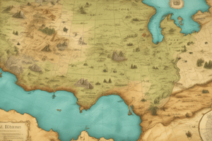
Map Scale
- Map scale is the factor by which the world is reduced to fit on a map.
- Scale can be represented by text (e.g., "one centimetre represents ten kilometres"), a graphic line scale, or a representative fraction (RF).
- Line scales are typically found on reference maps to help estimate distances.
- Representative Fraction (RF) expresses scale as a ratio (e.g., 1:10,000), where 1 unit on the map represents 10,000 units on the ground.
- RF is unit neutral, so any unit of measure can be used.
- Large-scale maps (e.g., 1:1,000) show more detail over a smaller area, while small-scale maps (e.g., 1:1,000,000) show less detail over a larger area.
- GIS and online maps are multiscalar, allowing users to zoom in and out.
Location and Direction
- Location refers to a phenomenon's position on the Earth's surface and is a key concept in geography.
- Absolute location is given in geographical coordinates (e.g., 33°54′17”S; 18°26′02”E for Cape Town port).
- Relative location describes a place in relation to other features (e.g., Cape Town port is 2 km north of the CBD).
- Direction is the position of something relative to something else, requiring a reference point.
- Common benchmarks for direction include true north, magnetic north, and grid north.
Distance and Time
- Distance complements location and direction, measuring the separation between locations.
- Distance can be measured in relative terms (hours on a jet) or absolute terms (kilometers).
- Absolute distance metrics are favored for objective comparisons.
- Space-time compression refers to the reduction in the time it takes to travel between places due to rapid connections and telecommunications.
- Standardized benchmarks are required to make objective comparisons and support worldwide communication.
- Human perceptions of distance and time remain relative and depend on subjective factors.
Space, Place, and Region
- Space is about measurement, while place and region involve meaning in geographic relationships.
- Space refers to the relationship between locations based on their characteristics or phenomena.
- Place refers to the relationships among phenomena at distinctive locations, including human activities and environmental characteristics.
- Understanding place involves interpreting how these phenomena interconnect.
- Spatial thinking, the skill to analyze and understand arrangements of phenomena across space, is a key skill for geographers
- Region is a concept challenged by the increasing "placelessness" of the world due to space-spanning connections and flows.
Space vs. Place
- Space considers the distance between locations, patterns, and their scale.
- Place examines relationships among phenomena at specific locations, including human activities and environmental aspects.
- Space addresses "Where?", while place addresses "What is it like?", "Why?", and "To what effect?".
Space and Distribution of Phenomena
- Geographers study the arrangement of phenomena related to people, activities, natural features, and the environment across space.
- Spatial distribution refers to the arrangement of phenomena across space, expressed through density, concentration, and pattern.
Place as a Unique Location
- Place is interwoven with physical and human characteristics, including toponymy (place name), site (physical and human characteristics), and situation (location relative to other places).
- Each place has unique characteristics in terms of climate, landforms, human habitation, and cultures.
- The Sahara Desert hosts nomadic tribes, whilst Antarctica is cold and mostly void of people.
Studying That Suits You
Use AI to generate personalized quizzes and flashcards to suit your learning preferences.
Description
Explore map scales: text, graphic, and representative fractions. Learn about large-scale vs. small-scale maps and the importance of location. Delve into absolute and relative location in geography.