Podcast
Questions and Answers
Which terrestrial landscape is primarily found around the poles?
Which terrestrial landscape is primarily found around the poles?
- Hot deserts
- Tundra (correct)
- Boreal forests
- Tropical forests
What type of climate is typically found at ~30° latitude?
What type of climate is typically found at ~30° latitude?
- Cold and humid
- Hot and arid (correct)
- Hot and humid
- Cold and arid
Which of the following landscapes is most humid?
Which of the following landscapes is most humid?
- Grasslands
- Deserts
- Forests (correct)
- Steppes
Which sequence accurately describes the progression of terrestrial landscapes from humid to arid?
Which sequence accurately describes the progression of terrestrial landscapes from humid to arid?
During which season does the Northern Hemisphere experience more direct sunlight?
During which season does the Northern Hemisphere experience more direct sunlight?
What is the primary characteristic of climates at the equatorial latitudes?
What is the primary characteristic of climates at the equatorial latitudes?
Which landscape is typically found at ~60° latitude in the Northern Hemisphere?
Which landscape is typically found at ~60° latitude in the Northern Hemisphere?
What occurs due to the apparent motion of the Sun, affecting climate transition?
What occurs due to the apparent motion of the Sun, affecting climate transition?
What is the term used for the extensions of ice sheets over water?
What is the term used for the extensions of ice sheets over water?
Which part of a glacier is defined as the beginning located on a mountaintop?
Which part of a glacier is defined as the beginning located on a mountaintop?
Which of the following describes the phenomenon when the terminus of a glacier moves down the mountain?
Which of the following describes the phenomenon when the terminus of a glacier moves down the mountain?
What process results in the smoothing of rocks due to glacial movement?
What process results in the smoothing of rocks due to glacial movement?
What is the term for the boundary between the zones of accumulation and wastage in a glacier?
What is the term for the boundary between the zones of accumulation and wastage in a glacier?
What type of feature is a 'fjord' in glaciology?
What type of feature is a 'fjord' in glaciology?
Which of the following describes a large boulder that does not match the surrounding landscape?
Which of the following describes a large boulder that does not match the surrounding landscape?
What is the primary cause of glacial ablation?
What is the primary cause of glacial ablation?
Which factor is considered the primary variable affecting climate?
Which factor is considered the primary variable affecting climate?
What process involves the breaking down of existing landscapes without compositional changes?
What process involves the breaking down of existing landscapes without compositional changes?
Which of the following is NOT a recognized process in geomorphic agents?
Which of the following is NOT a recognized process in geomorphic agents?
What term describes the measure of acidity or basicity in a solution?
What term describes the measure of acidity or basicity in a solution?
Which soil horizon is characterized by organic litter?
Which soil horizon is characterized by organic litter?
What is the term for the degradation of one part of soil through the leaching process?
What is the term for the degradation of one part of soil through the leaching process?
Which type of mass wasting is characterized as the slowest form?
Which type of mass wasting is characterized as the slowest form?
Which of the following soil types is known for being the youngest?
Which of the following soil types is known for being the youngest?
What is the primary agent of degradation that alters landscapes through water movement?
What is the primary agent of degradation that alters landscapes through water movement?
What is the primary agent of geomorphic processes?
What is the primary agent of geomorphic processes?
Which of the following accurately describes perennial rivers?
Which of the following accurately describes perennial rivers?
Which soil productivity factor is considered the most crucial?
Which soil productivity factor is considered the most crucial?
What is the drainage divide?
What is the drainage divide?
How does river discharge typically change from the head to the mouth of a river?
How does river discharge typically change from the head to the mouth of a river?
What is the term for the maximum size load that a river can erode?
What is the term for the maximum size load that a river can erode?
Which type of rock layer is classified as nonporous and impermeable?
Which type of rock layer is classified as nonporous and impermeable?
What feature is described as an abrupt change in river gradient?
What feature is described as an abrupt change in river gradient?
What type of load refers to dissolved materials in a river?
What type of load refers to dissolved materials in a river?
Which process refers to water flowing through rock?
Which process refers to water flowing through rock?
Which type of aquifer is sandwiched between two aquitards?
Which type of aquifer is sandwiched between two aquitards?
Flashcards
Transitional Environment
Transitional Environment
The area where oceans and continents meet, characterized by a mix of marine and terrestrial features.
Equatorial Climate
Equatorial Climate
The region around the Equator, known for hot and humid conditions due to the equatorial low-pressure system.
Subtropical Climate
Subtropical Climate
Regions at approximately 30° latitude characterized by hot and arid conditions due to the subtropical high-pressure systems.
Subpolar Climate
Subpolar Climate
Signup and view all the flashcards
Landscape Progression
Landscape Progression
Signup and view all the flashcards
Midlatitude Seasons
Midlatitude Seasons
Signup and view all the flashcards
Equatorial Seasons
Equatorial Seasons
Signup and view all the flashcards
Polar Seasons
Polar Seasons
Signup and view all the flashcards
Geomorphology
Geomorphology
Signup and view all the flashcards
Geomorphic Agents
Geomorphic Agents
Signup and view all the flashcards
Degradation (Weathering)
Degradation (Weathering)
Signup and view all the flashcards
Erosion
Erosion
Signup and view all the flashcards
Aggradation
Aggradation
Signup and view all the flashcards
Mechanical Weathering
Mechanical Weathering
Signup and view all the flashcards
Chemical Weathering
Chemical Weathering
Signup and view all the flashcards
pH
pH
Signup and view all the flashcards
Regolith
Regolith
Signup and view all the flashcards
Soil
Soil
Signup and view all the flashcards
Hydrologic Cycle
Hydrologic Cycle
Signup and view all the flashcards
Watercourse
Watercourse
Signup and view all the flashcards
Tributary
Tributary
Signup and view all the flashcards
Distributary
Distributary
Signup and view all the flashcards
Watershed/Drainage Basin
Watershed/Drainage Basin
Signup and view all the flashcards
Drainage Divide
Drainage Divide
Signup and view all the flashcards
River Gradient
River Gradient
Signup and view all the flashcards
River Discharge
River Discharge
Signup and view all the flashcards
River Load
River Load
Signup and view all the flashcards
River Competence
River Competence
Signup and view all the flashcards
Cryosphere
Cryosphere
Signup and view all the flashcards
Alpine Glaciers
Alpine Glaciers
Signup and view all the flashcards
Continental Ice Sheets
Continental Ice Sheets
Signup and view all the flashcards
Ice Age
Ice Age
Signup and view all the flashcards
Nunataks
Nunataks
Signup and view all the flashcards
Ice Shelves
Ice Shelves
Signup and view all the flashcards
Ice Floes
Ice Floes
Signup and view all the flashcards
Glacier Formation
Glacier Formation
Signup and view all the flashcards
Study Notes
Terrestrial Environments
- Earth's landscapes are categorized as terrestrial (on continents), marine (ocean floor), and transitional (shores).
- Marine environments cover most of Earth's surface.
- The study focuses on terrestrial environments.
Climate and Terrestrial Environments
-
Temperature and Humidity:
- The equator is hot and humid due to the equatorial low pressure.
- Areas around 30° latitude are hot and arid due to subtropical highs.
- Regions around 60° latitude are cold and humid due to subpolar lows.
- Polar regions are cold and arid due to polar highs.
-
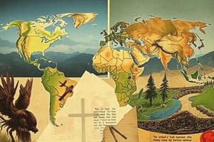
Terrestrial Landscapes by Latitude:
- The equator has tropical forests (Amazon, Congo, Indonesian rainforests).
- Around 30° latitude, hot deserts exist (Sahara, Arabian, Gobi, Great Australian).
- Northern hemisphere 60° latitude has boreal forests (taigas).
- Poles are permafrost areas covered with continental ice sheets (Antarctica, Greenland).
-
Progression of Terrestrial Landscapes (Humid to Arid):
- Landscapes range from humid forests to arid deserts, passing through woodlands, shrublands, grasslands, and steppes.
-
Landscape Progression by Latitude:
- Transitions illustrate the effect of latitude on climate and landscape. For example, from equator to deserts, tropical environments change to hot steppes and deserts.
-
Seasons:
- Mid-latitudes experience summer (more direct sunlight) and winter (less direct sunlight).
- Equatorial latitudes have a high-sun season and a low-sun season.
- Polar latitudes have a daytime season and a nighttime season, each lasting for half the year.
-
Shifting Climates: Climate factors like humidity and aridity shift with the Sun's apparent movement, influencing the boundaries between environments.
-
Factors Affecting Climate: Latitude is a primary factor; ocean currents, continental effects, and orographic effects are secondary factors.
-
Elevation and Latitude: Elevation changes on a mountain mimic the effect of latitude, showing a progression of landscapes from the base to the summit.
Geomorphology
- Definition: The study of how landscapes and environments change over time.
- Geomorphic Agents: Forces that reshape landscapes:
- Most significant: Fluvial processes (running water).
- Other agents: Wind, gravity, underground water, glaciers.
- Geomorphic Processes:
- Degradation (weathering): Breaking down landscapes.
- Erosion: Moving sediments.
- Aggradation: Building new landscapes with sediments.
Weathering
- Mechanical Weathering: Breakdown without compositional changes.
- Examples: Exfoliation, frost wedging, salt wedging.
- Chemical Weathering: Breakdown with compositional changes.
- Examples: Carbonation, oxidation, hydrolysis.
- Acids and Bases: Different theories define acids and bases (Arrhenius, Brønsted-Lowry, Lewis). pH measures acidity or basicity.
- Biological Weathering: Breakdown by living organisms.
- Differential Weathering: Uneven breakdown of different landscape parts. Examples: Inselbergs, volcanic necks.
Soil Science
- Regolith: Layer of sediment covering Earth's surface.
- Soil: A specific regolith type vital for agriculture.
- Pedosphere: All soils; an intersection of the geosphere, hydrosphere, atmosphere, and biosphere.
- Soil Composition: Inorganic minerals, water, air, and organic material.
- Sediment Size (Wentworth Scale): Sediments are categorized by size.
- Soil Texture: Soil texture is determined by inorganic mineral components.
- Coarse, fine, or intermediate (loam).
- Water in Soil: Forms of water in soil include free water, cohesive water, adhesive water, and combined water bound to soil.
- Soil Processes:
- Eluviation: Degradation of one part of the soil.
- Leaching: Erosion of degraded material.
- Illuviation: Aggradation from leached material.
- Soil Horizons: Layers of soil resulting from eluviation, leaching, and illuviation.
- Examples: O horizon, A horizon, B horizon, C horizon, and R horizon.
- Soil Productivity Factors:
- Parent material (composition).
- Climate (most important).
- Topography (slope).
- Bioturbation (soil mixing from life forms).
- Crop Rotation: Alternating crops to maintain soil health.
- Soil Taxonomy: Classification of soils into orders (Entisols, Andisols, etc.); the most agriculturally productive are Alfisols and Mollisols.
Mass Wasting
- Definition: Movement of material downhill due to gravity.
- Triggers: Heavy rain, snowmelt, earthquakes, fires, or steepened slopes.
- Angle of Repose: The maximum slope a given material can have without mass wasting.
- Types:
- Falls (fastest).
- Slides & Flows.
- Creep/Solifluction (slowest).
- Other Terms: Avalanche, Lahar, Talus slopes, and Escarpments (steep cliffs).
Fluvial Processes
- Hydrologic Cycle: The continuous movement of water.
- Watercourses: Rills, brooks, creeks, streams, and rivers; tributaries feed larger watercourses.
- Drainage Patterns: Dendritic, radial, rectangular, trellis, and interior.
- Rivers:
- Perennial rivers flow year-round.
- Ephemeral rivers are temporary.
- Watersheds/Drainage Basins, Drainage Divides, and Continental Divides.
- River Gradient: The vertical drop per horizontal distance decreases from the river head to mouth.
- River Discharge: The volume of water per unit time; typically increases from river head to mouth.
- River Load: Material (sediment) transported by a river.
- Bed load, suspended load, and dissolved/solution load.
- River Competence & Capacity: The river's ability to transport different-sized and total amount of material.
- Longitudinal Profile: Graph illustrating river gradient.
- Base Level: The river's lowest point.
- Downcutting, Waterfalls & Rapids, and Lateral Profiles: Concepts related to river erosion and channel formation.
- Floodplain Protection: Natural features, like levees.
- Flood Control: Techniques such as artificial levees and channelization. A major cause of flood deaths are car accidents.
Groundwater Processes
- Groundwater: Water beneath the Earth's surface.
- Porosity & Permeability: Properties of rocks that affect groundwater flow.
- Phreatic & Vadose Zones: Zones of saturated (phreatic) and unsaturated (vadose) ground.
- Water Table: The boundary between the water-saturated zone and the unsaturated zone.
- Aquifers & Aquitards: Layers through which groundwater flows easily or not.
- Confined Aquifers: Aquifers trapped between layers.
- Karst Topography: Landscapes shaped by groundwater (caverns, sinkholes, springs).
- Speleology & Speleogenesis: The study of caverns and how they form.
- Speleothems (cave formations): Stalactites, stalagmites, and columns.
Aeolian Processes
- Aeolian Processes: The movement of land surfaces by wind.
- Desert Composition: Includes hamadas (solid rock), regs (gravel), and ergs (sand).
- Aeolian Landforms: Ventifacts, yardangs, and the degradation of plateaus to mesas to buttes.
- Aeolian Load: Bed load (sand) and suspended load (silt).
- Aeolian Aggradation: Loess and dunes.
Glaciology
- Cryosphere: All ice on Earth.
- Glaciers: Alpine (mountain) and continental (ice sheets).
- Ice Age: A period with widespread glaciation.
- Glacier Formation: Stages of ice formation.
- Glacial Anatomy: Parts of a glacier. Example: Zone of Accumulation and Zone of Wastage.
- Glacial Movement: Advancing, retreating, and stationary.
- Glacial Weathering: Abrasion and plucking.
- Glacial Aggradation: Till and stratified drift.
- Moraines: Sediment deposits from glaciers (lateral, medial, end, and ground moraines).
- Post-Glacial Features: Tarns (glacial lakes) and paternoster lakes.
- Glacial landforms: V-shaped valleys becoming U-shaped valleys, Fjords, Arêtes, and Glacial Horns.
Studying That Suits You
Use AI to generate personalized quizzes and flashcards to suit your learning preferences.
Description
Explore the characteristics and climates of various terrestrial environments across different latitudes. This quiz covers the unique landscapes such as tropical forests, deserts, boreal forests, and polar regions. Test your knowledge on how temperature and humidity influence these environments.