Podcast
Play an AI-generated podcast conversation about this lesson
Download our mobile app to listen on the go
Get App
Questions and Answers
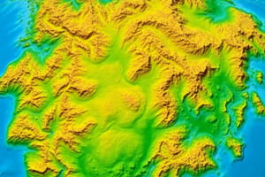
A geologic map is used to show the distribution of the earth's material.
A geologic map is used to show the distribution of the earth's material.
True (A)
Map units on a geologic map are represented by a unique name, abbreviation, and symbol.
Map units on a geologic map are represented by a unique name, abbreviation, and symbol.
False (B)
The correlation of map units on a geologic map shows their absolute age.
The correlation of map units on a geologic map shows their absolute age.
False (B)
The scale of a geologic map represents the actual size of geologic features.
The scale of a geologic map represents the actual size of geologic features.
Signup and view all the answers
Symbols on a geologic map are used to show the location of geological structures.
Symbols on a geologic map are used to show the location of geological structures.
Signup and view all the answers
Flashcards are hidden until you start studying
Study Notes
Interpreting Geologic Maps
- A geologic map is a visual representation of the distribution of the Earth's material
- The map is composed of different units, each representing a specific type of earth material, denoted by:
- Color: unique for each unit
- Name: abbreviated for easy identification
- Text: brief description of the material's characteristic
- The scale of the map is proportional to the actual size of the geologic features shown
Map Symbols and Correlation
- Symbols, diagrams, and names are used to represent different features on the map
- The correlation of map units shows the relative age of the material found in the map
Studying That Suits You
Use AI to generate personalized quizzes and flashcards to suit your learning preferences.