Podcast
Questions and Answers
What is the definition of an alluvial plain?
What is the definition of an alluvial plain?
- A group of islands that lie in fairly close proximity
- A stretch of water that has become bypassed by the main flow of a stream
- A level tract of land made up of alluvium or fine rock material brought down by a river (correct)
- The solid rock lying beneath soil and weathered material
What is the meaning of arid?
What is the meaning of arid?
- Composed of or containing a high proportion of calcium carbonate
- Denoting any climate or region in which the rainfall is insufficient or barely sufficient to support vegetation (correct)
- The boundary between land and sea
- The average weather conditions of a sizeable area of the earth’s surface over a period of time
What is the purpose of a biosphere reserve?
What is the purpose of a biosphere reserve?
- To provide facilities for education, awareness, and explaining
- To construct embankments for conserving water and soil
- To conserve and maintain diversity and integrity of natural heritage in its full form (correct)
- Composed of or containing a high proportion of calcium carbonate
What is the definition of bunding?
What is the definition of bunding?
What characterizes bedrock?
What characterizes bedrock?
What does climate represent?
What does climate represent?
What is the definition of an estuary?
What is the definition of an estuary?
What is the primary role of a National Park?
What is the primary role of a National Park?
What is the main characteristic of a glacier?
What is the main characteristic of a glacier?
What is the primary focus of conservation?
What is the primary focus of conservation?
Which landform results from a bend in rock strata due to crustal compression?
Which landform results from a bend in rock strata due to crustal compression?
What is characteristic of a gully erosion?
What is characteristic of a gully erosion?
What is the term for an elevated area of relatively flat land?
What is the term for an elevated area of relatively flat land?
Which landform is smaller than a continent and surrounded by water?
Which landform is smaller than a continent and surrounded by water?
What occurs in an area where a river bed suddenly becomes steeper?
What occurs in an area where a river bed suddenly becomes steeper?
What is the primary characteristic of humus?
What is the primary characteristic of humus?
What is the main objective of a Biosphere Reserve?
What is the main objective of a Biosphere Reserve?
Which term refers to a group of islands that lie in fairly close proximity?
Which term refers to a group of islands that lie in fairly close proximity?
What is the characteristic of a Backwater?
What is the characteristic of a Backwater?
What is the composition of Calcareous material?
What is the composition of Calcareous material?
Which action takes place in catchment areas?
Which action takes place in catchment areas?
What does an Alluvial Plain consist of?
What does an Alluvial Plain consist of?
What natural feature is mainly found in warm shallow sea water and forms coral reefs?
What natural feature is mainly found in warm shallow sea water and forms coral reefs?
In meteorology, what does 'depression' mainly refer to?
In meteorology, what does 'depression' mainly refer to?
What is the primary characteristic of a sanctuary?
What is the primary characteristic of a sanctuary?
What geological process is responsible for creating a fold in rock strata?
What geological process is responsible for creating a fold in rock strata?
What term is used to describe a deep valley with steep and rocky side walls?
What term is used to describe a deep valley with steep and rocky side walls?
What landform is characterized by a mass of snow and ice moving slowly away from its place of accumulation?
What landform is characterized by a mass of snow and ice moving slowly away from its place of accumulation?
What is the primary focus of a national park?
What is the primary focus of a national park?
What geological process creates a plateau?
What geological process creates a plateau?
What natural feature is known for being a coarse-grained metamorphic rock with a banded structure?
What natural feature is known for being a coarse-grained metamorphic rock with a banded structure?
Which term describes the tidal mouth of a river where fresh and saline water mix?
Which term describes the tidal mouth of a river where fresh and saline water mix?
Which term best describes a stretch of water that has been bypassed by the main flow of a stream, yet remains connected to it with a very low rate of flow?
Which term best describes a stretch of water that has been bypassed by the main flow of a stream, yet remains connected to it with a very low rate of flow?
What is the primary objective of a Biosphere Reserve?
What is the primary objective of a Biosphere Reserve?
Which term refers to a level tract of land composed of alluvium or fine rock material brought down by a river?
Which term refers to a level tract of land composed of alluvium or fine rock material brought down by a river?
What does the term 'Catchment Area' refer to?
What does the term 'Catchment Area' refer to?
What is the primary characteristic of an Arid climate?
What is the primary characteristic of an Arid climate?
Which term describes an area drained by a major river and its tributaries?
Which term describes an area drained by a major river and its tributaries?
What term is used to describe a mass of land that is surrounded by water and is smaller than a continent?
What term is used to describe a mass of land that is surrounded by water and is smaller than a continent?
Which landform is characterized by a bend in rock strata resulting from compression of an area of the earth’s crust?
Which landform is characterized by a bend in rock strata resulting from compression of an area of the earth’s crust?
What term is used to describe an extensive elevated area of relatively flat land?
What term is used to describe an extensive elevated area of relatively flat land?
In meteorology, what does 'jet stream' refer to?
In meteorology, what does 'jet stream' refer to?
What term refers to a deep valley with steep and rocky side walls?
What term refers to a deep valley with steep and rocky side walls?
What geological process creates a mass of snow and ice that moves slowly away from its place of accumulation?
What geological process creates a mass of snow and ice that moves slowly away from its place of accumulation?
What is characteristic of a playas?
What is characteristic of a playas?
What term is used to describe an area with relatively low atmospheric pressure, mainly found in temperate regions?
What term is used to describe an area with relatively low atmospheric pressure, mainly found in temperate regions?
What is characteristic of a tectonic process?
What is characteristic of a tectonic process?
What landform is denoted by the word 'terai'?
What landform is denoted by the word 'terai'?
What term refers to the practice of constructing embankments of earth or stone for conserving water and soil to increase crop production?
What term refers to the practice of constructing embankments of earth or stone for conserving water and soil to increase crop production?
Which landform is characterized by a bend in rock strata resulting from compression of an area of the earth’s crust?
Which landform is characterized by a bend in rock strata resulting from compression of an area of the earth’s crust?
In meteorology, what does 'jet stream' refer to?
In meteorology, what does 'jet stream' refer to?
What term describes a deep valley with steep and rocky side walls?
What term describes a deep valley with steep and rocky side walls?
Which term refers to the area drained by a major river and its tributaries?
Which term refers to the area drained by a major river and its tributaries?
What is the primary objective of a Biosphere Reserve?
What is the primary objective of a Biosphere Reserve?
Which term best describes an area consisting of a strip of land between the sea shore and higher ground inland?
Which term best describes an area consisting of a strip of land between the sea shore and higher ground inland?
What is the primary characteristic of a mass of snow and ice that moves slowly away from its place of accumulation?
What is the primary characteristic of a mass of snow and ice that moves slowly away from its place of accumulation?
What geological process results in the formation of a coarse-grained metamorphic rock with a banded structure?
What geological process results in the formation of a coarse-grained metamorphic rock with a banded structure?
What characterizes an extensive elevated area of relatively flat land?
What characterizes an extensive elevated area of relatively flat land?
In meteorology, what does 'jet stream' mainly refer to?
In meteorology, what does 'jet stream' mainly refer to?
What is the primary focus of a Reserved Forest?
What is the primary focus of a Reserved Forest?
'Terai' is best described as:
'Terai' is best described as:
What geological process brings widespread changes in landform features?
What geological process brings widespread changes in landform features?
In what type of land does a 'playa' occur?
In what type of land does a 'playa' occur?
What is the primary characteristic of a 'Sanctuary' area?
What is the primary characteristic of a 'Sanctuary' area?
Flashcards are hidden until you start studying
Study Notes
Geography Terms
- Archipelago: A group of islands that lie in fairly close proximity.
- Arid: Denoting any climate or region in which the rainfall is insufficient or barely sufficient to support vegetation.
- Backwater: A stretch of water that has become bypassed by the main flow of a stream, although still joined to it. It has a very low rate of flow.
- Bedrock: The solid rock lying beneath soil and weathered material.
- Biosphere Reserve: A multi-purpose protected area where every plant and animal species is protected in its natural habitat.
- Bunding: The practice of constructing embankments of earth or stone for conserving water and soil to increase crop production.
- Calcareous: Composed of or containing a high proportion of calcium carbonate.
- Catchment Area: The area drained by a major river and its tributaries.
- Climate: The average weather conditions of a sizeable area of the earth’s surface over a period of time (usually spread over a span of at least 30 years).
- Coast: The boundary between land and sea.
- Coastal Plain: A flat low-lying land between the coast and higher ground inland.
- Conservation: The protection of natural environment and natural resources for the future.
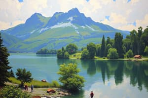
Landforms
- Gorge: A deep valley with steep and rocky side walls.
- Glacier: A mass of snow and ice that moves slowly away from its place of accumulation, carving a broad and steep-sided valley.
- Gneiss: A coarse-grained metamorphic rock with a banded structure, formed by the large-scale application of heat and pressure associated with mountain building and volcanic activity.
- Island: A mass of land that is surrounded by water and is smaller than a continent.
- Lake: A body of water that lives in a hollow in the earth’s surface and is entirely surrounded by land.
- Meander: A pronounced curve or loop in the course of a river channel.
- Peninsula: A piece of land jutting out into the sea.
- Plain: An extensive area of flat or gently undulating land.
- Plateau: An extensive elevated area of relatively flat land.
Water Features
- Estuary: The tidal mouth of a river where fresh and saline water get mixed.
- Playa: The low flat central area of a basin of inland drainage, occurring in areas of low rainfall.
- Rapids: A stretch of swift-flowing water where a river bed suddenly becomes steeper due to the presence of hard rocks.
- Tributaries: Smaller rivers or streams that flow into a main river.
Protected Areas
-
National Park: An area strictly reserved for the protection of wildlife and where activities such as forestry, grazing, or cultivation are not allowed.
-
Protected Forest: An area notified under the provisions of Indian Forest Act or the State Forest Acts, having limited degree of protection. In Protected Forests, all activities are permitted unless prohibited.
-
Reserved Forest: An area notified under the provisions of Indian Forest Act or the State Forest Acts, having full degree of protection. In Reserved Forests, all activities are prohibited unless permitted.
-
Sanctuary: An area reserved for the conservation of animals only, and operations such as harvesting of timber, collection of minor forest products are allowed so long as they do not affect the animals adversely.
-
Unclassed Forest: An area recorded as forest but not included in reserved or protected forest category, with varying ownership status from state to state.### Coastal Features
-
A coastal plain is a flat, low-lying land between the coast and higher ground inland.
-
An estuary is the tidal mouth of a river where fresh and saline water get mixed.
-
A peninsula is a piece of land jutting out into the sea.
-
An island is a mass of land that is surrounded by water and is smaller than a continent.
Landforms
- A fold is a bend in rock strata resulting from compression of an area of the earth's crust.
- A gorge is a deep valley with steep and rocky side walls.
- A lake is a body of water that lives in a hollow in the earth's surface and is entirely surrounded by land.
- A plateau is an extensive elevated area of relatively flat land.
- A plain is an extensive area of flat or gently undulating land.
- A playa is the low flat central area of a basin of inland drainage.
Geology
- Coral is a small calcium secreting marine polyp that occurs in colonies, mainly in warm shallow sea water.
- Gneiss is a coarse-grained metamorphic rock with a banded structure, formed by the large scale application of heat and pressure associated with mountain building and volcanic activity.
Weather and Climate
- A depression is an area of relatively low atmospheric pressure, found mainly in temperate regions.
- A jet stream is a very strong and steady westerly wind blowing just below the tropopause.
- A monsoon is a complete reversal of winds over a large area, leading to a change of seasons.
Environmental Conservation
- Conservation is the protection of natural environment and natural resources for the future.
- A national park is an area strictly reserved for the protection of wildlife, where activities such as forestry, grazing, or cultivation are not allowed.
- A protected forest is an area notified under the provisions of Indian Forest Act or the State Forest Acts, having limited degree of protection.
- A reserved forest is an area notified under the provisions of Indian Forest Act or the State Forest Acts, having full degree of protection.
- A sanctuary is an area reserved for the conservation of animals only, where operations such as harvesting of timber, collection of minor forest products are allowed so long as they do not affect the animals adversely.
Other
- Fauna refers to the animal life of a given area or time.
- Glaciers are masses of snow and ice that move slowly away from their place of accumulation, carving gradually a broad and steep-sided valley on their way.
- Gully erosion is the erosion of soil and rock by the concentration of runoff into gullies.
- Humus is the dead organic content of the soil.
- Landslide is a form of mass movement in which rock and debris moves rapidly downslope under the influence of gravity as a result of failure along a shear plane.
- Meander is a pronounced curve or loop in the course of a river channel.
- Rapids is a stretch of swift flowing water where a river bed suddenly becomes steeper due to the presence of hard rocks.
- Soil profile is the vertical section of soil from the ground surface to the parent rock.
- Subcontinent is a big geographical unit that stands out distinctly from the rest of the continent.
- Terai is a belt of marshy ground and vegetation on the lower parts of the alluvial fans.
- Tectonic forces are forces originating within the earth and responsible for bringing widespread changes in the landform features.
- Unclassed forest is an area recorded as forest but not included in reserved or protected forest category, with ownership status varying from state to state.
Studying That Suits You
Use AI to generate personalized quizzes and flashcards to suit your learning preferences.