Podcast
Questions and Answers
भौतिक भूगोल का ध्यान ______ भूमि-रूपों, जलवायु, और पारिस्थितिकियों पर होता है
भौतिक भूगोल का ध्यान ______ भूमि-रूपों, जलवायु, और पारिस्थितिकियों पर होता है
पृष्ठ
भौतिक भूगोल का उद्देश्य भूगोल के भौतिक विशेषताओं के ______ और अन्तर्क्रिया को समझना है
भौतिक भूगोल का उद्देश्य भूगोल के भौतिक विशेषताओं के ______ और अन्तर्क्रिया को समझना है
वितरण
भौतिक भूगोल का क्षेत्र अवलोकन, प्रयोग, मॉडलिंग, और व्याख्या को ______ करने के लिए मिलाता है
भौतिक भूगोल का क्षेत्र अवलोकन, प्रयोग, मॉडलिंग, और व्याख्या को ______ करने के लिए मिलाता है
विकसित
भौतिक भूगोल के महत्वपूर्ण पहलुओं में से एक है - ______ विकास और मापन
भौतिक भूगोल के महत्वपूर्ण पहलुओं में से एक है - ______ विकास और मापन
सैटेलाइट छवियों, जीआईएस (भौगोलिक सूचना प्रणाली), जीपीएस (ग्लोबल पोजीशनिंग सिस्टम), और दूरस्थ संवेदना ने ______ अर्जन, प्रसंस्करण, और विश्लेषण को क्रांति कर दी है
सैटेलाइट छवियों, जीआईएस (भौगोलिक सूचना प्रणाली), जीपीएस (ग्लोबल पोजीशनिंग सिस्टम), और दूरस्थ संवेदना ने ______ अर्जन, प्रसंस्करण, और विश्लेषण को क्रांति कर दी है
भूतकृत नली और कैचमेंट को ध्यान में रखते हुए पानी के संसाधन ______ का संबोधन करने के लिए विशेषज्ञता है
भूतकृत नली और कैचमेंट को ध्यान में रखते हुए पानी के संसाधन ______ का संबोधन करने के लिए विशेषज्ञता है
Flashcards are hidden until you start studying
Study Notes
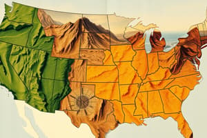
Physical Geography Overview
Physical geography is a branch of geography focused on studying the Earth's landforms, climates, and ecosystems. It aims to understand the distribution and interaction of physical features, their dynamics, and the driving forces behind them. The field combines observation, experimentation, modeling, and interpretation to develop theories about landscape evolution and patterns.
Key aspects of physical geography include:
- Landform development and morphometry: Studying the origin and shape of earth surfaces through erosion, weathering, deposition, and transportation processes.
- Soils and geomorphology: Examining soil formation, distribution, and properties to understand landscapes.
- Climatology: Investigating atmospheric phenomena, temperature, precipitation, and wind patterns to comprehend weather systems and global climate trends.
- Ecological geography: Analyzing interactions among living organisms, abiotic components, and landscapes.
- Water resources management: Addressing water availability, conservation, and efficient usage considering hydrological cycles and catchments.
In the past decade, technological advances have greatly impacted physical geography. Satellite imagery, GIS (Geographic Information Systems), GPS (Global Positioning System), and remote sensing have revolutionized data acquisition, processing, and analysis. These tools allow for precision measurement, modeling of dynamic processes, and improved understanding of surface changes over time.
Studying That Suits You
Use AI to generate personalized quizzes and flashcards to suit your learning preferences.