Podcast
Questions and Answers
What are the major physical features of India mentioned in the content?
What are the major physical features of India mentioned in the content?
The major physical features include the Himalayan Mountains, Northern Plains, Peninsular Plateau, Indian Desert, Coastal Plains, and Islands.
Describe the geological significance of the Peninsular Plateau.
Describe the geological significance of the Peninsular Plateau.
The Peninsular Plateau is one of the ancient landmasses and is considered one of the most stable land blocks on the earth's surface.
How do the Himalayan Mountains differ from the Northern Plains?
How do the Himalayan Mountains differ from the Northern Plains?
The Himalayas are geologically young, characterized by high peaks and rugged terrain, while the Northern Plains are formed from alluvial deposits and are flatter.
What is the orientation of the Himalayan Mountain system?
What is the orientation of the Himalayan Mountain system?
What are the characteristics of the Himalayan mountain ranges?
What are the characteristics of the Himalayan mountain ranges?
Why are the altitudinal variations greater in the eastern half of the Himalayas?
Why are the altitudinal variations greater in the eastern half of the Himalayas?
What type of rocks primarily make up the Peninsular Plateau?
What type of rocks primarily make up the Peninsular Plateau?
What geographical feature merges with the western extension of the region described?
What geographical feature merges with the western extension of the region described?
In what direction does the flow of rivers like Chambal and Betwa drain in this region?
In what direction does the flow of rivers like Chambal and Betwa drain in this region?
What is the average elevation range of the Western Ghats?
What is the average elevation range of the Western Ghats?
What local names refer to the eastward extensions of the Central Highlands?
What local names refer to the eastward extensions of the Central Highlands?
What causes orographic rain along the Western Ghats?
What causes orographic rain along the Western Ghats?
Name the highest peak in the Western Ghats.
Name the highest peak in the Western Ghats.
What is the approximate average elevation of the Eastern Ghats?
What is the approximate average elevation of the Eastern Ghats?
Where do the Eastern Ghats stretch from?
Where do the Eastern Ghats stretch from?
What is the highest peak in the Eastern Ghats?
What is the highest peak in the Eastern Ghats?
How do the Eastern Ghats differ from the Western Ghats in terms of continuity?
How do the Eastern Ghats differ from the Western Ghats in terms of continuity?
What is the administrative headquarters of the Lakshadweep Islands?
What is the administrative headquarters of the Lakshadweep Islands?
In which oceanic region is India's only active volcano located?
In which oceanic region is India's only active volcano located?
What are the primary conditions in which coral polyps thrive?
What are the primary conditions in which coral polyps thrive?
What were the former names of Lakshadweep Islands before 1973?
What were the former names of Lakshadweep Islands before 1973?
What is the significance of the northern plains in India?
What is the significance of the northern plains in India?
What are the names of Mussoorie, Nainital, and Ranikhet's respective states?
What are the names of Mussoorie, Nainital, and Ranikhet's respective states?
Name two glaciers located in the Great Himalayas.
Name two glaciers located in the Great Himalayas.
What are the Shiwaliks in the context of the Himalayas?
What are the Shiwaliks in the context of the Himalayas?
Identify the states where the highest peaks of the Himalayas are located.
Identify the states where the highest peaks of the Himalayas are located.
What are the Duns in relation to the Himalayan ranges?
What are the Duns in relation to the Himalayan ranges?
What type of rock primarily composes the Purvachal or Eastern hills?
What type of rock primarily composes the Purvachal or Eastern hills?
What marks the eastern-most boundary of the Himalayas?
What marks the eastern-most boundary of the Himalayas?
List the names of two mountain ranges included in the Purvachal.
List the names of two mountain ranges included in the Purvachal.
How are the Himalayas divided based on regions?
How are the Himalayas divided based on regions?
What are the distributaries in the context of the bhangar region?
What are the distributaries in the context of the bhangar region?
What is the primary characteristic of khadar soil?
What is the primary characteristic of khadar soil?
What types of rocks make up the Peninsular plateau?
What types of rocks make up the Peninsular plateau?
How was the Peninsular plateau formed?
How was the Peninsular plateau formed?
What are the main divisions of the Peninsular plateau?
What are the main divisions of the Peninsular plateau?
Where is the Chotanagpur plateau located?
Where is the Chotanagpur plateau located?
What distinguishes the elevation of the Deccan Plateau?
What distinguishes the elevation of the Deccan Plateau?
What are the prominent hill ranges of the northeastern extension of the Peninsular plateau?
What are the prominent hill ranges of the northeastern extension of the Peninsular plateau?
What geographical feature bounds the Vindhyan range?
What geographical feature bounds the Vindhyan range?
What are the Western and Eastern Ghats, and how do they relate to the Deccan Plateau?
What are the Western and Eastern Ghats, and how do they relate to the Deccan Plateau?
Flashcards
What are the Himalayas?
What are the Himalayas?
The Himalayan Mountains stretch across the northern border of India, forming a massive arc of towering peaks and deep valleys.
Are the Himalayas stable?
Are the Himalayas stable?
The Himalayas, geologically young, are still growing and shifting.
What is the significance of the Himalayas?
What is the significance of the Himalayas?
They form a natural barrier between India and other countries, influencing climate and culture.
How were the Northern Plains formed?
How were the Northern Plains formed?
Signup and view all the flashcards
Why are the Northern Plains important?
Why are the Northern Plains important?
Signup and view all the flashcards
What is the Peninsular Plateau?
What is the Peninsular Plateau?
Signup and view all the flashcards
What are the characteristics of the Peninsular Plateau?
What are the characteristics of the Peninsular Plateau?
Signup and view all the flashcards
Shiwaliks
Shiwaliks
Signup and view all the flashcards
Duns
Duns
Signup and view all the flashcards
Eastern Boundary of the Himalayas
Eastern Boundary of the Himalayas
Signup and view all the flashcards
Purvachal
Purvachal
Signup and view all the flashcards
Purvachal Structure
Purvachal Structure
Signup and view all the flashcards
Regional Names of the Himalayas
Regional Names of the Himalayas
Signup and view all the flashcards
Himalayan Divisions
Himalayan Divisions
Signup and view all the flashcards
States with Highest Peaks
States with Highest Peaks
Signup and view all the flashcards
Glaciers and Passes in the Himalayas
Glaciers and Passes in the Himalayas
Signup and view all the flashcards
Andaman & Nicobar Islands
Andaman & Nicobar Islands
Signup and view all the flashcards
Lakshadweep Islands
Lakshadweep Islands
Signup and view all the flashcards
Coral Polyps
Coral Polyps
Signup and view all the flashcards
Coral Reefs
Coral Reefs
Signup and view all the flashcards
Fringing Reef
Fringing Reef
Signup and view all the flashcards
What is a plateau?
What is a plateau?
Signup and view all the flashcards
How is the Peninsular Plateau divided?
How is the Peninsular Plateau divided?
Signup and view all the flashcards
What mountain ranges are located in the Central Highlands?
What mountain ranges are located in the Central Highlands?
Signup and view all the flashcards
What is the Deccan Plateau?
What is the Deccan Plateau?
Signup and view all the flashcards
What mountain ranges flank the Deccan Plateau?
What mountain ranges flank the Deccan Plateau?
Signup and view all the flashcards
Where is the Chotanagpur Plateau located?
Where is the Chotanagpur Plateau located?
Signup and view all the flashcards
What is the Malwa Plateau?
What is the Malwa Plateau?
Signup and view all the flashcards
What is Khadar?
What is Khadar?
Signup and view all the flashcards
What is Bhangar?
What is Bhangar?
Signup and view all the flashcards
What are the Western Ghats?
What are the Western Ghats?
Signup and view all the flashcards
What are the Eastern Ghats?
What are the Eastern Ghats?
Signup and view all the flashcards
Which mountain range is higher, Eastern Ghats or Western Ghats?
Which mountain range is higher, Eastern Ghats or Western Ghats?
Signup and view all the flashcards
Where are the Eastern Ghats located?
Where are the Eastern Ghats located?
Signup and view all the flashcards
How do the Western Ghats impact rainfall?
How do the Western Ghats impact rainfall?
Signup and view all the flashcards
Are the Western Ghats known by different names?
Are the Western Ghats known by different names?
Signup and view all the flashcards
What is the trend in the height of the Western Ghats?
What is the trend in the height of the Western Ghats?
Signup and view all the flashcards
What are the highest peaks in the Western Ghats?
What are the highest peaks in the Western Ghats?
Signup and view all the flashcards
What is the highest peak in the Eastern Ghats?
What is the highest peak in the Eastern Ghats?
Signup and view all the flashcards
What are the Eastern extensions of the Central Highlands known as?
What are the Eastern extensions of the Central Highlands known as?
Signup and view all the flashcards
Study Notes
Physical Features of India
- India has a diverse range of landforms, including mountains, plains, deserts, plateaus, and islands.
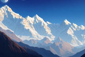
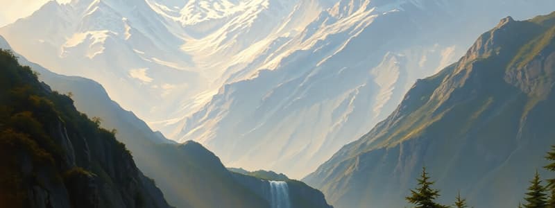
- The Himalayas are young, folded mountains stretching along the northern border. They run west to east, from the Indus to the Brahmaputra.
- The Himalayas are one of the most rugged mountain ranges in the world, with peaks over 8,000 meters high.
- The Himalayas are divided into three parallel ranges: the Himadri (highest), the Himachal, and the Shiwaliks.
- The Northern Plains are formed by the interplay of the Indus, Ganga, and Brahmaputra rivers and their tributaries, creating fertile alluvial soil.
- The Peninsular Plateau is one of the oldest landmasses on Earth, formed by the break-up of the Gondwana landmass.
- The Deccan Plateau is part of the Peninsular Plateau, with a triangular shape and high elevation in the west, sloping gently to the east.
- The Indian Desert is characterized by arid conditions, with very low rainfall and sand dunes.
- The Coastal Plains stretch along the Arabian Sea and the Bay of Bengal, with various regions like the Konkan, Kannad, and Malabar Coast. The Eastern Coastal Plains are wider than the Western Coastal Plains.
- The islands of India include the Andaman and Nicobar Islands in the Bay of Bengal, and the Lakshadweep Islands off the Malabar Coast. These are primarily coral islands.
Major Physiographic Divisions
- Himalayan Mountains
- Northern Plains
- Peninsular Plateau
- Indian Desert
- Coastal Plains
- Islands
Important Features
- The Great Himalayas or Himadri form the highest range.
- The Pir Panjal range is the longest and most important range in the Lesser Himalayas (Himachal).
- The Shiwaliks are the outermost range.
- The Ganga Plain covers a vast area, encompassing Haryana, Delhi, Uttar Pradesh, Bihar and parts of Jharkhand and West Bengal.
- The Deccan Plateau is known for its extensive plateaus that extend to the east and west coasts.
- The Western Ghats are higher and more continuous than the Eastern Ghats, with significant diversity in elevations.
- The Indian Desert is located in the western part of the country.
Studying That Suits You
Use AI to generate personalized quizzes and flashcards to suit your learning preferences.