Podcast
Questions and Answers
Which mountain range is the highest in the world?
Which mountain range is the highest in the world?
- The Rockies
- The Himalayas (correct)
- The Andes
- The Alps
Which of the following rivers is NOT a major contributor to the formation of the northern plains?
Which of the following rivers is NOT a major contributor to the formation of the northern plains?
- Narmada (correct)
- Ganga
- Satluj
- Brahmaputra
Which of the following is another name for the Greater Himalaya range?
Which of the following is another name for the Greater Himalaya range?
- Himadri (correct)
- Shiwalik
- Himachal
- Purvachal
Which hill range is NOT part of the Purvachal Hill Ranges?
Which hill range is NOT part of the Purvachal Hill Ranges?
What is the name given to the hills located to the south of the Middle Himalaya?
What is the name given to the hills located to the south of the Middle Himalaya?
Which desert lies to the west of the Aravalli Range in Rajasthan?
Which desert lies to the west of the Aravalli Range in Rajasthan?
What is the general shape of the Southern Plateaus?
What is the general shape of the Southern Plateaus?
Which of the following plains is located between the Eastern Ghats and the Bay of Bengal?
Which of the following plains is located between the Eastern Ghats and the Bay of Bengal?
Which river roughly divides the plateau region into two parts?
Which river roughly divides the plateau region into two parts?
What is the name of the highest peak in the Deccan Plateau region?
What is the name of the highest peak in the Deccan Plateau region?
Which of these states is part of the Ganga Plain?
Which of these states is part of the Ganga Plain?
What is the other name of Outer Himalaya?
What is the other name of Outer Himalaya?
Which sea borders the Western Coastal Plain?
Which sea borders the Western Coastal Plain?
Which of the following landforms are NOT found in India?
Which of the following landforms are NOT found in India?
Which of these peaks resides in the Greater Himalaya range?
Which of these peaks resides in the Greater Himalaya range?
How do the Northern Plains primarily contribute to India's economic activities?
How do the Northern Plains primarily contribute to India's economic activities?
Which of the following best describes the geological significance of the Himalayan mountain range?
Which of the following best describes the geological significance of the Himalayan mountain range?
How does the location of the Western Desert impact the climate of the surrounding regions?
How does the location of the Western Desert impact the climate of the surrounding regions?
What is a distinguishing characteristic of the Eastern Coastal Plain compared to the Western Coastal Plain in India?
What is a distinguishing characteristic of the Eastern Coastal Plain compared to the Western Coastal Plain in India?
Which of the following is a significant environmental challenge associated with the Northern Plains?
Which of the following is a significant environmental challenge associated with the Northern Plains?
How do the Himalayan mountain ranges influence the climate and weather patterns of India?
How do the Himalayan mountain ranges influence the climate and weather patterns of India?
What geological process is primarily responsible for the formation of the island of Lakshadweep?
What geological process is primarily responsible for the formation of the island of Lakshadweep?
How does the presence of the Western Ghats influence rainfall patterns in the region?
How does the presence of the Western Ghats influence rainfall patterns in the region?
What impact does the Deccan Plateau have on the river systems of peninsular India?
What impact does the Deccan Plateau have on the river systems of peninsular India?
What distinct characteristic defines the Purvachal Hill Ranges compared to the other Himalayan ranges?
What distinct characteristic defines the Purvachal Hill Ranges compared to the other Himalayan ranges?
How is the Thar Desert's ecosystem uniquely adapted to its arid conditions?
How is the Thar Desert's ecosystem uniquely adapted to its arid conditions?
What role do the coastal plains play in India's trade and transportation network?
What role do the coastal plains play in India's trade and transportation network?
Which factor most significantly contributes to the agricultural productivity of the Northern Plains?
Which factor most significantly contributes to the agricultural productivity of the Northern Plains?
How do the geographical features of the Southern Plateaus influence the region's economic activities?
How do the geographical features of the Southern Plateaus influence the region's economic activities?
What is the most significant environmental impact of deforestation in the Himalayan region?
What is the most significant environmental impact of deforestation in the Himalayan region?
The Himalayas stretch from Jammu & Kashmir to Arunachal Pradesh.
The Himalayas stretch from Jammu & Kashmir to Arunachal Pradesh.
Mount Everest is located entirely within India.
Mount Everest is located entirely within India.
The Himadri range is another name for the Middle Himalaya.
The Himadri range is another name for the Middle Himalaya.
Shimla is a hill station located in the Middle Himalaya.
Shimla is a hill station located in the Middle Himalaya.
The Shiwalik range is the highest of the three Himalayan ranges.
The Shiwalik range is the highest of the three Himalayan ranges.
The Purvanchal hills are located in the northwest of India.
The Purvanchal hills are located in the northwest of India.
The Northern Plains are formed by the deposition of silt from the Satluj, Ganga, and Yamuna rivers.
The Northern Plains are formed by the deposition of silt from the Satluj, Ganga, and Yamuna rivers.
The Punjab-Haryana Plains are formed by the Sutlej, and Beas rivers.
The Punjab-Haryana Plains are formed by the Sutlej, and Beas rivers.
The Ganga Plain includes the states of Uttarakhand, Uttar Pradesh, Bihar, and West Bengal.
The Ganga Plain includes the states of Uttarakhand, Uttar Pradesh, Bihar, and West Bengal.
The Brahmaputra Plain is primarily located in Kerala.
The Brahmaputra Plain is primarily located in Kerala.
The coastal plains stretch from Gujarat to West Bengal.
The coastal plains stretch from Gujarat to West Bengal.
The Western Coastal Plain is wider than the Eastern Coastal Plain.
The Western Coastal Plain is wider than the Eastern Coastal Plain.
The Thar Desert is located to the east of the Aravalli Range.
The Thar Desert is located to the east of the Aravalli Range.
The Southern Plateaus cover the state of Gujarat.
The Southern Plateaus cover the state of Gujarat.
The Andaman and Nicobar Islands are located in the Arabian Sea.
The Andaman and Nicobar Islands are located in the Arabian Sea.
The Himalayas stretch from Jammu & Kashmir to Arunachal Pradesh, passing through Kerala.
The Himalayas stretch from Jammu & Kashmir to Arunachal Pradesh, passing through Kerala.
Mount Everest, the highest peak in the world, is located entirely within the borders of India.
Mount Everest, the highest peak in the world, is located entirely within the borders of India.
The Greater Himalaya, also known as Himadri, is the lowest in height compared to the other Himalayan ranges.
The Greater Himalaya, also known as Himadri, is the lowest in height compared to the other Himalayan ranges.
Shimla and Nainital, popular hill stations, are situated in the Outer Himalaya range.
Shimla and Nainital, popular hill stations, are situated in the Outer Himalaya range.
The Shiwalik range, also known as the Outer Himalaya, is the highest in elevation compared to the other Himalayan ranges.
The Shiwalik range, also known as the Outer Himalaya, is the highest in elevation compared to the other Himalayan ranges.
The Purvachal Hill Ranges cover the north-eastern states, including Assam and West Bengal.
The Purvachal Hill Ranges cover the north-eastern states, including Assam and West Bengal.
The fertile Northern Plains are primarily formed by the deposition of silt from the Godavari, Krishna and Kaveri rivers.
The fertile Northern Plains are primarily formed by the deposition of silt from the Godavari, Krishna and Kaveri rivers.
The Punjab-Haryana Plains were formed by the combined efforts of River Ganga and its tributaries.
The Punjab-Haryana Plains were formed by the combined efforts of River Ganga and its tributaries.
The Eastern Coastal Plain is narrower than the Western Coastal Plain.
The Eastern Coastal Plain is narrower than the Western Coastal Plain.
The Coromandel Coast is a part of the Western Coastal Plain.
The Coromandel Coast is a part of the Western Coastal Plain.
The Thar Desert stretches from the Rann of Kachchh in Gujarat through Rajasthan to the borders of Punjab.
The Thar Desert stretches from the Rann of Kachchh in Gujarat through Rajasthan to the borders of Punjab.
The Southern Plateaus are primarily composed of alluvial soil, making them exceptionally fertile for agriculture.
The Southern Plateaus are primarily composed of alluvial soil, making them exceptionally fertile for agriculture.
The Deccan Plateau is located to the north of the Central Highlands.
The Deccan Plateau is located to the north of the Central Highlands.
The Eastern and Western Ghats converge at the Aravalli Hills.
The Eastern and Western Ghats converge at the Aravalli Hills.
Lakshadweep Islands, located in the Bay of Bengal, are characterized by their hilly terrain.
Lakshadweep Islands, located in the Bay of Bengal, are characterized by their hilly terrain.
The Himalayas stretch from Jammu & Kashmir to Arunachal Pradesh through Ladakh, Himachal Pradesh, Uttarakhand, Sikkim, and ______ in West Bengal.
The Himalayas stretch from Jammu & Kashmir to Arunachal Pradesh through Ladakh, Himachal Pradesh, Uttarakhand, Sikkim, and ______ in West Bengal.
______ is the highest peak in the world, located in the Himalayas on the border between Nepal and China.
______ is the highest peak in the world, located in the Himalayas on the border between Nepal and China.
The Greater Himalaya is also called ______.
The Greater Himalaya is also called ______.
______ are found in the Greater Himalaya due to the perennial snow cover.
______ are found in the Greater Himalaya due to the perennial snow cover.
The Middle Himalaya is also called ______.
The Middle Himalaya is also called ______.
______, Nainital, and Darjeeling are hill stations situated in the Middle Himalaya.
______, Nainital, and Darjeeling are hill stations situated in the Middle Himalaya.
The Purvachal Hill Ranges are also known as the ______.
The Purvachal Hill Ranges are also known as the ______.
The Northern Plains lie towards the south of the ______.
The Northern Plains lie towards the south of the ______.
The Punjab-Haryana Plains are formed by River Satluj and its tributary, ______.
The Punjab-Haryana Plains are formed by River Satluj and its tributary, ______.
River ______ and its tributaries have formed the Ganga Plain.
River ______ and its tributaries have formed the Ganga Plain.
The coastal plain is divided into Western Coastal Plain and ______ Coastal Plain.
The coastal plain is divided into Western Coastal Plain and ______ Coastal Plain.
The Western Coastal Plain lies between the Western Ghats and the ______ Sea.
The Western Coastal Plain lies between the Western Ghats and the ______ Sea.
The ______ Desert is also called the Great Indian Desert or the Thar Desert.
The ______ Desert is also called the Great Indian Desert or the Thar Desert.
The southern plateaus are ______ in shape and are surrounded by hill ranges.
The southern plateaus are ______ in shape and are surrounded by hill ranges.
The __________ are the highest mountain chain in the world, stretching from Jammu & Kashmir to Arunachal Pradesh.
The __________ are the highest mountain chain in the world, stretching from Jammu & Kashmir to Arunachal Pradesh.
Most peaks in the Himalayas remain __________ throughout the year, influencing the region's climate and water resources.
Most peaks in the Himalayas remain __________ throughout the year, influencing the region's climate and water resources.
__________ which is located in the Himalayas, is the highest peak in the world, situated on the border between Nepal and China.
__________ which is located in the Himalayas, is the highest peak in the world, situated on the border between Nepal and China.
The Greater Himalaya, also known as __________, is the northernmost and highest of the three parallel ranges, characterized by glaciers and snow cover.
The Greater Himalaya, also known as __________, is the northernmost and highest of the three parallel ranges, characterized by glaciers and snow cover.
Hill stations such as Shimla, Nainital, and Darjeeling are located in the __________ lies to the south of the Greater Himalaya.
Hill stations such as Shimla, Nainital, and Darjeeling are located in the __________ lies to the south of the Greater Himalaya.
The __________ also known as Shiwalik, is the southernmost and lowest in height and is located to the south of the Middle Himalaya.
The __________ also known as Shiwalik, is the southernmost and lowest in height and is located to the south of the Middle Himalaya.
The Purvachal Hill Ranges, also known as the __________, cover the north-eastern states of India, featuring hills like Garo, Khasi, and Naga.
The Purvachal Hill Ranges, also known as the __________, cover the north-eastern states of India, featuring hills like Garo, Khasi, and Naga.
The Northern Plains are formed due to the deposition of __________ by the Satluj, Ganga, and Brahmaputra rivers, making them fertile and ideal for cultivation.
The Northern Plains are formed due to the deposition of __________ by the Satluj, Ganga, and Brahmaputra rivers, making them fertile and ideal for cultivation.
The __________ and its tributary, Beas, have formed the Punjab-Haryana Plains, covering the states of Punjab and Haryana.
The __________ and its tributary, Beas, have formed the Punjab-Haryana Plains, covering the states of Punjab and Haryana.
The Ganga Plain, formed by the River Ganga and its tributaries, includes the states of Uttarakhand, Uttar Pradesh, Bihar, and __________.
The Ganga Plain, formed by the River Ganga and its tributaries, includes the states of Uttarakhand, Uttar Pradesh, Bihar, and __________.
The Brahmaputra Plain, situated in Assam, is formed by the __________ and its tributaries.
The Brahmaputra Plain, situated in Assam, is formed by the __________ and its tributaries.
The Coastal Plains of India are divided into the Western Coastal Plain and __________ stretching from Gujarat to West Bengal and meeting at Kanyakumari.
The Coastal Plains of India are divided into the Western Coastal Plain and __________ stretching from Gujarat to West Bengal and meeting at Kanyakumari.
The Western Coastal Plain lies between the Western Ghats and the __________ and is divided into the Gujarat Coast, Konkan Coast, and Malabar Coast.
The Western Coastal Plain lies between the Western Ghats and the __________ and is divided into the Gujarat Coast, Konkan Coast, and Malabar Coast.
The __________ located to the west of the Aravalli Range in Rajasthan, stretches from the Rann of Kachchh to the borders of Haryana.
The __________ located to the west of the Aravalli Range in Rajasthan, stretches from the Rann of Kachchh to the borders of Haryana.
The Southern Plateaus, triangular in shape and surrounded by hill ranges, cover the states of Madhya Pradesh, Chhattisgarh, and ___________ among others.
The Southern Plateaus, triangular in shape and surrounded by hill ranges, cover the states of Madhya Pradesh, Chhattisgarh, and ___________ among others.
What is the name of the highest mountain chain in the world?
What is the name of the highest mountain chain in the world?
Name the three major rivers that deposit silt to form the northern plains of India.
Name the three major rivers that deposit silt to form the northern plains of India.
What is the alternative name for the Greater Himalaya?
What is the alternative name for the Greater Himalaya?
What is the name given to the hills in the north-eastern states of India?
What is the name given to the hills in the north-eastern states of India?
What is another name for the Outer Himalaya?
What is another name for the Outer Himalaya?
Between which landforms does the Western Coastal Plain lie?
Between which landforms does the Western Coastal Plain lie?
What is the name of India's largest desert?
What is the name of India's largest desert?
What are the small hills of sand found in the Thar Desert called?
What are the small hills of sand found in the Thar Desert called?
Name the two parts into which River Narmada divides the southern plateau region.
Name the two parts into which River Narmada divides the southern plateau region.
What is the highest peak in the Deccan Plateau region?
What is the highest peak in the Deccan Plateau region?
What is the name of the coast on the eastern coastal plain's southern part?
What is the name of the coast on the eastern coastal plain's southern part?
What is the name for a landmass surrounded by water on all sides?
What is the name for a landmass surrounded by water on all sides?
Name the hill station located in the Middle Himalayas.
Name the hill station located in the Middle Himalayas.
What are the names of the island groups of India located away from the coast?
What are the names of the island groups of India located away from the coast?
What is the name of the highest peak in Himalayas?
What is the name of the highest peak in Himalayas?
Explain how the formation of the Northern Plains is directly linked to the presence of the Himalayas.
Explain how the formation of the Northern Plains is directly linked to the presence of the Himalayas.
Describe the general east-to-west elevation pattern observed in the Himalayas, and name the three major parallel ranges.
Describe the general east-to-west elevation pattern observed in the Himalayas, and name the three major parallel ranges.
Compare and contrast the Western and Eastern Coastal Plains of India with respect to their width and the water bodies they border.
Compare and contrast the Western and Eastern Coastal Plains of India with respect to their width and the water bodies they border.
What is the significance of the Purvanchal ranges in the context of India's physical divisions, and where are these ranges located?
What is the significance of the Purvanchal ranges in the context of India's physical divisions, and where are these ranges located?
How does the River Narmada act as a dividing line for the Southern Plateaus, and what are the two main divisions created by it?
How does the River Narmada act as a dividing line for the Southern Plateaus, and what are the two main divisions created by it?
Explain why the Northern Plains are agriculturally significant to India.
Explain why the Northern Plains are agriculturally significant to India.
Briefly describe the location and main characteristics of the Thar Desert.
Briefly describe the location and main characteristics of the Thar Desert.
Name the hill ranges that surround the Central Highlands, specifying their directions relative to the highlands.
Name the hill ranges that surround the Central Highlands, specifying their directions relative to the highlands.
What are the key differences between the islands of Lakshadweep and the Andaman and Nicobar Islands in terms of their physical characteristics?
What are the key differences between the islands of Lakshadweep and the Andaman and Nicobar Islands in terms of their physical characteristics?
Identify the states that are part of the Ganga Plain.
Identify the states that are part of the Ganga Plain.
Flashcards
The Himalayas
The Himalayas
The highest mountain chain in the world, stretching from Jammu & Kashmir to Arunachal Pradesh.
The Greater Himalaya
The Greater Himalaya
The northernmost range of the Himalayas, also known as Himadri, with high peaks and glaciers.
The Middle Himalaya
The Middle Himalaya
Located south of the Greater Himalaya, containing hill stations like Shimla and Darjeeling.
The Outer Himalaya
The Outer Himalaya
Signup and view all the flashcards
Purvachal Hill Ranges
Purvachal Hill Ranges
Signup and view all the flashcards
The Northern Plains
The Northern Plains
Signup and view all the flashcards
The Coastal Plains
The Coastal Plains
Signup and view all the flashcards
Western Coastal Plain
Western Coastal Plain
Signup and view all the flashcards
Eastern Coastal Plain
Eastern Coastal Plain
Signup and view all the flashcards
The Western Desert
The Western Desert
Signup and view all the flashcards
The Southern Plateaus
The Southern Plateaus
Signup and view all the flashcards
The Central Highlands
The Central Highlands
Signup and view all the flashcards
The Deccan Plateau
The Deccan Plateau
Signup and view all the flashcards
Island
Island
Signup and view all the flashcards
Andaman and Nicobar Islands & Lakshadweep
Andaman and Nicobar Islands & Lakshadweep
Signup and view all the flashcards
Mount Everest
Mount Everest
Signup and view all the flashcards
Kanchenjunga
Kanchenjunga
Signup and view all the flashcards
Punjab-Haryana Plains
Punjab-Haryana Plains
Signup and view all the flashcards
Ganga Plain
Ganga Plain
Signup and view all the flashcards
Brahmaputra Plain
Brahmaputra Plain
Signup and view all the flashcards
Northern Circars
Northern Circars
Signup and view all the flashcards
Coromandel Coast
Coromandel Coast
Signup and view all the flashcards
Sand dunes
Sand dunes
Signup and view all the flashcards
Aravalli Range
Aravalli Range
Signup and view all the flashcards
Vindhya Range
Vindhya Range
Signup and view all the flashcards
Chota Nagpur Plateau
Chota Nagpur Plateau
Signup and view all the flashcards
Ramgarh Hills
Ramgarh Hills
Signup and view all the flashcards
Malwa Plateau
Malwa Plateau
Signup and view all the flashcards
Anai Mudi
Anai Mudi
Signup and view all the flashcards
Nilgiri Hills
Nilgiri Hills
Signup and view all the flashcards
Physical Divisions of India
Physical Divisions of India
Signup and view all the flashcards
Divisions of Western Coastal Plain
Divisions of Western Coastal Plain
Signup and view all the flashcards
What are Sand Dunes?
What are Sand Dunes?
Signup and view all the flashcards
River Narmada's Division
River Narmada's Division
Signup and view all the flashcards
Andaman and Nicobar Islands
Andaman and Nicobar Islands
Signup and view all the flashcards
Lakshadweep Islands
Lakshadweep Islands
Signup and view all the flashcards
What are the Purvachal Ranges?
What are the Purvachal Ranges?
Signup and view all the flashcards
What creates the Northern Plains?
What creates the Northern Plains?
Signup and view all the flashcards
States Included in the Coastal Plains
States Included in the Coastal Plains
Signup and view all the flashcards
What is a Coastal Plain?
What is a Coastal Plain?
Signup and view all the flashcards
Geographical span of the Western Desert?
Geographical span of the Western Desert?
Signup and view all the flashcards
Location of the southern plateau
Location of the southern plateau
Signup and view all the flashcards
What are the Central Highlands?
What are the Central Highlands?
Signup and view all the flashcards
What is Dadra and Nagar Haveli and Daman and Diu?
What is Dadra and Nagar Haveli and Daman and Diu?
Signup and view all the flashcards
How many ranges make up the Himalayas?
How many ranges make up the Himalayas?
Signup and view all the flashcards
Locations of Hill Stations
Locations of Hill Stations
Signup and view all the flashcards
What is a Plain?
What is a Plain?
Signup and view all the flashcards
What is the River Brahmaputra?
What is the River Brahmaputra?
Signup and view all the flashcards
Main components of the Northern Plains
Main components of the Northern Plains
Signup and view all the flashcards
What is the Purvachal Hill Range?
What is the Purvachal Hill Range?
Signup and view all the flashcards
What is the Aravalli Range?
What is the Aravalli Range?
Signup and view all the flashcards
What are the Northern Circars
What are the Northern Circars
Signup and view all the flashcards
What is the Coromandel Coast?
What is the Coromandel Coast?
Signup and view all the flashcards
The River Satluj and its tributary Beas
The River Satluj and its tributary Beas
Signup and view all the flashcards
Component of the Ganga Plain
Component of the Ganga Plain
Signup and view all the flashcards
What are the Purvanchal hills?
What are the Purvanchal hills?
Signup and view all the flashcards
What is the Southern Plateau?
What is the Southern Plateau?
Signup and view all the flashcards
Plains between Punjab and Haryana
Plains between Punjab and Haryana
Signup and view all the flashcards
What defines an island?
What defines an island?
Signup and view all the flashcards
The Purvachal Ranges
The Purvachal Ranges
Signup and view all the flashcards
Fertile Plains
Fertile Plains
Signup and view all the flashcards
Study Notes
- India's landforms include mountains, hills, plains, plateaus, and deserts
- India is divided into five major physical divisions
The Northern Mountains
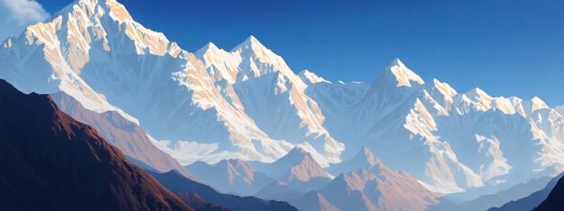
- The Himalayas are the world's highest mountain chain
- The Himalayas stretch from Jammu & Kashmir to Arunachal Pradesh
- Areas covered include Ladakh, Himachal Pradesh, Uttarakhand, Sikkim, and Darjeeling in West Bengal
- Most peaks in the Himalayas remain snow-covered year-round
- Mount Everest, the world's highest peak, is in the Himalayas, on the Nepal-China border
- The Himalayas consist of three parallel ranges.
The Greater Himalaya
- The Greater Himalaya is in the extreme north and is also called Himadri
- It is the highest of the three ranges and remains snow covered throughout the year
- Glaciers are common in these mountains
- Kanchenjunga is a very high peak in this range
- Mount Everest also lies within the Greater Himalaya range
The Middle Himalaya
- The Middle Himalaya lies to the south of the Greater Himalaya, also called Himachal
- It is lower in height than the Greater Himalaya
- Hill stations such as Shimla, Nainital, and Darjeeling are situated here
The Outer Himalaya
- The Outer Himalaya is located to the south of the Middle Himalaya, also called Shiwalik
- It is the lowest in height
The Karakoram Range
- The Karakoram Range is to the north-west of the Himalayas
- It is a hill range
- This hill range is a part of the Khasi
The Purvachal Hill Ranges
- The Purvachal Hill Ranges are in the north-east, also known as the North-Eastern Hills
- They cover the north-eastern states, including eastern Arunachal Pradesh, Nagaland, Manipur, Mizoram, Tripura, and Meghalaya
- Garo, Khasi, Jaintia, Naga, Lohas, and Mizo hills are part of the Purvachal Hill Ranges
- These hills are not very high.
The Plains
- The Plains lie to the south of the Himalayas, stretching from Punjab to Assam
- The plains are formed by silt deposition from the Satluj, Ganga, and Brahmaputra rivers and their tributaries
- These plains are fertile and good for cultivation
The Punjab-Haryana Plains
- The Punjab-Haryana Plains are formed by the Satluj River and its tributary, Beas
- These plains cover the states of Punjab and Haryana
The Ganga Plain
- The Ganga Plain is formed by the Ganga River and its tributaries
- Uttarakhand, Uttar Pradesh, Bihar, and West Bengal are part of the Ganga Plain
The Brahmaputra Plain
- The Brahmaputra Plain is formed by the Brahmaputra River and its tributaries
- It is located in Assam
The Coastal Plains
- The plain along the coast is the coastal plain, divided into Western and Eastern Coastal Plains
- They stretch from Gujarat to West Bengal
- The plains cover parts of Gujarat, Maharashtra, Goa, Karnataka, Kerala, Tamil Nadu, Andhra Pradesh, Odisha, and West Bengal
- The two coastal plains meet at Kanyakumari
Western Coastal Plain
- The Western Coastal Plain lies between the Western Ghats and the Arabian Sea, stretching from Gujarat to Kerala
- It is divided into Gujarat Coast, Konkan Coast, and Malabar Coast
- Lagoons or backwaters are found along the Malabar Coast
Eastern Coastal Plain
- The Eastern Coastal Plain lies between the Eastern Ghats and the Bay of Bengal, stretching from West Bengal to Tamil Nadu
- It is wider than the Western Coastal Plain
- The northern part is known as the Northern Circars, and the southern part is called the Coromandel Coast
The Western Desert
- The western desert lies to the west of the Aravalli Range in Rajasthan
- It is also called the Great Indian Desert or the Thar Desert
- It stretches from the Rann of Kachchh in Gujarat through Rajasthan to the borders of Haryana
- It is rocky and sandy, featuring sand dunes in some places
- Sand dunes are common in the Thar Desert
The Southern Plateaus
- The southern plateaus are located to the south of the Plains
- The plateaus cover Madhya Pradesh, Chhattisgarh, Jharkhand, Odisha, Telangana, Andhra Pradesh, Tamil Nadu, Karnataka, and Maharashtra
- They are triangular in shape and surrounded by hill ranges
- River Narmada roughly divides the plateau region into two parts
The Central Highlands
- The Central Highlands are surrounded by the Aravalli Range to the north-west, the Vindhya Range to the south, the Chota Nagpur Plateau to the east, and the Ramgarh Hills to the north-east
- The Malwa Plateau lies in the center
The Deccan Plateau
- The Deccan Plateau extends from the Narmada River up to the southern tip of peninsular India
- Anai Mudi is the highest peak in this region
- The Deccan Plateau is surrounded by the Western Ghats and the Eastern Ghats
- The Ghats meet at the Nilgiri Hills
- The River Narmada divides the southern plateau into the Central Highlands in the north and the Deccan Plateau in the south
The Islands
- Islands are pieces of land surrounded by water
- There are many small islands along India's coast, with two main island groups away from the coast
Andaman and Nicobar Islands
- Andaman and Nicobar Islands are in the Bay of Bengal
- The islands in this group are hilly
Lakshadweep
- Lakshadweep is a group of islands in the Arabian Sea
- These islands are flat
Dadra and Nagar Haveli and Daman and Diu
- The Union Territory of Dadra and Nagar Haveli and Daman and Diu is located off the coast of Gujarat in the Arabian Sea
Studying That Suits You
Use AI to generate personalized quizzes and flashcards to suit your learning preferences.


