Podcast
Questions and Answers
What are the key characteristics of seamounts?
What are the key characteristics of seamounts?
- They form exclusively at ocean ridges.
- They are active volcanoes found only in the Atlantic Ocean.
- They are primarily flat-topped underwater formations.
- They are mostly extinct underwater volcanoes, mainly in the Pacific Ocean. (correct)
What distinguishes guyots from regular seamounts?
What distinguishes guyots from regular seamounts?
- Guyots are formed by tectonic plate movements.
- Guyots remain above water unlike seamounts.
- Guyots are flat-topped due to wave action wear over time. (correct)
- Guyots are actively forming volcanoes.
Which method allows for the detection of large seamounts today?
Which method allows for the detection of large seamounts today?
- Manual surveying by oceanographers.
- Measurement of sea surface height by satellite technology. (correct)
- Underwater exploration submersibles.
- Sonar mapping of ocean floors.
Loihi is significant because it is indicated to become what?
Loihi is significant because it is indicated to become what?
What is primarily noted about ocean trenches?
What is primarily noted about ocean trenches?
What term describes the sharp drop that begins beyond the continental edge?
What term describes the sharp drop that begins beyond the continental edge?
How wide can the continental shelf vary around the world?
How wide can the continental shelf vary around the world?
Which region is noted for having a broad continental shelf?
Which region is noted for having a broad continental shelf?
What is one of the primary economic activities associated with continental shelf areas?
What is one of the primary economic activities associated with continental shelf areas?
What contributes to the formation of the continental shelf?
What contributes to the formation of the continental shelf?
Which of the following places has a notable shelf area alongside its coast?
Which of the following places has a notable shelf area alongside its coast?
What type of organisms can form underwater barriers that contribute to the shelf areas?
What type of organisms can form underwater barriers that contribute to the shelf areas?
What is a common characteristic of northern hemisphere temperate and sub-polar continental shelves?
What is a common characteristic of northern hemisphere temperate and sub-polar continental shelves?
Which trench has the greatest measured depth according to the provided data?
Which trench has the greatest measured depth according to the provided data?
What does the GEBCO World Map provide information about?
What does the GEBCO World Map provide information about?
What is the depth of the Central trough in the Red Sea?
What is the depth of the Central trough in the Red Sea?
Which of the following seas has an area of 450,000 square kilometers?
Which of the following seas has an area of 450,000 square kilometers?
Which of the following is NOT mentioned as a source of ocean data?
Which of the following is NOT mentioned as a source of ocean data?
How is the information on major topographical features of the ocean gathered?
How is the information on major topographical features of the ocean gathered?
What is a significant characteristic of ocean floor mapping mentioned in the content?
What is a significant characteristic of ocean floor mapping mentioned in the content?
Which sea specified has an area of 3,700,000 square kilometers?
Which sea specified has an area of 3,700,000 square kilometers?
What is the Fleet known for in the context of ecosystems in the United Kingdom?
What is the Fleet known for in the context of ecosystems in the United Kingdom?
What primarily contributes to the sorting action of beach material?
What primarily contributes to the sorting action of beach material?
Which of the following best describes the characteristic of swash?
Which of the following best describes the characteristic of swash?
What causes larger stones to accumulate at the back of the beach?
What causes larger stones to accumulate at the back of the beach?
What process forms a deep oceanic trench along the edges of colliding tectonic plates?
What process forms a deep oceanic trench along the edges of colliding tectonic plates?
What is the main purpose of erecting groynes on a beach?
What is the main purpose of erecting groynes on a beach?
Which feature is primarily formed by the volcanic extrusions of igneous rock onto the sea floor?
Which feature is primarily formed by the volcanic extrusions of igneous rock onto the sea floor?
What can be a consequence of beach protection methods like groynes and sea walls?
What can be a consequence of beach protection methods like groynes and sea walls?
What depth is considered the maximum for the continental shelf?
What depth is considered the maximum for the continental shelf?
What is the rate of seafloor spreading along the Mid-Atlantic Ridge?
What is the rate of seafloor spreading along the Mid-Atlantic Ridge?
Approximately what percentage of the total ocean floor is made up of the continental shelf?
Approximately what percentage of the total ocean floor is made up of the continental shelf?
Which ocean is considered younger due to its formation after the breakup of Pangea?
Which ocean is considered younger due to its formation after the breakup of Pangea?
What can result when two oceanic plates collide?
What can result when two oceanic plates collide?
The Mariana Trench is formed by which tectonic interaction?
The Mariana Trench is formed by which tectonic interaction?
What is a consequence of the subduction process along the Pacific Ocean's western rim?
What is a consequence of the subduction process along the Pacific Ocean's western rim?
What may ultimately cause the Atlantic Ocean to shrink?
What may ultimately cause the Atlantic Ocean to shrink?
What does sonar stand for?
What does sonar stand for?
Which method was traditionally used to measure sea depth before sonic methods?
Which method was traditionally used to measure sea depth before sonic methods?
What frequency range do modern echo sounders typically operate in?
What frequency range do modern echo sounders typically operate in?
What is one advantage of using ultrasonic frequencies in echo sounders?
What is one advantage of using ultrasonic frequencies in echo sounders?
What is primarily developed from echo-sounding measurements?
What is primarily developed from echo-sounding measurements?
What limitation did early sounding weight methods have?
What limitation did early sounding weight methods have?
What component is essential in the function of an echo sounder?
What component is essential in the function of an echo sounder?
What aspect of echo sounders allows them to provide detailed profiles of the seabed?
What aspect of echo sounders allows them to provide detailed profiles of the seabed?
Flashcards
Ocean Area Variation
Ocean Area Variation
Ocean area measurements differ based on the source and the precise boundaries used for calculation.
Ocean Depth Data
Ocean Depth Data
Ocean depths are measured by various sources, with some data being less precise than others.
Calypso Deep
Calypso Deep
A deep part of the ocean, specifically measuring 1480 meters deep
Cayman Trench Depth
Cayman Trench Depth
Signup and view all the flashcards
Central Trough Depth
Central Trough Depth
Signup and view all the flashcards
GEBCO World Map
GEBCO World Map
Signup and view all the flashcards
Ocean Floor Topography
Ocean Floor Topography
Signup and view all the flashcards
Topographical Features Mapping
Topographical Features Mapping
Signup and view all the flashcards
Seamounts
Seamounts
Signup and view all the flashcards
Guyots
Guyots
Signup and view all the flashcards
Ocean Trenches
Ocean Trenches
Signup and view all the flashcards
What causes some Pacific Islands to form?
What causes some Pacific Islands to form?
Signup and view all the flashcards
How are seamounts detected?
How are seamounts detected?
Signup and view all the flashcards
Shingle Storm Ridge
Shingle Storm Ridge
Signup and view all the flashcards
Saline Lagoon
Saline Lagoon
Signup and view all the flashcards
The Fleet
The Fleet
Signup and view all the flashcards
Beach Material Sorting
Beach Material Sorting
Signup and view all the flashcards
Swash and Backwash
Swash and Backwash
Signup and view all the flashcards
Continental Shelf
Continental Shelf
Signup and view all the flashcards
Groynes
Groynes
Signup and view all the flashcards
Longshore Drift
Longshore Drift
Signup and view all the flashcards
Continental Edge
Continental Edge
Signup and view all the flashcards
Shelf Break
Shelf Break
Signup and view all the flashcards
Continental Slope
Continental Slope
Signup and view all the flashcards
Continental Shelf Width
Continental Shelf Width
Signup and view all the flashcards
North-Western European Shelf
North-Western European Shelf
Signup and view all the flashcards
Shelf Formation
Shelf Formation
Signup and view all the flashcards
Economic Importance of Shelves
Economic Importance of Shelves
Signup and view all the flashcards
Fishery Concentration
Fishery Concentration
Signup and view all the flashcards
Seafloor Spreading
Seafloor Spreading
Signup and view all the flashcards
Subduction Zones
Subduction Zones
Signup and view all the flashcards
Mid-Ocean Ridges
Mid-Ocean Ridges
Signup and view all the flashcards
Volcanic Island Arcs
Volcanic Island Arcs
Signup and view all the flashcards
Ring of Fire
Ring of Fire
Signup and view all the flashcards
Pangea
Pangea
Signup and view all the flashcards
Atlantic Ocean Formation
Atlantic Ocean Formation
Signup and view all the flashcards
Seabed Depth Measurement
Seabed Depth Measurement
Signup and view all the flashcards
Echo Sounders
Echo Sounders
Signup and view all the flashcards
Sonar
Sonar
Signup and view all the flashcards
Sonic Scattering Layers
Sonic Scattering Layers
Signup and view all the flashcards
Ultrasonic Frequencies
Ultrasonic Frequencies
Signup and view all the flashcards
Nautical Charts
Nautical Charts
Signup and view all the flashcards
Seabed Profiling
Seabed Profiling
Signup and view all the flashcards
Tallow
Tallow
Signup and view all the flashcards
Study Notes
Chapter 1: Physical Structure of Oceans
- This chapter introduces the physical features and zones of the ocean.
- Understanding the physical environment is crucial for comprehending marine communities and organisms' distribution and ecology.
- Major oceans and seas are interconnected (Figure 1.1).
- Average ocean depth is approximately 3700 m, with some areas exceeding 10,000 m (Table 1.1).
- Marine life is unevenly distributed but found throughout the ocean's three-dimensional environment.
Figure 1.1: Major Oceans and Seas of the World
- Labels locations of various seas and oceans.
Figure 1.2: Major Topographical Features of the Ocean
- Provides a map showing locations of trenches, ridges, basins, and other features.
- Locations of features like Aleutian Trench, Northeast Pacific Basin, Hawaiian Ridge, Central Pacific Basin, etc are labelled in the figure.
Table 1.1: Approximate Statistics for Major Oceans and Seas
- Provides data on the area and average depth of major oceans and seas.
- Includes data for the Mariana Trench, Puerto Rico Trench, Sunda Trench, Eurasia Basin, and Sandwich Trench as examples.
1.1 Physical features and topography
- Full map of ocean floor not yet available, but features like ridges, trenches, shelves and other features are documented.
- GEBCO World Map (http://www.gebco.net) shows known seafloor contours and features.
- Major features such as ridges and basins described in subsequent sections.
1.1.1 Coastlines and Beaches
- Diverse coastlines exist, from vertical cliffs to intertidal mudflats.
- Coastlines are constantly shaped by erosion, wave action, river currents, and other factors.
- Processes like erosion and deposition shape coastlines over time.
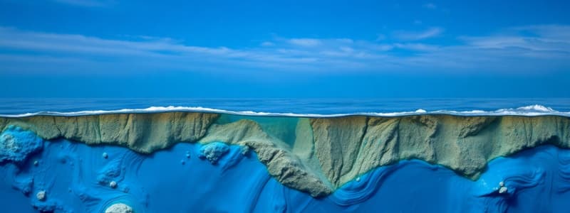
1.1.2 Continental Shelf
- The continental shelf is a shallow, gradually sloping area near the coast.
- Its seaward edge, the shelf break, marks a sharp drop-off to deeper ocean depths.
- Average width is approximately 65 km.
1.1.3 Ocean Basins and Abyssal Plains
- Beyond the continental shelf, the continental slope descends steeply to the abyssal plains.
- Abyssal plains are flat, wide areas of the deep-sea floor covered with sediment.
1.1.4 Ocean Ridges and Seamounts
- Ocean ridges are underwater mountain ranges where new seafloor forms.
- Seamounts are underwater volcanic peaks that may rise above sea level to form islands.
- Guyots are flat-topped seamounts.
1.1.5 Ocean Trenches
- Ocean trenches are the deepest parts of the ocean, falling below 6000 m.
- Found mainly around the rim of the Pacific Ocean.
- Formed where one tectonic plate subducts (slides beneath) another.
1.1.6 Driving Forces: Plate Tectonics
- Plate tectonics describes the movement of Earth's lithospheric plates.
- Mid-ocean ridges are associated with seafloor spreading, where new crust forms.
- Trenches are associated with subduction zones, where one plate slides beneath another.
1.3 Seabed Composition
- Ocean floor composition varies significantly.
- Terrigenous sediments are near land, originating from weathering and erosion.
- Pelagic sediments are far from land, primarily composed of skeletal remains of marine organisms.
1.3.1 Terrigenous Deposits
- Found near land, composed of various materials ranging from large boulders to fine clay.
- Composition affected by factors such as coastline, water movement, and seabed contours.
1.3.2 Pelagic Deposits
- Found in deep-water areas beyond the continental slope, primarily comprised of biogenic components.
- These areas can be rich in calcareous and/or siliceous material.
1.3.3 Deepsea (Polymetallic) Nodules
- Found on the ocean floor, mainly in deep water.
- Consist primarily of manganese, iron and other rarer metals.
1.4 Sediment Sampling
- Scientists use various methods including coring to study sediment.
- Methods vary depending on water depth and location.
- Techniques include gravity corers, piston corers, and sonar systems.
Box 1.1: Seabed 2030
- International project to complete mapping of the ocean floor by 2030.
- Using existing data and new technologies.
Box 1.2: The Kaikoura Canyon
- Deep submarine canyon in New Zealand.
- Rich in biodiversity, supporting species at depths not often explored.
Box 1.3: Visible Ridges
- Icelandic ridge that is an example of a segment of the Mid-Atlantic Ridge where the ridge is closely located near the surface.
Box 1.4: Five Deep Expeditions
- Expeditions used to explore the deepest points of the world's oceans.
- Used a purpose-built submersible and instruments.
Box 1.5: GLORIA
- Early side-scan sonar system.
- Contributed to mapping and detailed seabed visualization.
Studying That Suits You
Use AI to generate personalized quizzes and flashcards to suit your learning preferences.

