Podcast
Questions and Answers
What are the major physical features of India mentioned in the content?
What are the major physical features of India mentioned in the content?
The major physical features of India include the Himalayan Mountains, Northern Plains, Peninsular Plateau, Indian Desert, Coastal Plains, and Islands.
How do the Himalayan Mountains differ geologically from the Peninsular Plateau?
How do the Himalayan Mountains differ geologically from the Peninsular Plateau?
The Himalayas are geologically young and unstable, while the Peninsular Plateau is one of the oldest stable landmasses on Earth.
In what direction do the Himalayan Mountains stretch across India?
In what direction do the Himalayan Mountains stretch across India?
The Himalayan Mountains stretch in a west-east direction across northern India.
What is the significance of the altitudinal variations in the Himalayas?
What is the significance of the altitudinal variations in the Himalayas?
What type of rocks predominantly compose the Peninsular Plateau?
What type of rocks predominantly compose the Peninsular Plateau?
What forms the basis of the Northern Plains' formation?
What forms the basis of the Northern Plains' formation?
Describe the topographical features of the Himalayas.
Describe the topographical features of the Himalayas.
Identify the states where Mussoorie, Nainital, and Ranikhet are located.
Identify the states where Mussoorie, Nainital, and Ranikhet are located.
Name one glacier and one pass located in the Great Himalayas.
Name one glacier and one pass located in the Great Himalayas.
What are the outermost ranges of the Himalayas called?
What are the outermost ranges of the Himalayas called?
What is the altitude range of the Shiwaliks?
What is the altitude range of the Shiwaliks?
What marks the eastern-most boundary of the Himalayas?
What marks the eastern-most boundary of the Himalayas?
What are the valleys between the lesser Himalayas and the Shiwaliks known as?
What are the valleys between the lesser Himalayas and the Shiwaliks known as?
Name two hills included in the Purvachal region.
Name two hills included in the Purvachal region.
What type of rocks predominantly compose the hills in the Purvachal?
What type of rocks predominantly compose the hills in the Purvachal?
How are the divisions of the Himalayas marked on a regional basis?
How are the divisions of the Himalayas marked on a regional basis?
What factors contribute to the strategic importance of the Lakshadweep Islands?
What factors contribute to the strategic importance of the Lakshadweep Islands?
What is the significance of coral polyps in the formation of coral reefs?
What is the significance of coral polyps in the formation of coral reefs?
How do the unique physiographic units of India complement each other?
How do the unique physiographic units of India complement each other?
What led to the renaming of the Laccadive Islands to Lakshadweep in 1973?
What led to the renaming of the Laccadive Islands to Lakshadweep in 1973?
What environmental conditions are necessary for coral polyps to thrive?
What environmental conditions are necessary for coral polyps to thrive?
What are the names of the famous hill stations mentioned that are located in the Peninsular plateau?
What are the names of the famous hill stations mentioned that are located in the Peninsular plateau?
What is the geological origin of the black soil area known as Deccan Trap?
What is the geological origin of the black soil area known as Deccan Trap?
Which geographical feature lies on the western and northwestern margins of the Peninsular plateau?
Which geographical feature lies on the western and northwestern margins of the Peninsular plateau?
What are the three sections of the western coastal strip of India?
What are the three sections of the western coastal strip of India?
Which river is noted as the only large river in the Indian Desert region?
Which river is noted as the only large river in the Indian Desert region?
What climatic conditions are prevalent in the Indian Desert area?
What climatic conditions are prevalent in the Indian Desert area?
How does water typically behave in the streams during the rainy season in the Indian Desert?
How does water typically behave in the streams during the rainy season in the Indian Desert?
What distinguishes the Peninsular plateau from the surrounding coastal plains?
What distinguishes the Peninsular plateau from the surrounding coastal plains?
What is the rainfall level typically experienced by the Indian Desert region?
What is the rainfall level typically experienced by the Indian Desert region?
What characteristic do the hills of the Aravali range exhibit?
What characteristic do the hills of the Aravali range exhibit?
What are khadar and how do they contribute to agriculture in the floodplains?
What are khadar and how do they contribute to agriculture in the floodplains?
What is the significance of the Chotanagpur plateau in relation to the Damodar river?
What is the significance of the Chotanagpur plateau in relation to the Damodar river?
Describe the composition of the Peninsular Plateau.
Describe the composition of the Peninsular Plateau.
What distinguishes the Deccan Plateau from other plateaus in India?
What distinguishes the Deccan Plateau from other plateaus in India?
Identify and describe the two divisions of the Peninsular Plateau.
Identify and describe the two divisions of the Peninsular Plateau.
Where are the Garo, Khasi, and Jaintia Hills located?
Where are the Garo, Khasi, and Jaintia Hills located?
Explain the geographical significance of the Vindhyan range.
Explain the geographical significance of the Vindhyan range.
What role do the Western Ghats and Eastern Ghats play in the geography of the Deccan Plateau?
What role do the Western Ghats and Eastern Ghats play in the geography of the Deccan Plateau?
How does the physical geography of the Peninsular Plateau affect human activity?
How does the physical geography of the Peninsular Plateau affect human activity?
What is the relationship between calcareous deposits and soil in the mentioned region?
What is the relationship between calcareous deposits and soil in the mentioned region?
Flashcards
What are the Himalayas?
What are the Himalayas?
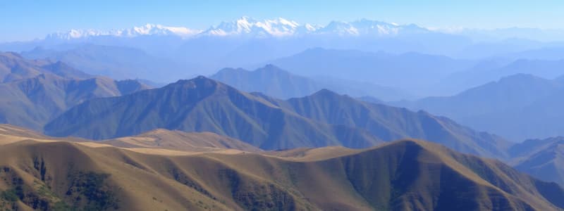
The Himalayas are a young mountain range that stretches across northern India, from the Indus to the Brahmaputra rivers. They are known for their high peaks, deep valleys, and fast-flowing rivers, making them a formidable natural barrier.
How are the Himalayas divided?
How are the Himalayas divided?
The Himalayas are divided into three parallel ranges, with valleys in between. These ranges are known for their significant altitudinal variations, which are greater in the eastern part of the Himalayas.
How are the Northern Plains formed?
How are the Northern Plains formed?
The Northern Plains of India are formed by the alluvial deposits carried by rivers like the Ganga and Yamuna. They are flat, fertile, and densely populated, making them ideal for agriculture.
What is the Deccan Plateau?
What is the Deccan Plateau?
Signup and view all the flashcards
What are the main physical features of India?
What are the main physical features of India?
Signup and view all the flashcards
Describe the physical variations of India.
Describe the physical variations of India.
Signup and view all the flashcards
Shiwaliks
Shiwaliks
Signup and view all the flashcards
Duns
Duns
Signup and view all the flashcards
Purvachal
Purvachal
Signup and view all the flashcards
Dehra Dun
Dehra Dun
Signup and view all the flashcards
Patkai Hills, Naga Hills, Manipur Hills, Mizo Hills
Patkai Hills, Naga Hills, Manipur Hills, Mizo Hills
Signup and view all the flashcards
Glaciers and Passes in the Great Himalayas
Glaciers and Passes in the Great Himalayas
Signup and view all the flashcards
States with Highest Himalayan Peaks
States with Highest Himalayan Peaks
Signup and view all the flashcards
Regional Divisions of the Himalayas
Regional Divisions of the Himalayas
Signup and view all the flashcards
Kotli Dun and Patli Dun
Kotli Dun and Patli Dun
Signup and view all the flashcards
What are the Lakshadweep Islands?
What are the Lakshadweep Islands?
Signup and view all the flashcards
Where is India's only active volcano located?
Where is India's only active volcano located?
Signup and view all the flashcards
What are coral reefs made of?
What are coral reefs made of?
Signup and view all the flashcards
What are the different types of coral reefs?
What are the different types of coral reefs?
Signup and view all the flashcards
Peninsular Plateau
Peninsular Plateau
Signup and view all the flashcards
Khadar
Khadar
Signup and view all the flashcards
Bhangar
Bhangar
Signup and view all the flashcards
Central Highlands
Central Highlands
Signup and view all the flashcards
Deccan Plateau
Deccan Plateau
Signup and view all the flashcards
Distributaries
Distributaries
Signup and view all the flashcards
Western Ghats
Western Ghats
Signup and view all the flashcards
Eastern Ghats
Eastern Ghats
Signup and view all the flashcards
Meghalaya Plateau
Meghalaya Plateau
Signup and view all the flashcards
Garo Hills
Garo Hills
Signup and view all the flashcards
What is the Deccan Trap?
What is the Deccan Trap?
Signup and view all the flashcards
What are Barchans?
What are Barchans?
Signup and view all the flashcards
Which river flows through the Indian desert?
Which river flows through the Indian desert?
Signup and view all the flashcards
What are the Aravali Hills?
What are the Aravali Hills?
Signup and view all the flashcards
What are the Western Coastal Plains?
What are the Western Coastal Plains?
Signup and view all the flashcards
What is the southern part of the Western Coastal Plains called?
What is the southern part of the Western Coastal Plains called?
Signup and view all the flashcards
What is another name for Udagamandalam?
What is another name for Udagamandalam?
Signup and view all the flashcards
Where are the Shevroy Hills and Javadi Hills located?
Where are the Shevroy Hills and Javadi Hills located?
Signup and view all the flashcards
What is the origin of the black soil in the Deccan Plateau?
What is the origin of the black soil in the Deccan Plateau?
Signup and view all the flashcards
Which mountain ranges are the youngest in India?
Which mountain ranges are the youngest in India?
Signup and view all the flashcards
Study Notes
Physical Features of India
- India is a vast country with varied landforms
- Major physical features include mountains, plains, deserts, plateaus, and islands
- The Peninsular Plateau is one of Earth's oldest landmasses, considered stable
- The Himalayas and Northern Plains are relatively recent landforms
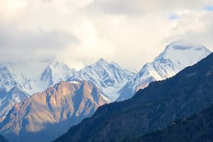
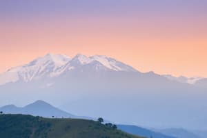
- The Himalayan Mountains are a young, folded mountain range running west-to-east
- The range is about 2,400 km long and its width varies from 150–400 km
- The Himalayas consist of three parallel ranges: the Great Himalayas, the Lesser Himalayas, and the Shivalik Hills
- The Great Himalayas are the loftiest, with an average height of 6,000 meters
- The Himalayas contain prominent peaks, such as Mount Everest
- The Northern Plains are formed of alluvial deposits from rivers, primarily the Indus, Ganges, and Brahmaputra
- These plains are fertile and densely populated
- The Indian Desert is characterized by sandy plains, low rainfall, and minimal vegetation
- The Coastal Plains lie along the coasts of the Indian peninsula
- India's eastern coastal plains are wider than the western ones
Major Physiographic Divisions
- Himalayan Mountains
- Northern Plains
- Peninsular Plateau
- Indian Desert
- Coastal Plains
- Islands
Studying That Suits You
Use AI to generate personalized quizzes and flashcards to suit your learning preferences.