Podcast
Questions and Answers
Que représente une carte topographique?
Que représente une carte topographique?
- Une représentation des frontières politiques des pays
- Une représentation en 3D de la surface de la Terre
- Une représentation des constellations et des étoiles
- Une représentation précise des caractéristiques physiques d'une zone donnée (correct)
Qu'est-ce que les lignes de contour représentent sur une carte topographique?
Qu'est-ce que les lignes de contour représentent sur une carte topographique?
- La vitesse du vent dans la région
- La densité de la population locale
- La hauteur du terrain à différents points (correct)
- La distribution des ressources naturelles
Qu'est-ce que les hachures représentent sur une carte topographique?
Qu'est-ce que les hachures représentent sur une carte topographique?
- Les falaises ou les dépressions abruptes (correct)
- Les frontières entre les différentes régions
- Les zones de forte densité de végétation
- Les anciennes voies de migration des animaux
Que représentent les points d'élévation sur une carte topographique?
Que représentent les points d'élévation sur une carte topographique?
Quel type de données les cartes topographiques montrent-elles principalement?
Quel type de données les cartes topographiques montrent-elles principalement?
Quel est l'un des avantages des cartes topographiques pour les amateurs de plein air?
Quel est l'un des avantages des cartes topographiques pour les amateurs de plein air?
Quel type de structures artificielles peut-on trouver sur les cartes topographiques?
Quel type de structures artificielles peut-on trouver sur les cartes topographiques?
Quel est l'un des types courants de cartes topographiques qui montre uniquement les données d'élévation?
Quel est l'un des types courants de cartes topographiques qui montre uniquement les données d'élévation?
Quel est l'un des bénéfices des cartes topographiques pour les géologues?
Quel est l'un des bénéfices des cartes topographiques pour les géologues?
Quel est l'un des bénéfices des cartes topographiques pour les planificateurs et ingénieurs?
Quel est l'un des bénéfices des cartes topographiques pour les planificateurs et ingénieurs?
Flashcards are hidden until you start studying
Study Notes
Exploring La Carte Topographique: A Comprehensive Guide
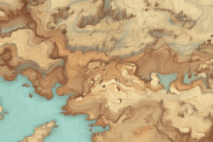
In the realm of cartography and geographical sciences, "La carte topographique" refers to a specific type of map that depicts the Earth's surface in intricate detail. These maps, often called topographic maps, offer an accurate representation of the physical features of a given area, providing valuable insights to geologists, planners, and outdoor enthusiasts alike.
A topographic map is essentially a two-dimensional representation of a three-dimensional space, portraying specific aspects of the landscape such as elevation, contours, vegetation, and man-made structures. This information is crucial for planning expeditions, assessing the impact of human development on the environment, and understanding the natural world.
Key Elements of La Carte Topographique
Topographic maps include the following features and details:
-
Contour lines: These lines represent the height of the land at different points, providing an at-a-glance view of the terrain's elevation.
-
Elevation points (contour intervals): These are the vertical distances between contour lines, assumed to be constant within each interval.
-
Hachures: These are short, angled lines used to represent steep slopes or depressions.
-
Spot heights: Individual points representing specific elevations on the map.
-
Isolines: These are lines that connect points of equal elevation, such as temperature, precipitation, or wind.
-
Hydrological features: These include rivers, lakes, and other bodies of water.
-
Vegetation: Forests, grasslands, and other types of vegetation are often depicted on topographic maps, providing clues about the local environment.
-
Man-made structures: These include roads, bridges, buildings, and other structures that might impact the landscape.
Benefits of La Carte Topographique
Topographic maps offer numerous benefits to various users:
-
Exploration and navigation: Topographic maps are the go-to tools for outdoor enthusiasts who wish to explore the wilderness. They help hikers, mountaineers, and geologists navigate through rugged terrain, plan routes, and avoid potential hazards.
-
Environmental assessment: Topographic maps play a vital role in assessing the impact of human development on the environment. They help planners and engineers design sustainable infrastructure that respects the natural landscape.
-
Land surveying: Topographic maps are essential for land surveyors, who use them to determine property boundaries, calculate distances, and assess the feasibility of construction projects.
-
Emergency response: Topographic maps are essential for emergency responders who need to navigate through unfamiliar territory in order to save lives.
-
Geological research: Topographic maps are an indispensable tool for geologists studying the Earth's surface, its geological history, and its natural resources.
Types of La Carte Topographique
Topographic maps come in various scales and levels of detail. Some of the most common types include:
-
Topographic maps: These are detailed geographic representations of a specific area, often used for navigation and land surveying.
-
Topographic quadrangles: These are topographic maps covering a specific area in a grid system.
-
Topographic base maps: These are simplified topographic maps showing only the most important features, often used for large-scale planning and analysis.
-
Contour maps: These are maps that show only the elevation data, using contour lines to represent different elevations.
-
Shaded relief maps: These are topographic maps where shading is used to represent elevation, providing a visual representation of the terrain's three-dimensionality.
Concluding Thoughts
La carte topographique is a valuable tool in the world of cartography and geography, offering an accurate representation of the Earth's surface and its physical features. These maps help outdoor enthusiasts explore and navigate the wilderness, planners assess the impact of human development on the environment, geologists study the Earth's natural history, and emergency responders save lives. With their intricate details and key elements, topographic maps are invaluable resources that provide unique insights into the natural world.
So, the next time you plan an expedition, navigate a new trail, or assess the impact of a construction project, remember the importance of the topographic map and its role in our understanding of the Earth's surface.
Studying That Suits You
Use AI to generate personalized quizzes and flashcards to suit your learning preferences.