Podcast
Questions and Answers
What is the main focus of topographic maps?
What is the main focus of topographic maps?
- Illustrating natural features only
- Illustrating man-made features only
- Illustrating large flat areas
- Illustrating both man-made and natural features (correct)
What do contour lines represent on topographic maps?
What do contour lines represent on topographic maps?
- Relief and elevation (correct)
- Transportation networks
- Hydrographic features
- Vegetation areas
What feature does hydrography represent on topographic maps?
What feature does hydrography represent on topographic maps?
- Lakes, rivers, streams, and swamps (correct)
- Transportation networks
- Relief and elevation
- Vegetation areas
What is the structure of topographic maps characterized by?
What is the structure of topographic maps characterized by?
What are some of the purposes for which topographic maps are essential tools?
What are some of the purposes for which topographic maps are essential tools?
What do contour lines on a topographic map represent?
What do contour lines on a topographic map represent?
How are symbols used on a topographic map?
How are symbols used on a topographic map?
What is the purpose of a legend on a topographic map?
What is the purpose of a legend on a topographic map?
How are topographic maps used in civil engineering?
How are topographic maps used in civil engineering?
Why are topographic maps important for outdoor adventures?
Why are topographic maps important for outdoor adventures?
Flashcards are hidden until you start studying
Study Notes
Representation of Geographical Features: Topographic Maps
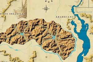
Topographic maps are a type of cartographic representation that focuses on the detailed and accurate illustration of both man-made and natural features on the ground, such as roads, railways, power transmission lines, contours, elevations, rivers, and large flat areas. These maps are characterized by large-scale detail and the use of contour lines to represent relief. They are an essential tool for various purposes, including civil engineering, planning, and outdoor adventures.
Features of Topographic Maps
Topographic maps consist of several elements that help represent the Earth's surface features accurately and to scale on a two-dimensional surface. Some of the key features include:
- Relief: Topographic maps depict natural features such as mountains, valleys, slopes, and depressions, as defined by contours.
- Hydrography: These maps show lakes, rivers, streams, swamps, rapids, and falls.
- Vegetation: Wooded areas and other vegetation are represented on topographic maps.
- Transportation: Roads, trails, railways, and other transportation networks are included.
Structure of Topographic Maps
Topographic maps have a comprehensive and detailed structure that includes the following aspects:
- Contour Lines: These are imaginary lines that join points of equal elevation on the Earth's surface above or below a reference surface, such as mean sea level. Contours make it possible to measure the height of mountains, depths of ocean bottoms, and steepness of slopes.
- Symbols: Maps use symbols, lettering, and diagrams to represent specific features or objects. These symbols can be points, lines, or areas, depending on the size and extent of the features.
- Legends: Topographic maps include a legend that provides information on the meaning of the symbols and other visual elements on the map.
Uses of Topographic Maps
Topographic maps are used for various purposes, such as:
- Civil Engineering: They provide detailed information on the Earth's surface, which is essential for planning and designing infrastructure projects.
- Government Planning: Topographic maps can be used for administrative purposes, helping governments create policies and plans for land use and development.
- Outdoor Adventures: These maps are an excellent guide for outdoor enthusiasts, as they can help plan routes, locate campsites, and navigate terrain.
- Education: Topographic maps can be used to teach geographical features, elevation levels, and other scientific concepts.
In conclusion, topographic maps play a crucial role in representing the Earth's geographical features and are an essential tool for various applications, from civil engineering to outdoor adventures. By understanding the features and structure of topographic maps, individuals can better appreciate the natural and man-made elements of the Earth's surface and make informed decisions based on the information these maps provide.
Studying That Suits You
Use AI to generate personalized quizzes and flashcards to suit your learning preferences.