Podcast
Questions and Answers
Which mountain range forms a significant northern boundary of India, and includes Mount Everest?
Which mountain range forms a significant northern boundary of India, and includes Mount Everest?
- Vindhya Range
- Himalayan Mountains (correct)
- Western Ghats
- Deccan Plateau
The Indo-Gangetic Plain is best characterized by which of the following?
The Indo-Gangetic Plain is best characterized by which of the following?
- A region with high volcanic activity.
- A coastal area with mangrove forests.
- A mountainous region with limited agriculture.
- A fertile alluvial plain, formed by major river systems. (correct)
Which geographical feature is known for its diverse geological formations and covers a major portion of southern India?
Which geographical feature is known for its diverse geological formations and covers a major portion of southern India?
- Thar Desert
- Deccan Plateau (correct)
- Konkan Coast
- Indo-Gangetic Plain
What is the most significant factor influencing India's monsoon climate?
What is the most significant factor influencing India's monsoon climate?
Which of the following is NOT a major river in India?
Which of the following is NOT a major river in India?
Which of these natural resources is NOT specifically mentioned as being present in India?
Which of these natural resources is NOT specifically mentioned as being present in India?
India’s high level of biodiversity is primarily attributed to which combination of factors?
India’s high level of biodiversity is primarily attributed to which combination of factors?
What is the primary significance of India's river systems?
What is the primary significance of India's river systems?
Flashcards
What is the Deccan Plateau?
What is the Deccan Plateau?
A large, stable plateau covering much of southern India, known for its diverse geological formations.
What are monsoons?
What are monsoons?
The seasonal shift of winds, called monsoons, heavily impacts rainfall patterns, bringing significant rainfall to India during a specific period of the year.
What is the Indo-Gangetic Plain?
What is the Indo-Gangetic Plain?
This fertile plain is formed by the Indus, Ganges, and Brahmaputra rivers and is crucial for agricultural activities in India.
What are the Himalayan Mountains?
What are the Himalayan Mountains?
Signup and view all the flashcards
What are India's coastal regions?
What are India's coastal regions?
Signup and view all the flashcards
What are India's natural resources?
What are India's natural resources?
Signup and view all the flashcards
How is India's administrative structure organized?
How is India's administrative structure organized?
Signup and view all the flashcards
Explain India's biodiversity.
Explain India's biodiversity.
Signup and view all the flashcards
Study Notes
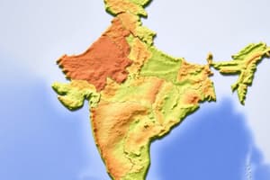
Location and Size
- India is located in South Asia, bordered by the Indian Ocean on the south.
- It shares land borders with Pakistan, Afghanistan, China, Nepal, Bhutan, Bangladesh, and Myanmar.
- India covers an area of approximately 3.28 million square kilometers.
Physical Features
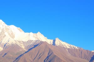
- Himalayan Mountains: A significant mountain range, forming a northern boundary and influencing the climate. Includes the highest peaks in the world, like Mount Everest.
- Indo-Gangetic Plain: A fertile alluvial plain formed by the Indus, Ganges, and Brahmaputra rivers. This region is crucial for agriculture.
- Deccan Plateau: A large, stable plateau covering much of southern India, known for its diverse geological formations.
- Coastal Regions: India has a long coastline stretching along the Arabian Sea and the Bay of Bengal, with numerous beaches and coastal plains. This includes the Konkan, Malabar, and Coromandel coasts.
- Deserts: The Thar Desert, located in western India, is a significant arid region.
Climate
- India's climate is diverse, influenced by its vast size and varied topography.
- Monsoon Climate: The seasonal shift of winds, called monsoons, heavily impacts rainfall patterns.
- Tropical Climate: Significant parts of the country experience tropical climates, with varying degrees of humidity and temperature.
- Different regions: Specific features like the Himalayas and the Deccan Plateau, along with proximity to the sea, contribute to varied local climates.
Rivers
- Major rivers include the Indus, Ganges, Brahmaputra, Godavari, Krishna, Narmada, and Kaveri, which play a vital role for irrigation, transportation, and water resources.
- River basins are crucial for agricultural activities.
- River systems often mark boundaries or form significant ecological features.
Natural Resources
- India possesses diverse natural resources including coal, iron ore, bauxite, manganese, and petroleum.
- Geographic factors and natural formations affect the distribution of these resources.
- The resources are imperative for the national economy and industrial development.
Biodiversity
- India is known for its rich biodiversity.
- The country has high levels of species richness, reflecting the diverse geographical features and varied climates.
- From tropical rainforests to alpine meadows, the landscape supports a wide range of plant and animal species.
Administrative Divisions
- India is divided into states and union territories.
- The administrative divisions reflect the historical and geographical features of different parts of the country.
- These divisions play a key role in governance and resource management.
Islands
- India has island territories, including Lakshadweep, and Andaman and Nicobar Islands.
- These islands offer unique ecological environments and aspects of the marine ecosystem.
Studying That Suits You
Use AI to generate personalized quizzes and flashcards to suit your learning preferences.