Podcast
Questions and Answers
What role do the Himalayas play in India's geography?
What role do the Himalayas play in India's geography?
- They are primarily a desert region.
- They are known for their agricultural output.
- They are a source of freshwater for several rivers. (correct)
- They serve as a barrier to monsoon winds.
Which of the following statements accurately describes the Deccan Plateau?
Which of the following statements accurately describes the Deccan Plateau?
- It is primarily characterized by coastal ecosystems.
- It is known for high mineral deposits.
- It is predominantly a desert area.
- It serves as a major agricultural region for cotton and sugarcane. (correct)
How does the climate of India influence its economy?
How does the climate of India influence its economy?
- It shapes agricultural practices and resource management. (correct)
- It has no significant impact on agriculture.
- It determines the location of manufacturing industries.
- It only affects coastal trade routes.
What is a significant characteristic of the Thar Desert?
What is a significant characteristic of the Thar Desert?
What major benefit do India's coastal plains provide?
What major benefit do India's coastal plains provide?
Which point is the easternmost point of India?
Which point is the easternmost point of India?
What type of climate does India experience in its northern mountainous region?
What type of climate does India experience in its northern mountainous region?
Which river system contributes significantly to one of the largest river deltas in the world?
Which river system contributes significantly to one of the largest river deltas in the world?
Which mountain range forms the northern boundary of India?
Which mountain range forms the northern boundary of India?
Which of the following vegetation types is not predominant in India?
Which of the following vegetation types is not predominant in India?
What geographical feature primarily characterizes the Indo-Gangetic Plain?
What geographical feature primarily characterizes the Indo-Gangetic Plain?
Which coastal plain runs along the eastern shoreline of India?
Which coastal plain runs along the eastern shoreline of India?
What role does the southwest monsoon play in India?
What role does the southwest monsoon play in India?
Flashcards
Indo-Gangetic Plain's role
Indo-Gangetic Plain's role
The Indo-Gangetic Plain is very important for farming in India.
India's landforms
India's landforms
India has various landforms (like plains, plateaus, mountains, etc.) that affect the area's characteristics.
Himalayas' water source
Himalayas' water source
The Himalayas provide freshwater to many rivers.
Deccan Plateau's crops
Deccan Plateau's crops
Signup and view all the flashcards
Impact of climate on India
Impact of climate on India
Signup and view all the flashcards
India's Northernmost Point
India's Northernmost Point
Signup and view all the flashcards
India's Southernmost Point
India's Southernmost Point
Signup and view all the flashcards
Himalayas
Himalayas
Signup and view all the flashcards
Indo-Gangetic Plain
Indo-Gangetic Plain
Signup and view all the flashcards
Deccan Plateau
Deccan Plateau
Signup and view all the flashcards
Monsoon Season
Monsoon Season
Signup and view all the flashcards
Major River
Major River
Signup and view all the flashcards
Coastal Plains
Coastal Plains
Signup and view all the flashcards
Study Notes
Geographical Extremes
- India is situated in the northern hemisphere, between latitudes 8°4' north to 37°6' north and longitudes 68°7' east to 97°25' east.
- The country's northernmost point is Indira Col, and the southernmost point is Kanyakumari.
- The westernmost point is the Mandvi Point, and the easternmost point is the Kibithoo Point.
Major Physical Divisions
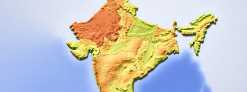
- The Himalayas constitute the northern mountain ranges, shaping the country's northern boundary.
- The Indo-Gangetic Plain is a vast fertile land stretching between the Himalayas and the Thar Desert.
- The Deccan Plateau forms the south of the country, characterized by its large expanse and varied topography.
- The coastal plains, including the Konkan, Malabar, and Coromandel coasts, run along the western and eastern shorelines.
- The Thar Desert, or Great Indian Desert, occupies a significant portion of northwestern India.
- The Western Ghats and Eastern Ghats are hill ranges that run parallel to the western and eastern coastal plains, respectively.
Rivers and Water Bodies
- Major rivers like the Ganga, Indus, Brahmaputra, Godavari, Krishna, and Kaveri have significant roles in India's hydrology and agriculture.
- The Ganga-Brahmaputra-Meghna delta is one of the largest river deltas globally, providing fertile land for agriculture.
- Numerous lakes and wetlands, like Chilika Lake and Sambhar Lake, are vital for biodiversity and local communities.
- The country has long coastlines, offering access to the Arabian Sea and the Bay of Bengal.
Climate
- India's climate is diverse, ranging from tropical monsoonal to arid and semi-arid in different parts.
- The monsoon season, driven by the southwest monsoon winds, is crucial for agriculture in most parts of the country.
- Variations in temperature and rainfall across the country are significantly influenced by latitude, altitude, and proximity to the sea.
- The Himalayan region experiences a colder climate than the coastal areas.
Vegetation and Wildlife
- India's diverse climate supports a wide array of flora and fauna.
- Tropical rainforests, deciduous forests, and coniferous forests are among the dominant vegetation types.
- The country is home to a wealth of wildlife, including tigers, elephants, rhinoceros, and diverse bird species.
- National parks and wildlife sanctuaries are designated to protect and conserve this rich biodiversity.
Important Geographical Features
- The Himalayas are a significant source of freshwater for numerous rivers.
- The Thar Desert is known for its unique flora and fauna adapted to the arid conditions.
- The Deccan Plateau is a major agricultural area, particularly for crops like cotton and sugarcane.
- India's coastal plains offer diverse ecosystems, harboring coastal wildlife and important ports.
Geographical Impact on Economy
- The fertile Indo-Gangetic Plain is crucial for agricultural production.
- The location and resources influence India's economy, from agriculture to trade to industries like steel and textiles.
- The country's climate plays an essential role in shaping agricultural practices, resource management, and infrastructure development.
- Availability of mineral resources influences the industrial sector.
- Water resources are essential for irrigation and hydropower.
Landforms
- India comprises diverse landforms like plains, plateaus, mountains, and deserts, each with unique characteristics.
- The varied topography has shaped the country's cultural and social landscapes.
- The contrasting landforms influence the lifestyles of the people living in those areas.
Studying That Suits You
Use AI to generate personalized quizzes and flashcards to suit your learning preferences.


