Podcast
Questions and Answers
Match the following geographical features with their descriptions:
Match the following geographical features with their descriptions:
Himalayas = Forms India's northwestern border with China, Nepal, and Bhutan Deccan Plateau = Vast, uplifted region covering approximately 600,000 square kilometers in western and central India Mount Everest = World's highest peak located in the Himalayas Kangchenjunga = One of the top five highest mountains on Earth, located in the Himalayas
Match the following rivers with their origins in the Himalayas:
Match the following rivers with their origins in the Himalayas:
Brahmaputra = Originates in the Himalayas Ganges = Originates in the Himalayas Yamuna = Originates in the Himalayas Mahanadi = Does not originate in the Himalayas
Match the following terms with their corresponding regions:
Match the following terms with their corresponding regions:
Roof of the World = Refers to the Himalayas Monolithic rock formation = Characteristic of the Deccan Plateau Lush tropical forests = Found in various parts of India Low-lying, flat topography = Feature of the Deccan Plateau
Match the following geological events with their respective outcomes:
Match the following geological events with their respective outcomes:
Match the following terms with their descriptions:
Match the following terms with their descriptions:
Match the following features with their locations:
Match the following features with their locations:
Match the following statements with the correct river system:
Match the following statements with the correct river system:
Match the following with their characteristics:
Match the following with their characteristics:
Flashcards
Himalayas
Himalayas
A mountain range forming India's northwestern border, home to the world's highest peaks.
Deccan Plateau
Deccan Plateau
A large, uplifted region in western and central India, formed by ancient lava flows.
Indian Peninsula
Indian Peninsula
Southern India, a mix of mountains, plateaus, and plains.
River Systems (India)
River Systems (India)
Signup and view all the flashcards
Andaman and Nicobar Islands
Andaman and Nicobar Islands
Signup and view all the flashcards
Lakshadweep Islands
Lakshadweep Islands
Signup and view all the flashcards
Western Ghats
Western Ghats
Signup and view all the flashcards
Eastern Ghats
Eastern Ghats
Signup and view all the flashcards
Study Notes
India's Land and Terrain
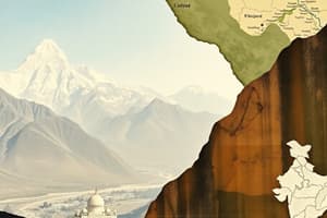
Spanning across 3.28 million square kilometers, India is the seventh-largest country in the world, occupying a diverse and complex landscape that captivates with its vast geographical expanse. From the snow-capped peaks of the Himalayas to the lush tropical forests, the nation's terrain teems with a myriad of topographical features.
The Himalayas
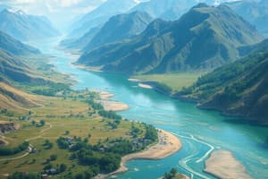
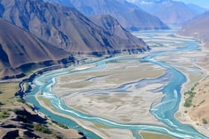
The Himalayas, commonly referred to as the "Roof of the World," form India's northwestern border with China, Nepal, and Bhutan. This towering mountain range is home to the world's highest peak, Mount Everest, and its neighboring peaks, K2 and Kangchenjunga, which are also among the top five highest mountains on Earth. Not only do the Himalayas provide a natural barrier to invasion, but they also contribute to the formation of India's eastern rivers, including the Brahmaputra, Ganges, and Yamuna, which are crucial for providing water for irrigation, fishing, and hydropower generation.
The Deccan Plateau
The Deccan Plateau, also known as the Deccan Traps, is a vast, uplifted region that covers approximately 600,000 square kilometers in western and central India. The plateau is a geological wonder, formed about 65 million years ago by the extrusion of lava flows from the Earth's mantle. This ancient process has resulted in the formation of a massive monolithic rock formation that averages about 2 kilometers in depth, creating a high, relatively flat region that has a low-lying, flat topography.
The Indian Peninsula
The Indian Peninsula, as the name suggests, forms the southern portion of the nation, extending southward from the Vindhya Mountains, which separate it from the Deccan Plateau. The peninsula is the youngest landmass in India, with a complex jigsaw puzzle of folded mountains, plateaus, and plains. The Western Ghats, also known as the Sahyadris, mark the western border of the peninsula, while the Eastern Ghats run parallel to the coast in the east. Between these mountain ranges lies the coastal plains, which are heavily populated and rich in agricultural resources.
The River Systems
India's river systems are among the most significant geographical features of the nation, providing vital sources of water for irrigation, transportation, and hydropower generation. The three major river systems are the Ganges-Brahmaputra-Meghna basin, the Godavari-Krishna-Kaveri basin, and the Koshik-Tapti basin. Many of India's rivers originate in the Himalayas, with the Ganges and Brahmaputra being the two longest rivers in the nation. The rivers of India have shaped the nation's civilizations, serving as natural arteries that have facilitated trade and travel throughout the subcontinent.
The Islands
In addition to the mainland, India also comprises a significant number of islands, scattered across the Bay of Bengal, the Andaman Sea, and the Arabian Sea. The largest island group, the Andaman and Nicobar Islands, is located in the Bay of Bengal, while the Lakshadweep Islands are situated off the southwestern coast in the Arabian Sea. These island territories are rich in biodiversity, with diverse marine life and unique tropical forests, making them a popular destination for ecotourism and scientific exploration.
India's geography is a tapestry of rugged mountains, rolling plains, and intricate river systems that have shaped the nation's culture, civilization, and development. Each feature of the landscape provides a unique perspective into the vast breadth of the nation, forming the foundation of India's identity and its rich history.
Studying That Suits You
Use AI to generate personalized quizzes and flashcards to suit your learning preferences.