Podcast
Questions and Answers
What is responsible for the movement of glaciers?
What is responsible for the movement of glaciers?
- Wind and precipitation
- Solar flares and cosmic rays
- Earthquakes and volcanoes
- Pressure underneath and gravity (correct)
Glaciers are formed very quickly, sometimes within a few months.
Glaciers are formed very quickly, sometimes within a few months.
False (B)
What are the ridges of till left behind by a retreating glacier known as?
What are the ridges of till left behind by a retreating glacier known as?
moraines
When blocks of ice separate from glaciers, get buried, and melt, they form ______.
When blocks of ice separate from glaciers, get buried, and melt, they form ______.
Match the geologic era with a significant event that occurred in that era:
Match the geologic era with a significant event that occurred in that era:
What is a characteristic of till plains that make them very useful?
What is a characteristic of till plains that make them very useful?
Plate tectonics and glaciation both started in the Paleozoic era.
Plate tectonics and glaciation both started in the Paleozoic era.
During which era did the Canadian Shield form?
During which era did the Canadian Shield form?
Which geological feature is commonly formed at divergent plate boundaries?
Which geological feature is commonly formed at divergent plate boundaries?
Transform plate boundaries are characterized by the creation of new lithosphere.
Transform plate boundaries are characterized by the creation of new lithosphere.
What is the average speed at which tectonic plates move?
What is the average speed at which tectonic plates move?
The layer beneath the lithosphere is called the ________.
The layer beneath the lithosphere is called the ________.
Match the plate boundary type with the geological feature it commonly forms:
Match the plate boundary type with the geological feature it commonly forms:
What happens when two continental plates converge?
What happens when two continental plates converge?
Magma does not come up at divergent boundaries.
Magma does not come up at divergent boundaries.
What two components make up the lithosphere?
What two components make up the lithosphere?
Who proposed the theory of continental drift?
Who proposed the theory of continental drift?
The theory of continental drift explains the force behind the movement of continents.
The theory of continental drift explains the force behind the movement of continents.
What was the name of the supercontinent that existed about 300 million years ago?
What was the name of the supercontinent that existed about 300 million years ago?
The plates of the Earth float on a layer of rock known as the ______.
The plates of the Earth float on a layer of rock known as the ______.
Match the following theories with their descriptions:
Match the following theories with their descriptions:
Which of the following was NOT an evidence used by Wegener to support his theory of continental drift?
Which of the following was NOT an evidence used by Wegener to support his theory of continental drift?
Plate Tectonics Theory was created before the Continental Drift Theory.
Plate Tectonics Theory was created before the Continental Drift Theory.
What force, identified by the Plate Tectonics Theory, causes the movement of the plates?
What force, identified by the Plate Tectonics Theory, causes the movement of the plates?
Which landform region is known as Canada's 'Bread Basket'?
Which landform region is known as Canada's 'Bread Basket'?
The Western Cordillera was formed by the collision of the North American Plate and the African Plate.
The Western Cordillera was formed by the collision of the North American Plate and the African Plate.
What type of rock is primarily found in the Canadian Shield?
What type of rock is primarily found in the Canadian Shield?
The Great Lakes are located in basins gouged out by the ________.
The Great Lakes are located in basins gouged out by the ________.
Match the landform region with its description:
Match the landform region with its description:
Which of the following was NOT created/shaped by glaciers?
Which of the following was NOT created/shaped by glaciers?
The sedimentary rock in the Appalachian mountains is rich in metallic minerals such as iron and zinc.
The sedimentary rock in the Appalachian mountains is rich in metallic minerals such as iron and zinc.
What makes the Great Lakes-St. Lawrence Lowlands well-suited for farming?
What makes the Great Lakes-St. Lawrence Lowlands well-suited for farming?
Which of the following best describes the Hudson Bay and Arctic Lowlands?
Which of the following best describes the Hudson Bay and Arctic Lowlands?
The Innuitian Mountains are older than the Appalachian Mountains.
The Innuitian Mountains are older than the Appalachian Mountains.
Why is the Canadian Shield sparsely populated?
Why is the Canadian Shield sparsely populated?
A climate graph describes the basic climate characteristics of __________ and __________.
A climate graph describes the basic climate characteristics of __________ and __________.
Match the following descriptions with the correct term:
Match the following descriptions with the correct term:
Which of these factors is NOT mentioned as a reason why the Canadian Shield is sparsely populated?
Which of these factors is NOT mentioned as a reason why the Canadian Shield is sparsely populated?
Weather is easy to predict more than 5 days in advance.
Weather is easy to predict more than 5 days in advance.
What two measurements are used to create climate graphs?
What two measurements are used to create climate graphs?
What is the primary direction of air movement that constitutes wind?
What is the primary direction of air movement that constitutes wind?
Higher elevations generally experience warmer temperatures compared to lower elevations.
Higher elevations generally experience warmer temperatures compared to lower elevations.
What is the rate at which air cools as it rises before condensation occurs?
What is the rate at which air cools as it rises before condensation occurs?
The process of water changing from a gas to a liquid is known as ________.
The process of water changing from a gas to a liquid is known as ________.
Match the following locations with their climate characteristics:
Match the following locations with their climate characteristics:
Which of the following best describes a 'modified continental' climate?
Which of the following best describes a 'modified continental' climate?
Mountain ranges generally do not cause any significant changes in weather patterns.
Mountain ranges generally do not cause any significant changes in weather patterns.
What is the term for a mass of debris deposited by a glacier?
What is the term for a mass of debris deposited by a glacier?
Flashcards
Continental Drift Theory
Continental Drift Theory
Proposed in 1912 by Alfred Wegener, the theory explains how continents moved to their current positions. It states that all landmasses were once joined together as a supercontinent called Pangaea, which broke up and drifted apart over millions of years.
Pangaea
Pangaea
The supercontinent that existed around 300 million years ago, formed by the collision of all the continents.
Continental Drift
Continental Drift
The process by which the continents moved apart from Pangaea, starting around 200 million years ago.
Aesthenosphere
Aesthenosphere
Signup and view all the flashcards
Convection Currents
Convection Currents
Signup and view all the flashcards
Plate Tectonics Theory
Plate Tectonics Theory
Signup and view all the flashcards
Tectonic Plates
Tectonic Plates
Signup and view all the flashcards
Plate Boundaries
Plate Boundaries
Signup and view all the flashcards
Divergent Boundaries
Divergent Boundaries
Signup and view all the flashcards
Convergent Boundaries
Convergent Boundaries
Signup and view all the flashcards
Oceanic Trench
Oceanic Trench
Signup and view all the flashcards
Volcanic Arcs
Volcanic Arcs
Signup and view all the flashcards
Mountain Chains
Mountain Chains
Signup and view all the flashcards
Transform Boundaries
Transform Boundaries
Signup and view all the flashcards
Lithosphere
Lithosphere
Signup and view all the flashcards
Moraine
Moraine
Signup and view all the flashcards
Terminal Moraine
Terminal Moraine
Signup and view all the flashcards
Kettle Lake
Kettle Lake
Signup and view all the flashcards
Till Plain
Till Plain
Signup and view all the flashcards
Glacial Activity
Glacial Activity
Signup and view all the flashcards
Glacial Erosion
Glacial Erosion
Signup and view all the flashcards
Paleozoic Era
Paleozoic Era
Signup and view all the flashcards
Cenozoic Era
Cenozoic Era
Signup and view all the flashcards
Western Cordillera
Western Cordillera
Signup and view all the flashcards
Interior Plains
Interior Plains
Signup and view all the flashcards
Canadian Shield
Canadian Shield
Signup and view all the flashcards
Great Lakes-St. Lawrence Lowlands
Great Lakes-St. Lawrence Lowlands
Signup and view all the flashcards
Appalachian Mountains
Appalachian Mountains
Signup and view all the flashcards
Sedimentary Rock Formation
Sedimentary Rock Formation
Signup and view all the flashcards
Tectonic Plate Collision
Tectonic Plate Collision
Signup and view all the flashcards
Hudson Bay & Arctic Lowlands
Hudson Bay & Arctic Lowlands
Signup and view all the flashcards
Innuitian Mountains
Innuitian Mountains
Signup and view all the flashcards
Why is the Canadian Shield sparsely populated?
Why is the Canadian Shield sparsely populated?
Signup and view all the flashcards
Weather
Weather
Signup and view all the flashcards
Climate
Climate
Signup and view all the flashcards
Climate Graph
Climate Graph
Signup and view all the flashcards
Continental Climate
Continental Climate
Signup and view all the flashcards
Maritime Climate
Maritime Climate
Signup and view all the flashcards
High Pressure Areas
High Pressure Areas
Signup and view all the flashcards
Low Pressure Areas
Low Pressure Areas
Signup and view all the flashcards
What causes wind?
What causes wind?
Signup and view all the flashcards
Why is it cold at high elevations?
Why is it cold at high elevations?
Signup and view all the flashcards
Rate of Air Cooling
Rate of Air Cooling
Signup and view all the flashcards
What is Condensation?
What is Condensation?
Signup and view all the flashcards
How do Mountains Affect Precipitation?
How do Mountains Affect Precipitation?
Signup and view all the flashcards
How do Large Bodies of Water Affect Climate?
How do Large Bodies of Water Affect Climate?
Signup and view all the flashcards
Study Notes
Continental Drift Theory
- Explains how continents are in their current positions
- Created by Alfred Wegener in 1912
- 300 million years ago (mya): all landmasses were in constant motion
Plate Tectonics Theory
- Built on continental drift theory
- Earth's outer shell is made up of individual plates that move
- 7 major plates, 8 secondary plates and 60 minor plates
- Plates float on a layer of rock called the asthenosphere
- Convection currents in the Earth's core cause the plates to move
Divergent Boundaries
- Plates move away from each other
- Magma rises, creating new crust
- Landforms formed include rift valleys and mid-ocean ridges
- Example: mid-Atlantic ridge, Iceland
Convergent Boundaries
- Plates move toward each other
- If plates have equal density: mountains form
- If plates have unequal density: subduction occurs (one plate slides under another)
- Types: oceanic-oceanic, oceanic-continental, continental-continental
- Features: volcanic island arcs, trenches, volcanoes, mountains
Transform Boundaries
- Plates slide past each other
- Creates earthquakes
Igneous Rocks
- Formed when magma or lava cools and hardens
- Intrusive rocks cool below the surface (large crystals)
- Extrusive rocks cool above the surface (small crystals)
- Examples: granite, basalt, obsidian, pumice
Sedimentary Rocks
- Formed from compaction and cementation of sediments (like sand, clay and silt)
- Found in various locations across Canada (Interior Plains, Great Lakes etc.)
- Contain deposits of fossil fuels
- Examples: sandstone, limestone, shale
Metamorphic Rocks
- Formed when igneous or sedimentary rocks are subjected to heat and pressure
- Examples: slate, marble, gneiss
Economic Importance of Minerals
- Minerals have various uses/applications (ex. Glass production, fertilizers, steel making etc.)
- Example Minerals: Quartz, Talc, Graphite, Fluorite, Barite, Apatite, etc.
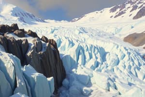
Glaciation
- The process of ice advancing and retreating over land
- Glaciers advance = get larger
- Glaciers retreat = get smaller
- Effects: landforms like moraines, kettle lakes, and till plains
- Formation of moraines: ridges of till left as a glacier retreats (medials and terminal moraines)
- Formation of Kettle lakes: Ice blocks are left behind from retreating glaciers creating cavities which fill up with water.
Canadian Geologic Time Periods
- Precambrian Era (4.6 billion - 570 million years ago): Canadian shield formation
- Paleozoic Era (570 - 245 million years ago): Formation of Interior plains, Western Cordilleras and Appalachians
- Mesozoic Era (245 - 66 million years ago): Continents moved / breakup of Pangaea etc.
- Cenozoic Era (66 million years ago - present): Glaciation shaping Appalachian and Canadian Shield
Weather and Climate
- Weather: short-term atmospheric conditions
- Climate: long-term weather patterns (years).
- Factors that determine climate: Latitude, Ocean Currents, Wind, Elevation
- Climate regions in Canada: Arctic, Taiga, Maritime, Pacific Coastal etc.
Canadian Landforms
- Western Cordillera: high, sharp-peaked mountains (separated by plateaus and valleys)
- Interior Plains: flatlands, fertile soil, rich in mineral deposits
- Canadian Shield: relatively flat, rounded hills of igneous and metamorphic rock
- Great Lakes-St. Lawrence Lowlands: large deposits, flat plains, good for farming
- Appalachian Mountains: rounded hills, wetlands, lakes, slopes
- Hudson Bay & Arctic Lowlands: low-lying areas, sedimentary rock
Studying That Suits You
Use AI to generate personalized quizzes and flashcards to suit your learning preferences.