Podcast
Questions and Answers
Which mountain range is known for being the youngest and highest in the world?
Which mountain range is known for being the youngest and highest in the world?
- Himalayas (correct)
- Aravalli Range
- Western Ghats
- Eastern Ghats
Which plateau is known for its volcanic rock and is situated in southern India?
Which plateau is known for its volcanic rock and is situated in southern India?
- Deccan Plateau (correct)
- Chota Nagpur Plateau
- Malwa Plateau
- Tibetan Plateau
What is the primary climatic characteristic of the tropical monsoon zone in India?
What is the primary climatic characteristic of the tropical monsoon zone in India?
- Year-round rainfall
- Constant high temperatures
- Frequent natural disasters
- Regular seasonal monsoons (correct)
What type of climate predominates in the northwest region of India, including the Thar Desert?
What type of climate predominates in the northwest region of India, including the Thar Desert?
Which of the following rivers is considered sacred and crucial for cultural practices in India?
Which of the following rivers is considered sacred and crucial for cultural practices in India?
Which coastal area in India is known for its sandy beaches and backwaters?
Which coastal area in India is known for its sandy beaches and backwaters?
Which of the following features is a characteristic of the Indo-Gangetic Plain?
Which of the following features is a characteristic of the Indo-Gangetic Plain?
Which mountain range is known for its rich biodiversity and unique ecosystems along the coasts of India?
Which mountain range is known for its rich biodiversity and unique ecosystems along the coasts of India?
Which river is noted for its strong currents and floodplains in northeastern India?
Which river is noted for its strong currents and floodplains in northeastern India?
What type of ecosystem is primarily found in arid regions of northwest India, such as the Thar Desert?
What type of ecosystem is primarily found in arid regions of northwest India, such as the Thar Desert?
Study Notes
Geography Study Notes
Physical Geography
- Definition: Study of naturally occurring spatial patterns and processes on Earth’s surface.
- Key Components:
- Landforms: Mountains, valleys, plains, plateaus, and hills.
- Climate: Patterns of temperature, precipitation, and wind; influenced by latitude, altitude, and proximity to water.
- Vegetation: Types of ecosystems and biodiversity based on climate and soil types (e.g., forests, grasslands, deserts).
- Soil: Formation, types, and distribution; effects on agriculture and vegetation.
- Water Bodies: Rivers, lakes, oceans; their role in shaping landforms and influencing climate.
Physical Features of India
-
Mountain Ranges:
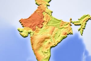
- Himalayas: Youngest and highest mountain range, home to peaks like Mount Everest; separates India from Tibet.
- Western and Eastern Ghats: Mountain ranges along the western and eastern coasts; rich biodiversity and unique ecosystems.
-
Plains:
- Indo-Gangetic Plain: Fertile alluvial plains formed by the Ganges, Indus, and Brahmaputra rivers; crucial for agriculture.
-
Plateaus:
- Deccan Plateau: Large plateau in southern India; consists of volcanic rock and is bordered by the Western and Eastern Ghats.
-
Deserts:
- Thar Desert: Located in northwestern India; characterized by arid climate, sparse vegetation, and sand dunes.
-
Rivers:
- Ganges: Sacred river; vital for agriculture and cultural practices.
- Indus: Major river in northern India and Pakistan; historically significant for ancient civilizations.
- Brahmaputra: Flows through northeastern India, known for its strong currents and floodplains.
-
Coastal Areas:
- Western Coast: Features sandy beaches and backwaters; economically important for fishing and tourism.
- Eastern Coast: Known for its deltas formed by the Mahanadi, Godavari, and Krishna rivers.
-
Islands:
- Andaman and Nicobar Islands: Group of islands in the Bay of Bengal; diverse flora and fauna, strategic location.
-
Climate Zones:
- Tropical Monsoon: Predominant in most of India; characterized by seasonal monsoons influencing agriculture.
- Arid and Semi-arid: Found in the northwest, affecting vegetation and land use.
-
Biodiversity: India is one of the 17 megadiverse countries; hosts various ecosystems and endangered species (e.g., Bengal tiger, Indian rhinoceros).
Physical Geography
- Focuses on Earth's natural spatial patterns and processes.
- Key elements include landforms, climate, vegetation, soil, and water bodies.
Key Components
- Landforms: Includes various types such as mountains, valleys, plains, plateaus, and hills.
- Climate: Defined by temperature, precipitation, and wind patterns; affected by latitude, altitude, and proximity to large bodies of water.
- Vegetation: Diverse ecosystems reflect varying climates and soil types, encompassing forests, grasslands, and deserts.
- Soil: Different types and formations impact agriculture and the distribution of vegetation.
- Water Bodies: Major rivers, lakes, and oceans shape landforms and influence local climates.
Physical Features of India
-
Mountain Ranges:
- Himalayas: The highest mountain range, includes Mount Everest; acts as a natural barrier between India and Tibet.
- Western and Eastern Ghats: Coastal ranges rich in biodiversity, fostering unique ecosystems.
-
Plains:
- Indo-Gangetic Plain: Fertile alluvial plains from Ganges, Indus, and Brahmaputra rivers; essential for India's agriculture.
-
Plateaus:
- Deccan Plateau: Dominant plateau in southern India characterized by volcanic rock, flanked by the Western and Eastern Ghats.
-
Deserts:
- Thar Desert: Located in northwestern India, features arid conditions, limited vegetation, and extensive sand dunes.
-
Rivers:
- Ganges: Revered sacred river playing a crucial role in agriculture and cultural traditions.
- Indus: A major river flowing through northern India and Pakistan, vital to ancient civilization development.
- Brahmaputra: Flows through northeastern India, recognized for its powerful currents and floodplain areas.
-
Coastal Areas:
- Western Coast: Notable for beaches and backwaters; economically important for fishing and tourism.
- Eastern Coast: Known for river deltas created by Mahanadi, Godavari, and Krishna rivers.
-
Islands:
- Andaman and Nicobar Islands: Located in the Bay of Bengal, these islands offer rich biodiversity and a strategic position.
-
Climate Zones:
- Tropical Monsoon: Dominates most of India, with seasonal monsoons that are critical for agricultural cycles.
- Arid and Semi-arid Regions: Found in the northwest, these areas influence local vegetation and land use patterns.
-
Biodiversity: India is recognized as one of the 17 megadiverse countries, hosting a variety of ecosystems and numerous endangered species, including the Bengal tiger and Indian rhinoceros.
Studying That Suits You
Use AI to generate personalized quizzes and flashcards to suit your learning preferences.
Description
Delve into the key components of physical geography, focusing on landforms, climate, vegetation, soil, and water bodies. Additionally, explore the significant physical features of India, including the majestic Himalayas and the rich biodiversity of the Ghats. This quiz will test your understanding of how these elements shape our world.


