Podcast
Questions and Answers
What is the primary composition of the Himalayas?
What is the primary composition of the Himalayas?
- Igneous rocks
- Sedimentary rocks (correct)
- Metamorphic rocks
- Volcanic rocks
Which of the following ranges is found in the Lesser Himalayas?
Which of the following ranges is found in the Lesser Himalayas?
- Zanskar
- Siachen
- Karakoram
- Pir Panjal (correct)
What is the average height of the outer Himalayas?
What is the average height of the outer Himalayas?
- 1000 meters
- 2000 meters
- 1500 meters
- 900-1200 meters (correct)
What climatic feature affects the snowline in the Himalayas?
What climatic feature affects the snowline in the Himalayas?
Which mountain range is the connecting link between the Himalayas and Central Asia?
Which mountain range is the connecting link between the Himalayas and Central Asia?
Which coast of India supports over 75% of its fish catch?
Which coast of India supports over 75% of its fish catch?
Which of the following correctly describes the shape of the Himalayas?
Which of the following correctly describes the shape of the Himalayas?
What is the approximate length of the Himalayan mountain range?
What is the approximate length of the Himalayan mountain range?
Flashcards
Lesser Himalayas
Lesser Himalayas
Mountain range averaging 1000 meters in height, includes Pir Panjal and Nainital.
Eastern Himalayas
Eastern Himalayas
Region including Patkai Hills, Naga Hills, and extends along India-Myanmar boundary.
Himalayas
Himalayas
Youngest fold mountain ranges in India, meaning 'Abode of Snow'.
Outer Himalayas
Outer Himalayas
Signup and view all the flashcards
Pamir
Pamir
Signup and view all the flashcards
Snowline
Snowline
Signup and view all the flashcards
Malabar Coast
Malabar Coast
Signup and view all the flashcards
Coromandel Coast
Coromandel Coast
Signup and view all the flashcards
Study Notes
Geography of India
- India's west coast, the Malabar coast, has a wider continental shelf, supporting over 75% of its fish catch.
- The east coast, or Coromandel coast, has a narrower shelf with a lower fish catch compared to the west.
- Sir Creek is a 96 km long estuary where the Arabian Sea meets the Rann of Kutch.
Physiography of India
- Physiographically, India is divided into: mountains (north), plains (northern India and coast), plateau (south), and coasts and islands.
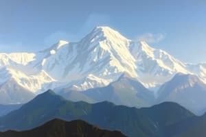
- The Himalayas, meaning "Abode of Snow," are the youngest fold mountains, highly unstable, and primarily made of sedimentary rocks.
- The Himalayas stretch from the Indus River in the west to the Brahmaputra River in the east, varying from 500 km in Kashmir to 200 km in Arunachal Pradesh.
- The Himalayas have an average height of 2000 m and a convex arc shape, curving southward, due to northward drift.
- The Eastern Himalayas are also known as Purvanchal, branching south beyond the Dihang River.
Mountain Ranges
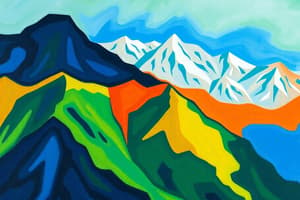
- The Himalayas are further divided into the Great Himalayas, Lesser Himalayas, and the Outer Himalayas (also called the foothills).
- The Great Himalayas include the highest peaks, while the lesser Himalayas have lower ranges.
- The Outer Himalayas are the foothills, with elevations between 900 and 1200 m.
Additional Information
- The Pamir is the connecting link between the Himalayas and the high ranges of Central Asia, and the snowline is lower in the west Himalayas than the east.
- The snowline in the Himalayas is at 28°N in some places (lower altitude) and 36°N in others (warmer temperatures).
- The Himalayas are divided into three parallel zones, each with distinct features.
Important Peaks & Locations
- Mount Everest (Sagarmatha or Chomolungma) in the Himalayas is the highest peak.
- Other significant peaks include: Mt. Kanchenjunga, Mt. Lhotse, Mt. Makalu, Mt. Dhaulagiri, Mt. Cho Oyu, Mt. Nanga Parbat, Mt. Annapurna, Mt. Nanda Devi.
Studying That Suits You
Use AI to generate personalized quizzes and flashcards to suit your learning preferences.