Podcast
Questions and Answers
How are rivers in India primarily classified?
How are rivers in India primarily classified?
- According to their length
- According to their volume of water
- According to their depth
- According to their source region (correct)
Which ocean does the River Puraguaco enter?
Which ocean does the River Puraguaco enter?
- Arctic Ocean
- Atlantic Ocean (correct)
- Pacific Ocean
- Indian Ocean
Which characteristic best describes the rivers originating in the Himalayas?
Which characteristic best describes the rivers originating in the Himalayas?
- They dry up in summer
- They are intermittent rivers
- They originate from lakes
- They are perennial rivers (correct)
What is a significant characteristic of Himalayan rivers in the summer?
What is a significant characteristic of Himalayan rivers in the summer?
Which river systems are major components of the Himalayan drainage?
Which river systems are major components of the Himalayan drainage?
Which river is not a part of the major river systems of the Himalayan drainage?
Which river is not a part of the major river systems of the Himalayan drainage?
Which of the following lakes is located within the Himalayan region?
Which of the following lakes is located within the Himalayan region?
What geographical feature is the primary source of most major rivers in the Himalayas?
What geographical feature is the primary source of most major rivers in the Himalayas?
During which season do Himalayan rivers experience flooding?
During which season do Himalayan rivers experience flooding?
Which of the following rivers is not part of the Indus river system?
Which of the following rivers is not part of the Indus river system?
Flashcards are hidden until you start studying
Study Notes
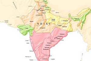
Geographical Explanation of India
- India can be divided into five major physiographic divisions:
- The Himalayas
- The North Indian Plains
- The Peninsula
- Coastal Plains
- Island Groups
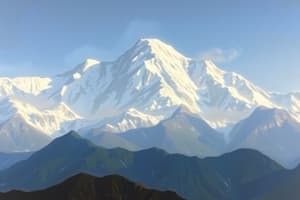
The Himalayas
- The Himalayas are young fold mountains that extend from the Pamir Knot in Tajikistan to the East
- In India, they extend from Jammu and Kashmir to Arunachal Pradesh
- The Himalayas are not a single mountain range, but multiple parallel ranges including:
- Siwaliks (the southernmost and youngest)
- Lesser Himalayas
- Greater Himalayas (Himadri)
- Trans Himalayan ranges
- The mountain ranges are also divided into:
- Western Himalayas (or Kashmir Himalayas)
- Central Himalayas (or Kumaun Himalayas)
- Eastern Himalayas (or Assam Himalayas)
North Indian Plains
- The North Indian Plains lie between the Himalaya Mountains in the north and the Peninsula in the south
- They extend from Rajasthan and Punjab in the west to Assam in the east
- The plain is mostly a flat, low-lying area
- It is divided into two parts:
- The part lying to the east of the Aravalis is the basin of the river Ganga and is known as the Ganga Plains
- It slopes eastward and includes the delta of Ganga-Brahmaputra system, known as Sunderbans, which is the world’s largest delta
The Peninsula
- The area lying to the south of North Indian plains and tapering towards the Indian Ocean is called the Indian Peninsula
- It consists of many plateaus and hill ranges
- The Aravalis in the north are the oldest fold mountains in the region
- It includes a series of plateaus bordering the plains, Vindhyas and Satpura ranges in the central part, and the hilly regions of Western and Eastern Ghats
Coastal Plains (India)
- The Coastal Plains lie to the western side of the Peninsula
- It is a long coastline extending for 7500 km
- The western coastline shows remarkable dissection
- The western coast borders the Arabian Sea and is a rocky coast
- Spurs taking off from the Western Ghats are extended right up to the coast
- Rivers originating from the Western Ghats are short and swift, so their mouths are less defined and are not deltas
- The eastern coast borders West Bengal and has formed as a result of the work of rivers
- Many east-flowing rivers from the Western and Eastern Ghats coast flow at lower velocities, and sediments brought with them at the lower end result in deltas found along this coast
The Island Group
- India has many small and large islands along the mainland
- These are included in the Indian Island group
- Besides, India has two groups of islands, one each in the Arabian Sea and Bay of Bengal
- The islands in the Arabian Sea are known as Lakshadweep, and those in the Bay of Bengal are called the Andaman and Nicobar Islands
- Most of the islands in Lakshadweep are coral islands of atoll shape and small in extent
Geographical Explanation of Brazil
- Brazil can be divided into several physiographic divisions:
- The Highlands
- The Coastal region
- The Island groups
- The Great Escarpment
- The Plains
The Highlands
- The southern Brazil is occupied by an extensive plateau, known as the Brazilian Highlands or Brazilian Shield or Brazilian Plateau
- It covers the states of Roraima, Para, and Amapa in the north
- The lower part of these highlands is found in Brazil, with an altitude of more than 1000m
- The highest peak of Brazil, Pico de Neblina, is 3014m high and lies on the border between Brazil and Venezuela
The Great Escarpment
- Occurs in a small area but greatly impacts the climate
- Its height is 790m
- Steep from Sao Paulo to Porto Alegre
- Acts as a barrier to Southeast Trade Winds, creating a rain shadow area in the northeast
The Coasts
- Brazil has a coastline of 7400 km
- Divided into Northern and Eastern Coasts
- The Northern Coast extends from Amapa to Rio Grande do Norte, also known as the North Atlantic Coast
- The Eastern Coast extends from the North towards the South
- The Northern Coast is characterized by river mouths, including the Amazon, making it a low-lying region
- The Eastern Coast receives many smaller rivers, with the only major river being the Amazon
The Plains
- Confined to two areas: the Amazon Basin in the north and Paraguay-Parana source region in the southwest
- The Amazon Plains form the largest plain in Brazil, sloping eastwards
- The Paraguay-Parana source region is located in southwestern Brazil
- The source region of Paraguay slopes south, and the source region of Parana slopes southwest
Pantanal
- One of the largest wetlands in the world
- Located in southwestern Mato Grosso do Sul
- Extends into Argentina
- Consists of swamps and marshes
Islands
- Divided into Coastal and Marine Islands
- Coastal islands are formed by deposition, while Marine islands were part of the mainland
- Marine Islands are 300km away from the mainland, are mostly rocky, and are the tops of submerged mountains
- Coral islands near the coast are called atolls
Studying That Suits You
Use AI to generate personalized quizzes and flashcards to suit your learning preferences.