Podcast
Questions and Answers
Which of the following best describes the location of Pakistan?
Which of the following best describes the location of Pakistan?
- Between 24 degrees north and 37 degrees north latitude (correct)
- Between 15 degrees north and 30 degrees north latitude
- Between 20 degrees north and 35 degrees north latitude
- Between 30 degrees north and 40 degrees north latitude
The Wakhan corridor is a strip of Afghan territory that separates Pakistan from India.
The Wakhan corridor is a strip of Afghan territory that separates Pakistan from India.
False (B)
What is the study and description of the surface features of land called?
What is the study and description of the surface features of land called?
topography
According to the Plate Tectonic Theory, the Earth's surface is made up of rigid plates of ______ that float on the asthenosphere.
According to the Plate Tectonic Theory, the Earth's surface is made up of rigid plates of ______ that float on the asthenosphere.
Match the following mountain ranges with their location in Pakistan:
Match the following mountain ranges with their location in Pakistan:
What is the average altitude range of the Karakoram Range?
What is the average altitude range of the Karakoram Range?
Transhumance, the seasonal movement of livestock, is not practiced in the Northern Mountains.
Transhumance, the seasonal movement of livestock, is not practiced in the Northern Mountains.
What type of forests are commonly found in the Safed Koh range?
What type of forests are commonly found in the Safed Koh range?
The ______ hills are located between the Kurram and Gomal Rivers.
The ______ hills are located between the Kurram and Gomal Rivers.
Match each river with the area it drains.
Match each river with the area it drains.
Which of the following is a common economic activity in the Balochistan Plateau?
Which of the following is a common economic activity in the Balochistan Plateau?
The Potwar Plateau is primarily composed of sedimentary deposits and lacks mineral resources.
The Potwar Plateau is primarily composed of sedimentary deposits and lacks mineral resources.
What are the plains formed by the River Indus and its tributaries commonly called?
What are the plains formed by the River Indus and its tributaries commonly called?
The land between two rivers is called a ______.
The land between two rivers is called a ______.
Match each 'Doab' with the rivers that define it:
Match each 'Doab' with the rivers that define it:
Piedmont plains are primarily
Piedmont plains are primarily
The Indus Delta is triangular or fan-shaped because it is formed by tectonic activity.
The Indus Delta is triangular or fan-shaped because it is formed by tectonic activity.
What term is used to describe limestone ridges with a gentle slope on one side and a steep slope on the other?
What term is used to describe limestone ridges with a gentle slope on one side and a steep slope on the other?
Rolling sand dunes, weathering of rocks, and sparse vegetation are main features of the ______ areas of Pakistan.
Rolling sand dunes, weathering of rocks, and sparse vegetation are main features of the ______ areas of Pakistan.
Match each desert in Pakistan with its defining features.
Match each desert in Pakistan with its defining features.
Which term describes a prolonged shortage of water?
Which term describes a prolonged shortage of water?
Renewable resources occur in limited quantities and cannot be replenished.
Renewable resources occur in limited quantities and cannot be replenished.
What term is used to describe the continuous circulation of water between the Earth's surface and the atmosphere?
What term is used to describe the continuous circulation of water between the Earth's surface and the atmosphere?
According to the Indus Waters Treaty, control over the three 'eastern' rivers was given to ______.
According to the Indus Waters Treaty, control over the three 'eastern' rivers was given to ______.
Match the dam to the river it is located on.
Match the dam to the river it is located on.
What is the underground structure for collecting groundwater and conveying it to the surface called?
What is the underground structure for collecting groundwater and conveying it to the surface called?
Sprinkler systems are inefficient and lead to high water wastage.
Sprinkler systems are inefficient and lead to high water wastage.
What is the deposition of river-transported materials into reservoirs called?
What is the deposition of river-transported materials into reservoirs called?
The canals which do not have concrete or cemented embankments are called ______ canals.
The canals which do not have concrete or cemented embankments are called ______ canals.
Match the terms with their definitions.
Match the terms with their definitions.
What is the purpose of planting Eucalyptus trees in waterlogged areas?
What is the purpose of planting Eucalyptus trees in waterlogged areas?
In Pakistan, about 25% of the total area is covered with forest.
In Pakistan, about 25% of the total area is covered with forest.
What is the main function of protective forests?
What is the main function of protective forests?
Areas such as Gilgit, Skardu, and Chitral are regions where ______ forests are commonly found.
Areas such as Gilgit, Skardu, and Chitral are regions where ______ forests are commonly found.
Match the type of forest with its characteristics:
Match the type of forest with its characteristics:
What is the practice of removing trees on a large scale called?
What is the practice of removing trees on a large scale called?
The fishing industry has a share of 5% in Pakistan's GDP.
The fishing industry has a share of 5% in Pakistan's GDP.
Which Pakistani city is the main fishing center on the Sindh coast?
Which Pakistani city is the main fishing center on the Sindh coast?
In subsistence fishing, the fisherman and his family ______ the fish they catch.
In subsistence fishing, the fisherman and his family ______ the fish they catch.
Match the type of fish with the body of water they are from
Match the type of fish with the body of water they are from
What is the per capita fish consumption in Pakistan compared to European countries?
What is the per capita fish consumption in Pakistan compared to European countries?
Mining is exclusively carried out in mountainous regions.
Mining is exclusively carried out in mountainous regions.
Flashcards
What is topography?
What is topography?
Study and description of surface features of land.
Name one of the major natural topography areas of Pakistan
Name one of the major natural topography areas of Pakistan
The Northern Mountains and North-western Mountains (Himalayas, Hindukush, the Karakorum).
What is the Plate Tectonic Theory?
What is the Plate Tectonic Theory?
Theory that the Earth's surface is made of rigid plates floating on the asthenosphere.
What are the key features of Karakoram Range/Himalaya/Hindukush Relief?
What are the key features of Karakoram Range/Himalaya/Hindukush Relief?
Signup and view all the flashcards
What is Drainage?
What is Drainage?
Signup and view all the flashcards
What is the importance of Northern Mountains?
What is the importance of Northern Mountains?
Signup and view all the flashcards
Why are they are called Safed Koh (White Mountains)?
Why are they are called Safed Koh (White Mountains)?
Signup and view all the flashcards
What is located Waziristan hills?
What is located Waziristan hills?
Signup and view all the flashcards
What is the lifestyle in the western mountains?
What is the lifestyle in the western mountains?
Signup and view all the flashcards
What is present in Baluchistan Plateau?
What is present in Baluchistan Plateau?
Signup and view all the flashcards
What extracted form Baluchistan plateau
What extracted form Baluchistan plateau
Signup and view all the flashcards
Where is Potwar Plateau & Salt Range?
Where is Potwar Plateau & Salt Range?
Signup and view all the flashcards
What are active Flood Plain areas?
What are active Flood Plain areas?
Signup and view all the flashcards
What are Alluvial Terraces?
What are Alluvial Terraces?
Signup and view all the flashcards
What are Inundation Canals /seasonal canals?
What are Inundation Canals /seasonal canals?
Signup and view all the flashcards
What is Water logging?
What is Water logging?
Signup and view all the flashcards
What is (SCARP) programme.
What is (SCARP) programme.
Signup and view all the flashcards
What called Forest?
What called Forest?
Signup and view all the flashcards
What are Productive Forests?
What are Productive Forests?
Signup and view all the flashcards
What are Protective forest?
What are Protective forest?
Signup and view all the flashcards
What is located at Alpine forests?
What is located at Alpine forests?
Signup and view all the flashcards
Coniferous?
Coniferous?
Signup and view all the flashcards
What is Deforestation?
What is Deforestation?
Signup and view all the flashcards
What is Sustainable forestry?
What is Sustainable forestry?
Signup and view all the flashcards
What called Fishing?
What called Fishing?
Signup and view all the flashcards
What is called Commercial fishing?
What is called Commercial fishing?
Signup and view all the flashcards
How much GDP Fishing sector occupies?
How much GDP Fishing sector occupies?
Signup and view all the flashcards
What are Adit?
What are Adit?
Signup and view all the flashcards
what is the uses of Rock Salt?
what is the uses of Rock Salt?
Signup and view all the flashcards
is Coal used by Pakistan having low quality?
is Coal used by Pakistan having low quality?
Signup and view all the flashcards
Thermal electricty is which type of use?
Thermal electricty is which type of use?
Signup and view all the flashcards
what fuel is non renewable in non renewable energy resources?
what fuel is non renewable in non renewable energy resources?
Signup and view all the flashcards
what is mineral oil?
what is mineral oil?
Signup and view all the flashcards
Study Notes
Geography of Pakistan
- Pakistan is located between 24°N and 37°N latitude and extends from 61°E to 78°E longitude.
- It shares a border with China to the northeast, Afghanistan to the west (Durand Line), Tajikistan to the northwest via the Wakhan Corridor, Iran to the southwest, and India to the east.
- The Arabian Sea lies to its south.
- Pakistan has five provinces: Punjab, Sindh, Khyber Pakhtunkhwa (KPK), Gilgit Baltistan, and Balochistan.
- There is one federal capital territory, two autonomous and disputed territories, and a group of Federally Administered Tribal Areas.
- The government has three lower tiers, including 34 divisions, 149 districts, 588 sub-districts, and several thousand union councils.
Pakistan's Natural Topography
- Topography analyzes land surface features.
- Pakistan is divided into six major natural topographic areas:
- Northern and northwestern mountains (Himalayas, Hindukush, Karakoram)
- Western mountains (Safed Koh ranges, Waziristan hills, Suleiman range, Kirthar range)
- Balochistan plateau
- Potwar plateau and Salt Ranges
- Indus plain
- Desert areas (Kharan, Thar, Thal)
Plate Tectonic Theory
- Tectonics originates from the Greek term 'Tekton' meaning builder.
- The earth's surface comprises rigid lithosphere plates floating on the mobile asthenosphere.
- Plate movement causes continent drifting, mountain building, earthquakes, and volcanic activity, predominantly at plate edges.
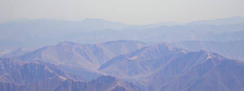
Karakoram Range/Himalaya/Hindukush Relief
- Average altitude: 3000-6000m.
- Composed of rock and ice with a rugged landscape.
- Features include snow-covered peaks, valleys, gorges, cliffs, ravines, and gullies.
- Steep-sided peaks and narrow valleys exist.
- Cold winds occur during winter while summers are mild.
- Precipitation is mainly snowfall at higher altitudes and rainfall at lower altitudes.
- Alpine forests are present with Glaciers.
- Khunjerab and Karakoram passes are in the Karakoram Range.
- Khyber, Lawari, and Shandur passes are in Himalaya.
Drainage of the Karakoram Range
- Drainage involves the total runoff of water.
- The Shyok and Gilgit rivers are the main drainage sources.
- Glacial melt contributes to the water table.
- Rivers in the upper course flow rapidly.
- Rivers carry pebbles and stones, depositing silt in reservoirs.
- River Indus and River Chenab are the main sources of drainage in the Himalayas.
- River Swat and river Kabul are the main sources of drainage at Hindukush.
- The Warsak Dam irrigates and generates power on the Kabul River.
Life Style and Economic Activities in Northern Mountains
- Nomadic to semi-nomadic lifestyles prevails at higher altitudes.
- Animal rearing is a primary occupation, where transhumance is practiced.
- Agriculture is performed on a smaller scale.
- The Warsak Dam provides irrigation, drainage, and power.
- Mining is present, along with primary, secondary, and tertiary industries.
- Apple, apricot, grapes, and peaches are abundant agricultural products.
Importance of the Northern Mountains
- Historical passes link Pakistan to China and Afghanistan.
- The Karakoram Highway facilitates trade, and snowcapped peaks melt in summer to feed Indus tributaries, irrigating the Indus Plain.
- They are a source of minerals, timber, and fruits, providing raw materials for diverse industries.
- Mountains protect against cold Central Asian winds, maintaining tolerable climate conditions.
- Scenic beauty boosts tourism, generating income for local communities.
Important Passes of the Northern Mountains
- The Karakoram Pass (5575m) connects Kashmir with China. Hunjarab pass connects Northern Areas with China.
- The Lawari Pass (3188m) links Dir and Chitral.
- Babusar (Himalayas) at 4173m links Northern Areas and Mansehra.
- Khyber Pass leads to the Peshawar valley.
- Kurram Pass is a land route to Afghanistan.
- Tochi Pass connects Gazhni to Bannu.
- Gomal Pass connects Afghanistan to Derajats.
- Bolan connects the Kachhi Sbi Plain to Quetta.
Western Mountains
Safed Koh:
- Located south of the Kabul River, peaks are often snow-covered, giving it the name "White Mountains".
- Steep mountains and deep valleys are identifiable characteristics.
- Reaching heights of 4712 meters, snowfall occurs at higher altitudes and rainfall at lower altitudes during winters.
- Winters are cold while summers are mild.
- The Kurram Pass enables routes to Afghanistan.
- Peshawar and Kohat are cities within the area.
- Features include Alpine and coniferous forests. Waziristan Hills
- Located between the Kurram and Gomal Rivers, which reaches 3513 meters.
- Hill ranges form a border between Afghanistan and Pakistan
- The Tochi and Gomal passes can be located there Sulaiman Range
- Located west of the Indus River.
- Its highest peak, Takht-e-Sulaiman, reaches 3500 meters.
- The Kirthar Range joins the southern part of the Sulaiman Range which is backed later on by the Pab Range.
- Drainage includes River Kabul & Kurram, and melting snow feeds the water table. Rivers
- upper courses lead to fast flows, while the Arabian Sea marks the southern border.
- Kurram Dam aids in irrigation and power at Safed Koh.
- Limestone and sandstone are the main minerals.
- Rivers Hub, Porali, and Hingoli drain the range.
- Braided channels characterize drainage of the range.
- Hub dam aids irrigation, drainage, and power generation. Life Style & Economic Activities
- Barren vegetation, climate, and relief limit farming, yet canal irrigation and nomadic, semi-nomadic lifestyles exist.
- Limited transport save for Peshawar and Kohat, infrastructure costs are high, and animal rearing prevails.
- Mineral resources abound, and house cottage industries thrive in winter.
Balochistan Plateau
- Located in southwest Pakistan; altitudes range from 600-3010 meters, covering 347190 sq km.
- Features: basins, mountain ranges (Toba Kakar, Central Brahvi, Chaghai, Ras Koh, Makran, Siahen), and coastal areas.
- Nomadic and semi-nomadic lifestyles are common, with animal rearing and agriculture limited.
- Irrigation depends on canals linked to dams and barrages.
- Mineral-rich: natural gas, coal, limestone, copper, and post-extraction, fishing and marine activities along coastal areas. Mangrove forests are the primary vegetation.
Potwar Plateau & Salt Range
- South of Islamabad, between the Indus and Jhelum rivers, featuring badland topography, heights from 300-600m
- Dominant with limestone ridges, salt, coal, oil mines, ravines, salt lakes (Kalar Kahar, Khabaki) and hill ranges (Kala Chitta, Khairi Murat).
- The Jhelum and Soan rivers act as main drainage sources, and the Mangla Dam is a source for irrigation, drainage, and power.
- Mineralized with coal, rock salt, and limestone used to be abundant
- Limited agriculture, it houses the Attock Oil refinery, high-density population, and all industry types.
- Developed and connected via roadways, rail, and airways.
Indus Plain
- Formed by the deposition of sediment by the Indus River and its tributaries.
- Spans most of Punjab and central Sindh, with the northern segment called the upper Indus plain.
- River Panjnad joins five Indus tributaries, flowing 72 km, joining the Indus near Mithankot.
- Lower Indus plain: below Mithankot in Sindh till the Arabian Sea.
- Active Flood Plain areas:
- Strips on both sides of the river, known as Bet or Khaddar land, have fertile soil from annual alluvium deposits.
- The plains are annually inundated and are important farming areas with meanders, oxbow lakes, and levees are common features.
- Old Flood Plain Areas:
- Elevated, formed by old alluvium deposits, and once a decade or so can be inundated.
Other Features in the Indus Plain
- Alluvial Terraces (Bars): Locally called Bars that are land between two rivers (doab): Sindh-Sagar, Chaj, Rachna, Bari.
- Piedmont Plains: At the base of the Suleiman, Kirthar, and Himalayan Mountains. Alluvial fans dominate these agricultural plains.
- Tidal Delta: South of Thatta, triangular/fan-shaped, and has alluvium deposits.
- Mangrove swamps are present with generally a flat and low landscape.
- Cuestas: Limestone ridges with a dip on one side and steep slope/scarp on the other.
- Serve as a base for barrages and scenic beauty.
Desert Areas
- Desert regions are located at of three places.
- (i) Thal Desert: Situated between the Indus and Jhelum. -(ii) Thar Desert: Lies in southeastern Pakistan- Cholistan, Nara, and Tharparkar
- (iii) Kharan desert: Rolling sand dunes, bare rocks, negligible vegetation, scanty rainfall, and a very low water table are general features.
Important Terms
- Avalanche: A large mass of snow moves down a slope.
- Bar: An alluvial terrace is an old flood plain.
- Bet: active flood plain.
- Doab/Interfluves: Land between two rivers.
- Dhand: a small salt lake.
- Khaddar: Fresh Alluvium.
- Karez is an irrigation method used in Baluchistan; it's a water tunnel.
- Landslide is the displacement of rocks and soil on mountain slopes.
- Mountain: An elevated section of the earth with a peak, steep slope obtaining a height of over 1000 meters than a hill.
- Range: A collection of mountains.
- Plateau: A region of level of high ground.
- Plain: Flat soil used to grow crops.
- Topography: Configuration of the features by area.
- Relief: Particular forms of a physical.
- Economic activity: undertaking activities to produce.
Climate of Pakistan
- Weather: day-to-day atmospheric changes.
- Climate: atmosphere conditions persisting for a prolonged (30 year) period.
Three climate element Temperature- Large altitude difference from 24°N to 37°N Atmospheric Pressure Precipitation (rainfall Humidity Winds
- Main sources of Rainfall Rainfall through Monsoon winds (July -September) Rainfall through the western depression (November -March) Rainfall through the thunderstorm (October -November, April -June) Relief Rainfall Tropical cyclones
Rainfall via Monsoon Winds
- Monsoon means season, originating from the Bay of Bengal in the Indian Ocean, moving from east to west.
- Winds cause rainfall above Bangladesh and India, utilizing the winds by the time it gets to Pakistan.
Rainfall via Western Depression
- Winds cause the rain during the winter-originating above the Mediterranean Sea and heading to eastern lands.
- Winds causes rainfall above Turkey; parts of the Middle East; Iraq; and Afghanistan.
- Little rain occurs as most of the moistures to be utilized.
- Snow and light rain can occur during the winter at lower and higher elevation levels due to western winds during the winter-and Murree, Swat, and Gilgit can be a few of those sections.
Convectional Rainfall Through Thunderstorm
- Experienced due to evaporated wind.
- Local transpiration causes water molecules to go into the atmosphere and then condense into clouds to create precipitation above the areas.
Relief Rainfall
- Mainly confined towards northern mountainous areas.
- Windward side of mountains get the rain than leeward side.
Causes for Floods
- Melting of snow during winter;
- Heavy rain from monsoon time period
- The action of cutting of trees along the plains increases the surface of runoff or stream from runoff.
- Inability of certain levels to strengthen levels above the ground along banks.
Causes for drought
- In Pakistan, prolonged shortage of supply of water for drought and rainfall leads to severe shortage and damages crops.
- Droughts also cause illness, hunger, and death on a large grade
- Causes are from unstable winds, earth's climate level, and deforestation- along with mismanagement.
UNIT 3 WATER RESOURCES
-
Natural resources can be described as renewable or nonrenewable resources.
-
Renewable resources:
- RR can be recycled or reused.
-
Nonrenewable resources:
- NRS occur in limited quantity.
Hydrological cycle:
- The water that reaches the ground from the atmosphere falls in various ways such as rain, snow or hail. This is called precipitation.
- Some of the water runs directly off the earth's surface as rivers and streams draining into lakes and the sea.
- The rest of the water is either utilized by plants or soaks into the ground.
- Water is returned to the atmosphere as water vapor through evaporation from surface water and by transpiration from plants.
- Rising into the atmosphere the water vapor cools to form water droplets and this system is called condensation.
- This cycle is called the hydrological cycle.
The Indus system:
- Indus is the largest river of Pakistan
- It is watered by the glaciers of the Karakorum and Hindu Kush. The source of river Indus is at the lake Mansorowar at Tibet China.
- After crossing the Himalayas it turns into south west and enters Pakistan.
- After leaving the mountainous region of kalabagh the river enters the plains of Punjab and Sindh.
- Finally the Indus flows into Arabian Sea.
- The total journey of the Indus from source to mouth is about2900 km.
- On its way from source to mouth Indus is joined by some Eastern and Western tributaries.
Plate Tectonic Theory:
- Tectonic' comes from the Greek word 'Tekton', meaning builder.
- The Earth's surface is made up of rigid lithosphere plates.
- Theory explains processes such as continent drifting, mountain-building, earthquakes and volcanic activities.
Water distribution treaty between India and Pakistan
- The treaty was signed in Karachi in September 1960.
- Control over the three "eastern" rivers was given to India and 'western' rivers were given to Pakistan.
- dam is also available in Pakistan.
Types of irrigation
- Shaduf-A more heavier style of weight. - A certain ordinary type of is for about 3-5 meters down, while deeper wells do have about 15 meters.
- Inundated canals- The lengthy and vast range of areas for rivers, for large range of areas.
- Certain areas can be irrigated and lots of waste-age can also be reduced.
Methods To Transport
- Transportation is reduced and very minimal.
- Wells can lift the ground above the certain levels with irrigation and salinity
- The waterways and shipping waterways are also being a lot more convenient.
Climate types in general.
- Rainfall is through Monsoon weather (from July to September)
- The rainfall the areas get is really small or variable as well.
- As for main rainfall is at the area of 125 min
Water usage information
- 95 percent is the total number when being applied for irrigational purposes
- The different industrial and other waterways also have certain requirements.
- Canal system can have irrigational and very huge quantities can be given.
Types of Canals:
- Inundation Canals/Water irrigation is only for a certain period.
Other types of rain or rainfall:
- The constant of rain or rainfall does also occur in the northern mountain region. - Excess water to be evaporated occurs above or above each atmospheric amount.
Tidal power information or usage:
- The tidal are is based around south to thatta - A delta are where liquid pours or is to be ejected.
Underground:
Rolling dunes with not vegetation means the weather is more terrible.
Dams: -Dams are very supportive due to what the world provides above those certain levels.
Other information about the canals:
- A reduction for certain level of power can be reduced or have reduced function.
- Many scale of deforestation and more forest region can be increased. -Certain type of embankments of water can occur for a higher amount needed.
Canals:
- Those with concrete or cement.
Water logging info about the surface:
The water table happens to occur more often when level does increase more greatly, causing more issues and problems.
Types of crops
- Wheat grows with a lot of baked goods.- Wheat is highly more used from the Canal region of Sindh and Punjab to meet the crops needs.
- The amount harvest was done by each person for harvest. - Many new crops are also now grown- along with rice and export too are on an increase.
- Exports like fruits- rice, and others are becoming a higher priority due to what the export needs are. Different types of food or grains are now being utilized in the production with the help to those to make or have the process of making edibles from what can be in Pakistan
Irregular supplies of water:
- The rain is or becomes more difficult during those seasons. - A certain irregular system of what more of the problems can be dealt with is known as or are.silt - Where some can cause blockage to irrigation due to silt,
Underground: The better for to have the source that has better output then the normal.
Different level of resources: Like the certain energy needed to survive is better and of needed requirement for survival
Underground Mining: The better and or more in height for better sources.
Many types of ores and such do come from some rock.
Nonmetallic or Metallic with Minerals: There to be high sources known for a certain degree or form of possession.
Metallic/Minerals info: Copper has more electricals than others
Main types of industrial areas: Textile
Mining processes: To digging and dig up
Resources Of Pakistan -
Coal - is from vegetative matter- Transport from railway coal to industrial. - Is being used from industrial work and industrial fuel
Minerals important and valuable-
Copper- for the uses of - Electrical wires- Other electrical- Alloys Bauxite-is good for building and utensil/ tinn and cand
Hydo Power-is useful as a type for running the turbines.
Wind Turbines- Can run with a certain type of meter or speed. Geography in short -...by USMAN HAMEED
Studying That Suits You
Use AI to generate personalized quizzes and flashcards to suit your learning preferences.


