Podcast
Questions and Answers
What is the term for the lines that run east and west on a map?
What is the term for the lines that run east and west on a map?
- Meridians
- Equators
- Parallels (correct)
- Latitudes (correct)
Which of the following accurately describes the measurement of latitude?
Which of the following accurately describes the measurement of latitude?
- Marked solely within the Southern Hemisphere
- Measured in degrees east and west of the prime meridian
- Measured in degrees north and south of the equator (correct)
- Defined as lines parallel to the prime meridian
What is the reference point labeled as 0° for latitude?
What is the reference point labeled as 0° for latitude?
- Equator (correct)
- Tropic of Cancer
- North Pole
- Prime meridian
Which of the following is true about lines of longitude?
Which of the following is true about lines of longitude?
What is the significance of the prime meridian in geography?
What is the significance of the prime meridian in geography?
What is a landform region characterized by?
What is a landform region characterized by?
Why is it easier to compare and contrast different parts of the country using landform regions?
Why is it easier to compare and contrast different parts of the country using landform regions?
What aspect of climate is mentioned concerning its long-term effects?
What aspect of climate is mentioned concerning its long-term effects?
What might Stevenson have learned about during his trip across the United States?
What might Stevenson have learned about during his trip across the United States?
Which of the following is NOT a type of landform mentioned?
Which of the following is NOT a type of landform mentioned?
Which country in North America has the largest area?
Which country in North America has the largest area?
What is the population comparison between Mexico and Canada?
What is the population comparison between Mexico and Canada?
Where do most Canadians reside in relation to the country's geography?
Where do most Canadians reside in relation to the country's geography?
Which of the following statements about North America's largest countries is correct?
Which of the following statements about North America's largest countries is correct?
What aspect of Mexico's demographics is true when compared to Canada?
What aspect of Mexico's demographics is true when compared to Canada?
Flashcards are hidden until you start studying
Study Notes
Critical Thinking and Map Skills
- Relative location of five U.S. regions can be described in relation to each other and geographical features.
- Maps and globes utilize a grid system of imaginary lines for locating places.
- Lines of latitude (parallels) run east to west, measured in degrees north and south of the equator (0°).
- Lines of longitude (meridians) run north to south, measured in degrees east and west of the prime meridian (0°).
Landform Regions and Settlement Patterns
- Diverse landforms and climates throughout the U.S. influence settlement and land use.
- Rich soil and fresh water attract settlers; historically significant for Native Americans who began farming 5,000 years ago.
- Communities typically established near transportation routes like rivers, facilitating movement and trade.
Natural Resources and Land Use
- U.S. identified as rich in natural resources, which include soil, water, and minerals.
- Mining predominantly occurs in mountain regions where minerals are available.
- Urban areas mainly utilized for housing, transportation, and businesses; farming concentrated in coastal plains, interior plains, and fertile valleys.
- Land use practices often vary based on proximity to urban centers, with significant agricultural activities in rural areas.
Climate Regions Affecting Settlement
- Different climate regions encourage or discourage settlement based on availability of resources and land productivity.
- Types of climates include:
- Tropical wet (hot and rainy all year)
- Mediterranean (hot dry summers, mild rainy winters)
- Desert (dry, extreme temperatures)
- Humid subtropical (hot rainy summers, mild winters)
- Continental (hot summers, cold winters)
Conclusion
- Understanding geography through maps and globes is essential for exploring regional differences in settlement, land usage, and resource distribution in the United States.
Geography of North America
- The United States is located in North America, one of the seven largest continents.
- Canada, the U.S., and Mexico are the three largest countries in North America by area and population.
- Canada covers 3,855,100 square miles with a population of approximately 33 million.
- The United States spans 3,718,700 square miles, with a population of about 303 million.
- Mexico is smaller in area, at 761,600 square miles, but has a larger population of approximately 110 million.
Historical Context
- Canada and Mexico were both explored by the French and British, with a history of British rule in parts of Canada.
- Spain sent settlers to present-day Mexico and southwestern U.S. in the historical context.
Climate and Environment
- Climate is influenced by distance from the equator, ocean proximity, and elevation, affecting regional weather patterns.
- Regions closer to the equator, like Florida and Texas, are warmer than northern states like Michigan and Montana.
- Elevation affects climate; temperatures drop by roughly 3°F for every 1,000 feet increase in height.
Seasons in the Northern Hemisphere
- Four distinct seasons: Winter (Dec 21/22), Spring (Mar 20/21), Summer (Jun 21/22), Autumn (Sep 22/23).
- Seasonal changes arise from Earth's tilted axis as it orbits the sun, affecting sunlight distribution.
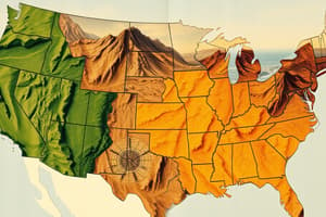
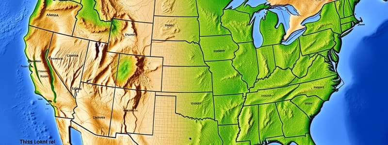
Landform Regions
- The U.S. is divided into various landform regions characterized by similar physical features such as mountains and plains.
- Each landform region has unique elements that facilitate comparison across different areas.
Human Impact on Environment
- Americans modify the land and waterways through actions like building dams, canals, and irrigation systems for agriculture.
- Dams create reservoirs for drinking water and electricity but can reduce downstream water flow.
- Irrigation allows farming in arid regions but can lead to negative environmental effects, including pollution.
- Human activities such as deforestation and mining significantly alter the environment for resource extraction.
Waterways and Urban Development
- Alteration of rivers and harbors to accommodate large ships by deepening channels illustrates human influence on natural waterways.
- The need for drinking water and electricity drives construction of wells and reservoirs.
Connection to Daily Life
- Climate impacts daily lifestyles, including clothing choices and seasonal activities, demonstrating the interaction between humans and their environment.
Studying That Suits You
Use AI to generate personalized quizzes and flashcards to suit your learning preferences.