Podcast
Questions and Answers
What do geographic coordinates use to describe positions on Earth?
What do geographic coordinates use to describe positions on Earth?
- Number values based on longitude, latitude, and elevation
- Number values based on latitude, longitude, and distance from the equator
- Number values based on longitude, latitude, and distance from the equator
- Number values based on latitude, longitude, and elevation (correct)
What is the Geographical Coordinate System (GCS) used for?
What is the Geographical Coordinate System (GCS) used for?
- Measuring distances between different points on the Earth's surface
- Measuring and communicating positions or locations on the Earth's surface (correct)
- Identifying the highest and lowest points on the Earth's surface
- Determining the area of a specific region on the Earth's surface
What is the main difference between the Geographical Coordinate System (GCS) and the Cartesian coordinate system?
What is the main difference between the Geographical Coordinate System (GCS) and the Cartesian coordinate system?
- GCS uses latitude, longitude, and elevation; Cartesian uses x-axis and y-axis (correct)
- GCS uses latitude, longitude, and distance from the equator; Cartesian uses latitude and longitude
- GCS uses latitude, longitude, and distance from the equator; Cartesian uses x-axis and y-axis
- GCS uses latitude, longitude, and elevation; Cartesian uses latitude and longitude
Why does a Cartesian coordinate system become difficult to use beyond small maps of a specific area?
Why does a Cartesian coordinate system become difficult to use beyond small maps of a specific area?
What do geographic coordinates help to accurately and precisely identify?
What do geographic coordinates help to accurately and precisely identify?
What are the numerical values used by geographic coordinates to describe positions?
What are the numerical values used by geographic coordinates to describe positions?
What is the purpose of the fields of geography and geology in defining geographical coordinates?
What is the purpose of the fields of geography and geology in defining geographical coordinates?
What is the Geographical Coordinates System (GCS) based on?
What is the Geographical Coordinates System (GCS) based on?
What is the equator's role in the Geographical Coordinates System (GCS)?
What is the equator's role in the Geographical Coordinates System (GCS)?
What does latitude measure?
What does latitude measure?
What does longitude measure?
What does longitude measure?
What is the prime meridian's role in the Geographical Coordinates System (GCS)?
What is the prime meridian's role in the Geographical Coordinates System (GCS)?
How are latitude and longitude measured?
How are latitude and longitude measured?
What is the approximate equivalent of 1-degree latitude in meters?
What is the approximate equivalent of 1-degree latitude in meters?
What is the purpose of the GCS?
What is the purpose of the GCS?
Flashcards are hidden until you start studying
Study Notes
Understanding Geographical Coordinates System (GCS) and Latitude vs Longitude
- The Geographical Coordinates System (GCS) is defined and measured based on angular distances, solving the problem of representing the Earth's oblate spheroid on a flat map.
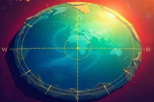
- GCS coordinates are based on angles created with reference to the center of the Earth, the equator, and the prime meridian, using latitude and longitude to define positions on or above the Earth's surface.
- Latitude and longitude are both involved in defining specific positions on Earth's surface, with latitude referencing the equator and longitude referencing the prime meridian.
- Latitude measures angular distance north or south in reference to the equator, while longitude measures angular distance east or west in reference to the prime meridian.
- The equator is the longest and most central latitude line, designated as 0-degrees latitude and separating the Earth's north and south hemispheres.
- The prime meridian is an arbitrarily assigned reference line, designated as 0-degrees longitude, from which longitudes east and west are measured, separating the eastern and western hemispheres.
- Elevation is a measurement that refers to a position's 90-degree vertical distance from sea level, with sea level defined as 0 meters of elevation.
- Latitude and longitude are measured in degrees, minutes, and seconds, with specific equivalencies for each unit of measurement, taking into account the Earth's oblate spheroid shape.
- 1-degree latitude is approximately equal to 364,000 feet or 110,947 meters, while 1-degree longitude is approximately equal to 288,200 feet or 87,843 meters.
- The Earth's equator is an imaginary circle that wraps around the Earth, perpendicular to the Earth's rotational axis, and the prime meridian runs through Greenwich, England.
- Understanding latitude and longitude requires defining the equator and prime meridian, as angles are defined in reference to these points, with latitude measuring north or south and longitude measuring east or west.
- GCS uses angles to define positions on Earth, with latitude and longitude providing a precise location, and elevation is measured as a vertical distance from sea level.
Studying That Suits You
Use AI to generate personalized quizzes and flashcards to suit your learning preferences.