Podcast
Questions and Answers
Explain the concept of latitude lines.
Explain the concept of latitude lines.
Latitude lines are imaginary horizontal lines on the earth’s surface, forming circles. There are 180 degrees of latitude, and the 0° line is known as the Equator.
What are longitude lines and how are they characterized?
What are longitude lines and how are they characterized?
Longitude lines are imaginary vertical lines on the earth’s surface, also known as meridians. Each meridian forms a semi-circle, and there are 360 degrees of longitude. The 0° line of longitude is known as the Prime Meridian.
How are geographical coordinates interpreted?
How are geographical coordinates interpreted?
Geographical coordinates such as 4512N 06023E are read as 45 degrees 12 minutes North, 60 degrees 23 minutes East.
Define the concept of antipodes in the context of geography.
Define the concept of antipodes in the context of geography.
What is the process for determining the coordinates of an antipode?
What is the process for determining the coordinates of an antipode?
Explain the concept of map projections.
Explain the concept of map projections.
What is the antipode of 01°22’S, 103°48’ E?
What is the antipode of 01°22’S, 103°48’ E?
How are latitude and longitude coordinates used in navigation?
How are latitude and longitude coordinates used in navigation?
Explain the Mercator projection and its characteristics.
Explain the Mercator projection and its characteristics.
Define a great circle and its significance.
Define a great circle and its significance.
What is a rhumb line and how does it appear on a Mercator projection map?
What is a rhumb line and how does it appear on a Mercator projection map?
Explain the characteristics of a rhumb line track.
Explain the characteristics of a rhumb line track.
What are the types of map projections mentioned in the text?
What are the types of map projections mentioned in the text?
Describe the size distortion on a Mercator projection map.
Describe the size distortion on a Mercator projection map.
What is the significance of a great circle track?
What is the significance of a great circle track?
Explain the concept of a rhumb line and its practical implications.
Explain the concept of a rhumb line and its practical implications.
What are the characteristics of a cylindrical map projection, specifically the Mercator projection?
What are the characteristics of a cylindrical map projection, specifically the Mercator projection?
Flashcards
Latitude Lines
Latitude Lines
Imaginary lines running parallel to the equator, measuring distance north or south (0° at equator, 90° at poles).
Longitude Lines (Meridians)
Longitude Lines (Meridians)
Imaginary lines running from North to South Pole, measuring distance east or west of the Prime Meridian (0° to 180°).
Geographical Coordinates
Geographical Coordinates
Combining latitude and longitude measurements to identify an exact location on Earth.
Antipodes
Antipodes
Signup and view all the flashcards
Finding Antipode Coordinates
Finding Antipode Coordinates
Signup and view all the flashcards
Map Projections
Map Projections
Signup and view all the flashcards
Mercator Projection
Mercator Projection
Signup and view all the flashcards
Great Circle
Great Circle
Signup and view all the flashcards
Rhumb Line
Rhumb Line
Signup and view all the flashcards
Mercator Projection Characteristics
Mercator Projection Characteristics
Signup and view all the flashcards
Cylindrical Map Projections
Cylindrical Map Projections
Signup and view all the flashcards
Study Notes
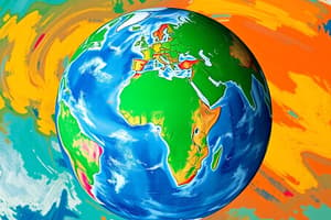
Latitude and Longitude
- Latitude lines are imaginary lines that run parallel to the equator, measuring distance north or south of the equator, ranging from 0° at the equator to 90° at the poles.
- Longitude lines, also known as meridians, are imaginary lines that run from the North Pole to the South Pole, measuring distance east or west of the Prime Meridian, ranging from 0° to 180°.
- Geographical coordinates are interpreted by combining latitude and longitude measurements to pinpoint a location on the Earth's surface.
Antipodes and Coordinates
- Antipodes are points on the Earth's surface that are diametrically opposite each other, meaning they are connected by a straight line through the center of the Earth.
- To determine the coordinates of an antipode, the latitude is inverted (i.e., N becomes S and vice versa) and the longitude is adjusted by adding or subtracting 180°.
Map Projections
- Map projections are methods of representing the curved Earth's surface on a two-dimensional map, which inevitably involves some distortion.
- The Mercator projection is a cylindrical map projection that preserves angles and shapes well, making it useful for navigation.
Navigation and Map Projections
- Latitude and longitude coordinates are used in navigation to determine a location and chart a course.
- The Mercator projection is commonly used in navigation due to its ability to preserve angles and shapes, making it useful for charting courses.
Rhumb Lines and Great Circles
- A great circle is the shortest path between two points on the Earth's surface, which appears as a straight line on a globe but is curved on a two-dimensional map.
- A rhumb line is a path that crosses all meridians at the same angle, which appears as a straight line on a Mercator projection map but is curved on a globe.
- Rhumb lines are used in navigation to chart a course, but they are not the shortest distance between two points.
Map Projection Characteristics
- The Mercator projection is a cylindrical map projection that preserves angles and shapes well, but distorts sizes and scales, particularly near the poles.
- Size distortion on a Mercator projection map increases as you move towards the poles.
Types of Map Projections
- Cylindrical map projections, such as the Mercator projection, preserve angles and shapes well but distort sizes and scales.
- Other types of map projections mentioned in the text include unknown types.
Studying That Suits You
Use AI to generate personalized quizzes and flashcards to suit your learning preferences.