Podcast
Questions and Answers
What is the geographic coordinate system?
What is the geographic coordinate system?
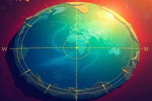
The geographic coordinate system is a system that uses latitude and longitude to specify locations on the globe.
What are latitude and longitude?
What are latitude and longitude?
Latitude and longitude are coordinates used in the geographic coordinate system to specify a location on the globe. Latitude measures the distance north or south of the Equator, while longitude measures the distance east or west of the Prime Meridian.
What is elevation?
What is elevation?
Elevation is the height of a location above or below a reference point, usually sea level.
What is the purpose of latitude and longitude?
What is the purpose of latitude and longitude?
How are latitude and longitude measured?
How are latitude and longitude measured?
What are some uses of the geographic coordinate system?
What are some uses of the geographic coordinate system?
What is elevation and how is it measured?
What is elevation and how is it measured?
What is the geographic coordinate system?
What is the geographic coordinate system?
What does latitude define?
What does latitude define?
What does the equator divide the Earth into?
What does the equator divide the Earth into?
What does longitude define?
What does longitude define?
What is the prime meridian?
What is the prime meridian?
What is the relationship between degrees, minutes, and seconds in the geographic coordinate system?
What is the relationship between degrees, minutes, and seconds in the geographic coordinate system?
What is the purpose of Study.com?
What is the purpose of Study.com?
Define latitude and explain how it is measured.
Define latitude and explain how it is measured.
What is the equator and what does it divide?
What is the equator and what does it divide?
How can you remember that latitude lines go across the globe?
How can you remember that latitude lines go across the globe?
Define longitude and explain how it is measured.
Define longitude and explain how it is measured.
What is the prime meridian and where is it believed to pass through?
What is the prime meridian and where is it believed to pass through?
When giving coordinates, which measurement is given first and which is given last?
When giving coordinates, which measurement is given first and which is given last?
Flashcards are hidden until you start studying