Podcast
Questions and Answers
Pangaea was surrounded by an ocean called Gondwana.
Pangaea was surrounded by an ocean called Gondwana.
False (B)
Alfred Wegener introduced the Plate Tectonics Theory in 1912.
Alfred Wegener introduced the Plate Tectonics Theory in 1912.
False (B)
The Indian Ocean was formed due to the southward drifting of India.
The Indian Ocean was formed due to the southward drifting of India.
False (B)
The movement of tectonic plates cannot be felt as it occurs at a very fast pace.
The movement of tectonic plates cannot be felt as it occurs at a very fast pace.
Laurasia included present-day North America, Europe, and Asia.
Laurasia included present-day North America, Europe, and Asia.
The Atlantic Ocean was formed as North America and South America drifted towards the east.
The Atlantic Ocean was formed as North America and South America drifted towards the east.
The continents have always remained fixed in their positions.
The continents have always remained fixed in their positions.
The crust of the Earth is made up of seven large tectonic plates.
The crust of the Earth is made up of seven large tectonic plates.
Mount Marcy is the highest point in the Adirondack Mountain Range at approximately 1,629 metres.
Mount Marcy is the highest point in the Adirondack Mountain Range at approximately 1,629 metres.
The Brooks Range has its highest point as Mount Rainier.
The Brooks Range has its highest point as Mount Rainier.
The Cascade Range is part of the Ring of Fire, known for its volcanic activity.
The Cascade Range is part of the Ring of Fire, known for its volcanic activity.
The Missouri River is longer than the Mississippi River.
The Missouri River is longer than the Mississippi River.
The Colorado River is primarily known for forming the Great Lakes.
The Colorado River is primarily known for forming the Great Lakes.
The St Lawrence River serves as a significant waterway in eastern Canada and drains the Great Lakes.
The St Lawrence River serves as a significant waterway in eastern Canada and drains the Great Lakes.
The Mackenzie River is the longest river in the United States.
The Mackenzie River is the longest river in the United States.
The Great Basin Desert is classified as a hot desert and mainly located in Nevada.
The Great Basin Desert is classified as a hot desert and mainly located in Nevada.
The Sonoran Desert spans parts of California, Arizona, and Mexico.
The Sonoran Desert spans parts of California, Arizona, and Mexico.
The Great Lakes consist of five lakes and hold 21 percent of the world's fresh water supply.
The Great Lakes consist of five lakes and hold 21 percent of the world's fresh water supply.
Christopher Columbus is believed to be the first to discover North America.
Christopher Columbus is believed to be the first to discover North America.
The United States was formed in the early 1900s.
The United States was formed in the early 1900s.
North America is located between the Arctic Ocean and the Southern Ocean.
North America is located between the Arctic Ocean and the Southern Ocean.
Greenland is an independent country.
Greenland is an independent country.
The Great Plains are characterized by vast high plateaus and semi-arid grasslands.
The Great Plains are characterized by vast high plateaus and semi-arid grasslands.
The Rocky Mountains are the largest mountain range in the world.
The Rocky Mountains are the largest mountain range in the world.
The Appalachian Mountains are the youngest mountain chain in North America.
The Appalachian Mountains are the youngest mountain chain in North America.
The highest peak in the Rocky Mountains is Mt Elbert.
The highest peak in the Rocky Mountains is Mt Elbert.
The Central Lowlands are ideal for cultivation due to their infertility.
The Central Lowlands are ideal for cultivation due to their infertility.
The Sierra Madre is located along Mexico's Pacific Coast.
The Sierra Madre is located along Mexico's Pacific Coast.
The Eastern Plateaus include the Appalachian Mountains and extend to the Gulf of Mexico.
The Eastern Plateaus include the Appalachian Mountains and extend to the Gulf of Mexico.
The Great Basin lies to the north of the Rocky Mountains.
The Great Basin lies to the north of the Rocky Mountains.
The Blue Ridge Mountains are part of the Sierra Madre.
The Blue Ridge Mountains are part of the Sierra Madre.
The most widely spoken languages in North America include English, Spanish, and French.
The most widely spoken languages in North America include English, Spanish, and French.
Flashcards are hidden until you start studying
Study Notes
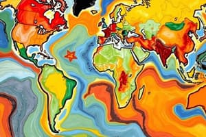
Formation of Continents
- Continents were once a single supercontinent named Pangaea, surrounded by the ocean Panthalassa.
- Alfred Wegener proposed the Continental Drift Theory in 1912, explaining the movement of continents.
- Pangaea split into two major blocks: Laurasia (North America, Europe, Asia) and Gondwana (South America, Africa, Australia, Antarctica, India).
- The Tethys Sea formed between Laurasia and Gondwana as they drifted apart.
- About 65 million years ago, North America separated from Laurasia; South America, Africa, India, Madagascar, Australia, and Antarctica separated from Gondwana.
- The Atlantic Ocean formed from the westward drift of North and South America; the Indian Ocean formed from India's northward drift.
- The Plate Tectonics Theory advanced the understanding of continental movement based on shifts in tectonic plates, moving slowly on the Earth's molten mantle.
History of North America
- Christopher Columbus is credited with discovering North America, but Vikings likely arrived first.
- Native American tribes and the Aztec civilization inhabited North America before European colonization.
- The United States, the most populous country in North America, emerged in the late 1700s and is considered a "melting pot" of cultures.
- Paleo-Indians are believed to be among the first inhabitants, migrating from Asia.
Location and Boundaries
- North America is situated in the Northern and Western Hemispheres, bordered by the Pacific, Atlantic, and Arctic Oceans.
- Major features include the Arctic Ocean to the north, the North Atlantic Ocean to the east, and the Caribbean Sea to the southeast.
- It connects to South America via the Isthmus of Panama, where the Panama Canal was constructed.
Countries and Capitals
- Major countries: Canada, USA, Mexico; smaller countries cluster in the central region.
- Greenland is an autonomous territory of Denmark, with Nuuk as its capital.
- English, Spanish, and French are the primary languages due to historical colonization.
Major Physical Features
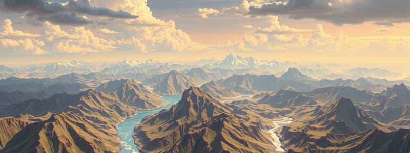
- Four main physical divisions: Western Cordilleras, Great Plains, Eastern Plateaus, Central Lowlands.
- Western Cordilleras: Features young fold mountains like the Rocky Mountains; important plateaus include the Columbia and Colorado Plateaus; includes the Grand Canyon.
- Great Plains: Vast semi-arid grasslands drained by major rivers.
- Eastern Plateaus: Extend from Hudson Bay to the Gulf of Mexico, include the Appalachian Mountains, Piedmont Plateau, and Atlantic Coastal Plain.
- Central Lowlands: Fertile plains suitable for agriculture and livestock.
Mountain Ranges
- Rocky Mountains: Longest mountain range in North America, with peak Mt. Elbert at 4,399 meters; diverse wildlife.
- Appalachian Mountains: Oldest mountain chain, running from Newfoundland to Alabama; includes popular subranges like the Great Smoky Mountains.
- Sierra Madre: Mountain range along Mexico’s Pacific Coast, characterized by rainforests and volcanoes; highest point is Mount Whitney.
- Adirondack Mountains: Located in New York, highest point is Mount Marcy; features the largest state park in the U.S.
- Brooks Range: Extends 1,100 km across Alaska, with Mount Chamberlin being the highest at 2,749 meters.
- Cascade Range: Known for volcanoes, part of the Pacific Ring of Fire, highest point is Mount Rainier.
Water Bodies
- North America is bordered by the Pacific, Atlantic, and Arctic Oceans and contains significant seas, gulfs, and bays.
- Major Rivers:
- Missouri River: Longest river (3,767 km), flows into the Mississippi.
- Mississippi River: Second longest (3,734 km), forms one of the largest drainage basins in the world.
- Colorado River: Notable for the Grand Canyon and significant dams; vital for water supply.
- St. Lawrence River: Major eastern Canadian waterway draining the Great Lakes.
- Hudson River: Historically significant, flows through New York.
- Mackenzie River: Longest river in Canada, flows into the Arctic Ocean.
Lakes
- Great Lakes: Comprising Lake Superior, Michigan, Huron, Erie, and Ontario; hold 21% of the world's fresh water supply, providing vital transportation routes.
Deserts
- North America features four deserts: Great Basin, Chihuahuan, Sonoran, and Mojave, primarily located in the western region.
- Great Basin Desert: Largest, cold desert mostly in Nevada.
- Chihuahuan Desert: Located along the US-Mexico border.
- Sonoran Desert: Found in California, Arizona, and Mexico, with major rivers flowing through.
- Mojave Desert: Positioned between the Great Basin and Sonoran deserts, spans California, Nevada, and Arizona.
Studying That Suits You
Use AI to generate personalized quizzes and flashcards to suit your learning preferences.