Podcast
Questions and Answers
What is the purpose of political maps?
What is the purpose of political maps?
The purpose of political maps is to show boundaries of nations, states, provinces, and other geopolitical divisions.
What do political maps illustrate?
What do political maps illustrate?
Political maps illustrate the distribution of power, cultural differences, and the location of political entities.
What features are commonly included in political maps?
What features are commonly included in political maps?
Political maps often include features like national flags, capital cities, and the names of political leaders.
How do country maps differ from administrative maps?
How do country maps differ from administrative maps?
Why are political maps considered essential tools?
Why are political maps considered essential tools?
What information do political maps convey using symbols, colors, and text?
What information do political maps convey using symbols, colors, and text?
What type of data do thematic maps display?
What type of data do thematic maps display?
How do topographic maps differ from thematic maps?
How do topographic maps differ from thematic maps?
Name two uses of political maps.
Name two uses of political maps.
How have political maps evolved with technology?
How have political maps evolved with technology?
What is the historical background of political maps?
What is the historical background of political maps?
Why are political maps considered essential tools?
Why are political maps considered essential tools?
Flashcards are hidden until you start studying
Study Notes
Maps: Unraveling Geographic Representations
Maps have evolved from simple depictions of environments to powerful tools that shape our understanding of the world. In this exploration, we'll delve into the fascinating world of maps, with a particular focus on the political map: a critical classification for geographic representation.
What Are Maps?
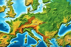
Maps are two-dimensional representations of the Earth's surface, created to illustrate physical and political features. Their purpose is to help us navigate, plan, and learn about our planet. Maps use symbols, colors, and text to convey information about geographic locations, such as roads, landmarks, and natural boundaries.
Political Maps
Political maps are specifically designed to show boundaries of nations, states, provinces, and other geopolitical divisions. They are an essential tool for understanding the world's political landscape, illustrating the distribution of power, cultural differences, and the location of political entities. Political maps often include features like national flags, capital cities, and the names of political leaders.
Types of Political Maps
- Country maps: These maps focus on the borders and names of countries, usually omitting other features.
- Administrative maps: These maps show the boundaries of political subdivisions, such as states, provinces, or counties, within a nation.
- Thematic maps: These maps display specific political data, such as demographics, population density, or voting patterns.
- Topographic maps: These maps combine physical and political features, showing elevation contours and boundaries.
Uses of Political Maps
- Planning and decision-making: Political maps help governments, businesses, and organizations to make informed decisions about resource allocation, infrastructure development, and environmental conservation.
- Education: Political maps are used in schools, colleges, and universities to teach students about geography, history, and political science.
- Travel and tourism: Political maps help travelers to navigate through countries, find tourist attractions, and understand cultural differences.
- Media and communication: Political maps are a powerful tool for news organizations, filmmakers, and other media professionals to communicate important events and issues to a global audience.
History of Political Maps
Political maps have a rich history, dating back to ancient civilizations. Early political maps were created using pen and ink, watercolors, and other traditional art mediums. With the advent of technology, political maps have become more sophisticated and dynamic, incorporating digital tools and GIS (Geographic Information Systems) technology.
Conclusion
Political maps serve as essential tools for understanding the world's political landscape. They help us to navigate, learn, and make informed decisions about our global community. As technology continues to evolve, political maps will undoubtedly become more advanced and sophisticated, providing us with new insights into the complexities of our planet.
Studying That Suits You
Use AI to generate personalized quizzes and flashcards to suit your learning preferences.