Podcast
Questions and Answers
[Blank] is the branch of geography dealing with natural features and processes.
[Blank] is the branch of geography dealing with natural features and processes.
Physical geography
[Blank] examines long-term weather patterns and climate change, including atmospheric conditions and their variations.
[Blank] examines long-term weather patterns and climate change, including atmospheric conditions and their variations.
Climatology
The ______ includes all forms of water on Earth, influencing both climate and weather patterns.
The ______ includes all forms of water on Earth, influencing both climate and weather patterns.
hydrosphere
[Blank] involves acquiring information from a distance using satellites and aircraft to monitor land cover and vegetation.
[Blank] involves acquiring information from a distance using satellites and aircraft to monitor land cover and vegetation.
The ______ consists of nitrogen, oxygen, and other gases and regulates temperature and weather patterns.
The ______ consists of nitrogen, oxygen, and other gases and regulates temperature and weather patterns.
[Blank] studies the distribution and movement of water on Earth, including surface water, groundwater, and the water cycle.
[Blank] studies the distribution and movement of water on Earth, including surface water, groundwater, and the water cycle.
[Blank] studies landforms and the processes that shape them, such as weathering, erosion, and tectonic activity.
[Blank] studies landforms and the processes that shape them, such as weathering, erosion, and tectonic activity.
The ______ includes all living organisms and their environments, interacting with the other Earth spheres to form ecosystems.
The ______ includes all living organisms and their environments, interacting with the other Earth spheres to form ecosystems.
[Blank] transforms land cover and drainage patterns, creating urban heat islands and altering local climates.
[Blank] transforms land cover and drainage patterns, creating urban heat islands and altering local climates.
The ______ includes the crust and upper mantle, with geological processes shaping its structure.
The ______ includes the crust and upper mantle, with geological processes shaping its structure.
[Blank] poses significant risks to human populations, causing widespread damage through earthquakes, floods, and hurricanes.
[Blank] poses significant risks to human populations, causing widespread damage through earthquakes, floods, and hurricanes.
[Blank] studies the distribution of species and ecosystems, exploring the influence of geographic factors on living organisms.
[Blank] studies the distribution of species and ecosystems, exploring the influence of geographic factors on living organisms.
[Blank] modifies landscapes and soil properties, leading to potential soil degradation and depletion of water resources if not managed sustainably.
[Blank] modifies landscapes and soil properties, leading to potential soil degradation and depletion of water resources if not managed sustainably.
[Blank] is a major global challenge that affects weather patterns and sea levels, requiring both mitigation and adaptation strategies.
[Blank] is a major global challenge that affects weather patterns and sea levels, requiring both mitigation and adaptation strategies.
[Blank] is the art and science of mapmaking, representing spatial information through various types of maps.
[Blank] is the art and science of mapmaking, representing spatial information through various types of maps.
[Blank] degrades air, water, and soil quality, harming human health and ecosystems through industrial activities, transportation, and agriculture.
[Blank] degrades air, water, and soil quality, harming human health and ecosystems through industrial activities, transportation, and agriculture.
[Blank] is a growing problem in many regions, where demand exceeds supply, necessitating critical water management strategies.
[Blank] is a growing problem in many regions, where demand exceeds supply, necessitating critical water management strategies.
[Blank] alters ecosystems and landscapes, leading to habitat loss, soil erosion, and contributions to climate change.
[Blank] alters ecosystems and landscapes, leading to habitat loss, soil erosion, and contributions to climate change.
[Blank] is used for spatial analysis, integrating and analyzing geographic data for mapping, modeling, and decision-making.
[Blank] is used for spatial analysis, integrating and analyzing geographic data for mapping, modeling, and decision-making.
[Blank] reduces soil fertility and productivity through erosion, desertification, and pollution, requiring sustainable land management practices to reverse.
[Blank] reduces soil fertility and productivity through erosion, desertification, and pollution, requiring sustainable land management practices to reverse.
Flashcards
Physical Geography
Physical Geography
Branch of geography focused on Earth's natural features and processes.
Geomorphology
Geomorphology
The study of landforms and the processes shaping them.
Climatology
Climatology
Examination of long-term weather patterns and climate change.
Hydrology
Hydrology
Signup and view all the flashcards
Biogeography
Biogeography
Signup and view all the flashcards
Soil Geography
Soil Geography
Signup and view all the flashcards
Atmosphere
Atmosphere
Signup and view all the flashcards
Lithosphere
Lithosphere
Signup and view all the flashcards
Hydrosphere
Hydrosphere
Signup and view all the flashcards
Biosphere
Biosphere
Signup and view all the flashcards
Weathering
Weathering
Signup and view all the flashcards
Erosion
Erosion
Signup and view all the flashcards
Remote Sensing
Remote Sensing
Signup and view all the flashcards
Geographic Information Systems (GIS)
Geographic Information Systems (GIS)
Signup and view all the flashcards
Cartography
Cartography
Signup and view all the flashcards
Deforestation
Deforestation
Signup and view all the flashcards
Urbanization
Urbanization
Signup and view all the flashcards
Agriculture
Agriculture
Signup and view all the flashcards
Climate Change
Climate Change
Signup and view all the flashcards
Loss of Biodiversity
Loss of Biodiversity
Signup and view all the flashcards
Study Notes
- Physical geography is the branch of geography dealing with natural features and processes.
- It is the study of Earth's physical features, climate, and natural processes.
- It is also known as physiography or Earth system science.
- It explores the spatial dimensions and temporal evolution of the Earth's natural systems.
- Physical geography focuses on understanding the patterns and processes of the physical environment.
- It helps to address environmental problems and sustainability issues.
- Physical geography intersects with various natural sciences.
- These include geology, climatology, hydrology, and ecology.
- It uses scientific methods to study physical phenomena.
- The discipline aims to understand the interactions between the atmosphere, biosphere, hydrosphere, and lithosphere.
Core Concepts and Subfields
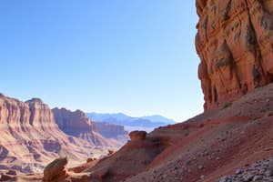
- Geomorphology studies landforms and the processes that shape them.
- It includes weathering, erosion, and tectonic activity.
- Fluvial geomorphology examines rivers and their impact on the landscape.
- Glacial geomorphology focuses on glaciers and their effects.
- Coastal geomorphology studies coastal processes and landforms.
- Climatology examines long-term weather patterns and climate change.
- It studies atmospheric conditions and their variations over time.
- Climatology analyzes factors influencing regional and global climates.
- Paleoclimatology reconstructs past climates to understand long-term trends.
- Hydrology studies the distribution and movement of water on Earth.
- It includes surface water, groundwater, and the water cycle.
- Hydrology examines water resources and their management.
- It also studies floods and droughts.
- Biogeography studies the distribution of species and ecosystems.
- It explores the influence of geographic factors on living organisms.
- Plant biogeography focuses on the distribution of plant species.
- Zoogeography studies the distribution of animal species.
- Soil geography examines the formation, distribution, and properties of soils.
- It studies the role of soil in supporting ecosystems.
- Soil geography analyzes soil composition and fertility.
- It also addresses soil degradation and conservation.
- Coastal and marine geography studies the interactions between land and sea.
- It examines coastal processes, marine ecosystems, and human impacts.
- Coastal geomorphology overlaps with this subfield.
- Environmental geography studies the interactions between humans and the environment.
- It examines environmental problems and their solutions.
- Environmental geography focuses on sustainability and conservation.
Earth's Spheres
- The atmosphere is the layer of gases surrounding Earth.
- It regulates temperature and weather patterns.
- The atmosphere consists of nitrogen, oxygen, and other gases.
- It protects the Earth from harmful solar radiation.
- The lithosphere is the Earth's solid outer layer.
- It includes the crust and upper mantle.
- Tectonic plates make up the lithosphere.
- Geological processes shape the lithosphere.
- The hydrosphere includes all forms of water on Earth.
- It consists of oceans, lakes, rivers, and ice.
- The hydrosphere influences climate and weather.
- Water is essential for life on Earth.
- The biosphere includes all living organisms and their environments.
- It interacts with the other Earth spheres.
- Ecosystems make up the biosphere.
- Biodiversity is a key aspect of the biosphere.
Processes and Systems
- Tectonic processes shape the Earth's surface.
- Plate tectonics drives mountain building and volcanic activity.
- Earthquakes result from tectonic movements.
- These processes influence landform development.
- Weathering breaks down rocks and minerals.
- Physical weathering involves mechanical disintegration.
- Chemical weathering involves alteration of rock composition.
- Biological weathering involves the action of living organisms.
- Erosion transports weathered materials.
- Water, wind, and ice are agents of erosion.
- Erosion shapes landscapes over time.
- Deposition occurs when eroded materials settle.
- Climate patterns influence vegetation and ecosystems.
- Temperature and precipitation are key climate factors.
- Biomes are large-scale ecosystems characterized by specific climates and vegetation.
- Climate change is altering global climate patterns.
- Hydrological cycle describes the movement of water.
- Evaporation, condensation, and precipitation are key processes.
- Runoff and infiltration influence water distribution.
- Water resources are essential for human activities and ecosystems.
Tools and Techniques
- Remote sensing involves acquiring information from a distance.
- Satellites and aircraft are used for remote sensing.
- It provides data on land cover, vegetation, and other features.
- Remote sensing aids in environmental monitoring.
- Geographic Information Systems (GIS) are used for spatial analysis.
- GIS integrates and analyzes geographic data.
- It is used for mapping, modeling, and decision-making.
- GIS helps in visualizing spatial patterns.
- Cartography is the art and science of mapmaking.
- Maps represent spatial information.
- Various types of maps serve different purposes.
- Map projections transform the Earth's spherical surface onto a flat plane.
- Statistical analysis is used to analyze geographic data.
- Statistical methods identify patterns and relationships.
- It helps in understanding spatial distributions.
- Quantitative techniques are important in physical geography.
- Fieldwork involves direct observation and data collection.
- Fieldwork provides ground truth information.
- It enhances understanding of physical processes.
- Field observations complement remote sensing and GIS data.
Human-Environment Interactions
- Deforestation alters ecosystems and landscapes.
- It leads to habitat loss and soil erosion.
- Deforestation contributes to climate change.
- Sustainable forestry practices mitigate these impacts.
- Urbanization transforms land cover and drainage patterns.
- It creates urban heat islands.
- Urban runoff can pollute water bodies.
- Green infrastructure helps to mitigate these effects.
- Agriculture modifies landscapes and soil properties.
- Intensive agriculture can lead to soil degradation.
- Irrigation can deplete water resources.
- Sustainable agricultural practices conserve soil and water.
- Climate change impacts natural systems and human societies.
- Rising temperatures, sea-level rise, and extreme weather events are consequences.
- Mitigation and adaptation strategies are needed to address climate change.
- Pollution degrades air, water, and soil quality.
- Industrial activities, transportation, and agriculture are major sources.
- Pollution harms human health and ecosystems.
- Environmental regulations aim to reduce pollution.
Contemporary Issues
- Climate change is a major global challenge.
- It affects weather patterns and sea levels.
- Impacts vary by region.
- Mitigation and adaptation are crucial.
- Loss of biodiversity threatens ecosystems.
- Habitat destruction and invasive species are major causes.
- Conservation efforts are essential.
- Water scarcity is a growing problem in many regions.
- Demand exceeds supply in some areas.
- Water management is critical.
- Land degradation reduces soil fertility and productivity.
- Erosion, desertification, and pollution are contributing factors.
- Sustainable land management practices can reverse degradation.
- Natural disasters pose significant risks to human populations.
- Earthquakes, floods, and hurricanes cause widespread damage.
- Disaster preparedness and mitigation are essential.
Studying That Suits You
Use AI to generate personalized quizzes and flashcards to suit your learning preferences.