Podcast
Questions and Answers
Which region is not drained by the Abbay and its tributaries?
Which region is not drained by the Abbay and its tributaries?
- The Southwestern Highlands
- The North and Western Highlands
- The Southeastern Highlands
- The Central Highlands (correct)
Which river separates the north central Massif from the plateau of Tigray?
Which river separates the north central Massif from the plateau of Tigray?
- Tekezze River (correct)
- Mereb River
- Abbey River
- The Danakil Lowlands
Identify the smallest subdivision of the western highlands.
Identify the smallest subdivision of the western highlands.
- North central massif (correct)
- Semein mountain
- Tigrean plateau
- Shewan plateau
In which geological era did landforms of Ethiopia significantly develop?
In which geological era did landforms of Ethiopia significantly develop?
What geological era is characterized by the predominance of invertebrates?
What geological era is characterized by the predominance of invertebrates?
What is required for the reproduction or transmission of this textbook?
What is required for the reproduction or transmission of this textbook?
Which universities contributed to the development of this textbook?
Which universities contributed to the development of this textbook?
According to the Ethiopian copyright law, what must be done if copyrighted material is improperly cited?
According to the Ethiopian copyright law, what must be done if copyrighted material is improperly cited?
What is the ISBN number provided for this textbook?
What is the ISBN number provided for this textbook?
Where is the head office of the Ministry of Education located?
Where is the head office of the Ministry of Education located?
What is indicated as a fundamental right in terms of the ownership of copyrighted material?
What is indicated as a fundamental right in terms of the ownership of copyrighted material?
What form of gratitude is extended by the Ministry of Education?
What form of gratitude is extended by the Ministry of Education?
Which neighboring country shares the longest boundary line with Ethiopia?
Which neighboring country shares the longest boundary line with Ethiopia?
What is the total length of Ethiopia's shared boundary lines with neighboring countries?
What is the total length of Ethiopia's shared boundary lines with neighboring countries?
Which country shares the shortest boundary line with Ethiopia?
Which country shares the shortest boundary line with Ethiopia?
What is the absolute location of Ethiopia in terms of geographical extent?
What is the absolute location of Ethiopia in terms of geographical extent?
In which region is Ethiopia located relative to the Indian Ocean?
In which region is Ethiopia located relative to the Indian Ocean?
Ethiopia's strategic location can be characterized as being in which basin?
Ethiopia's strategic location can be characterized as being in which basin?
Which descriptor best defines the term 'strategic location' as described for Ethiopia?
Which descriptor best defines the term 'strategic location' as described for Ethiopia?
How is the geographical extent of Ethiopia expressed in terms of global location?
How is the geographical extent of Ethiopia expressed in terms of global location?
Which sea is located to the southwest of Ethiopia?
Which sea is located to the southwest of Ethiopia?
Which mountain peak is the highest in the mentioned Massif?
Which mountain peak is the highest in the mentioned Massif?
What separates the Plateau of Shewa from the southeastern highlands?
What separates the Plateau of Shewa from the southeastern highlands?
Which of the following regions is NOT part of the southwestern highlands?
Which of the following regions is NOT part of the southwestern highlands?
Which mountain in the Plateau of Shewa is listed as the lowest in altitude?
Which mountain in the Plateau of Shewa is listed as the lowest in altitude?
What is the average annual rainfall in the southwestern highlands?
What is the average annual rainfall in the southwestern highlands?
Which river flows southwards from the southwestern highlands ending in Lake Turkana?
Which river flows southwards from the southwestern highlands ending in Lake Turkana?
Mount Tefaw Lezer reaches what altitude above mean sea level?
Mount Tefaw Lezer reaches what altitude above mean sea level?
Which mountain marks the highest point in the southwestern highlands?
Which mountain marks the highest point in the southwestern highlands?
Which river tributary drains the Plateau of Shewa towards the west?
Which river tributary drains the Plateau of Shewa towards the west?
What shape does the Shewan Plateau resemble?
What shape does the Shewan Plateau resemble?
What percentage of Ethiopia's land is classified as highland based on the demarcating contour line of 1000 meters?
What percentage of Ethiopia's land is classified as highland based on the demarcating contour line of 1000 meters?
Which physiological division does NOT belong to the categorization of Ethiopia's relief?
Which physiological division does NOT belong to the categorization of Ethiopia's relief?
What is the main geographical feature that separates the Western Highlands from the Southeastern Highlands?
What is the main geographical feature that separates the Western Highlands from the Southeastern Highlands?
Which of the following rivers is NOT mentioned as emerging from the Western Highlands?
Which of the following rivers is NOT mentioned as emerging from the Western Highlands?
Which of the following correctly lists the subdivisions of the Western Highlands?
Which of the following correctly lists the subdivisions of the Western Highlands?
What is the effect of Ethiopia's highland proportion on its geopolitical role?
What is the effect of Ethiopia's highland proportion on its geopolitical role?
Which geological force is NOT mentioned as a contributor to the creation of Ethiopia's landforms?
Which geological force is NOT mentioned as a contributor to the creation of Ethiopia's landforms?
How is the Rift Valley described in relation to Ethiopia's topography?
How is the Rift Valley described in relation to Ethiopia's topography?
What does the term 'penepalanation' refer to in relation to Ethiopia's landform creation?
What does the term 'penepalanation' refer to in relation to Ethiopia's landform creation?
Flashcards
Geography
Geography
The study of the Earth's physical features, including landforms, water bodies, and climate.
Location of Ethiopia
Location of Ethiopia
The position of Ethiopia on the globe, including its latitude and longitude.
Size of Ethiopia
Size of Ethiopia
The total area covered by Ethiopia, expressed in square kilometers or miles.
Shape of Ethiopia
Shape of Ethiopia
Signup and view all the flashcards
Geological History of Ethiopia
Geological History of Ethiopia
Signup and view all the flashcards
Climate
Climate
Signup and view all the flashcards
Controls of Climate
Controls of Climate
Signup and view all the flashcards
Metamorphic Rock
Metamorphic Rock
Signup and view all the flashcards
What area is NOT drained by the Abbay River?
What area is NOT drained by the Abbay River?
Signup and view all the flashcards
What separates the north central Massif and the plateau of Tigray?
What separates the north central Massif and the plateau of Tigray?
Signup and view all the flashcards
What is the smallest subdivision of the Western Highlands?
What is the smallest subdivision of the Western Highlands?
Signup and view all the flashcards
What geological era was significant for Ethiopian landform formation?
What geological era was significant for Ethiopian landform formation?
Signup and view all the flashcards
Boundary Line Length
Boundary Line Length
Signup and view all the flashcards
Ethiopia's Total Boundary Line Length
Ethiopia's Total Boundary Line Length
Signup and view all the flashcards
Ethiopia's Longest Border
Ethiopia's Longest Border
Signup and view all the flashcards
Ethiopia's Shortest Border
Ethiopia's Shortest Border
Signup and view all the flashcards
Strategic Location
Strategic Location
Signup and view all the flashcards
Absolute Location
Absolute Location
Signup and view all the flashcards
Ethiopia's Strategic Location
Ethiopia's Strategic Location
Signup and view all the flashcards
Ethiopia's Absolute Location
Ethiopia's Absolute Location
Signup and view all the flashcards
Ethiopia's Location in the Nile Basin
Ethiopia's Location in the Nile Basin
Signup and view all the flashcards
Shewan Plateau
Shewan Plateau
Signup and view all the flashcards
Mount Ras Dashen
Mount Ras Dashen
Signup and view all the flashcards
Mount Legeda
Mount Legeda
Signup and view all the flashcards
Simien Massif
Simien Massif
Signup and view all the flashcards
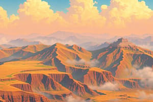
Southwestern Highlands
Southwestern Highlands
Signup and view all the flashcards
Abbay River
Abbay River
Signup and view all the flashcards
Drainage of the Southwestern Highlands
Drainage of the Southwestern Highlands
Signup and view all the flashcards
Dabus River
Dabus River
Signup and view all the flashcards
Didesa River
Didesa River
Signup and view all the flashcards
Omo-Gibe River
Omo-Gibe River
Signup and view all the flashcards
Ethiopian Highlands
Ethiopian Highlands
Signup and view all the flashcards
Rift Valley
Rift Valley
Signup and view all the flashcards
Endogenic Forces
Endogenic Forces
Signup and view all the flashcards
Exogenic Forces
Exogenic Forces
Signup and view all the flashcards
Western Highlands
Western Highlands
Signup and view all the flashcards
Plateau of Tigray
Plateau of Tigray
Signup and view all the flashcards
North Central Massif
North Central Massif
Signup and view all the flashcards
Plateau of Shewa
Plateau of Shewa
Signup and view all the flashcards
Study Notes
Textbook Information
- The textbook is a Geography student textbook for Grade 9.
- It was published in 2022 in Ethiopia.
- The book was written by Muluemebet Worku (PhD) and Kidanemariam Paulos (PhD).
- The editors include Sintayehu Teka (MSc), Kassie Molla (MA), and Hirut Woldemichael (MA).
- The illustrator is Agenchw Nega (MSc), and the designer is Geda Hoka (MA.)
- Evaluators were involved in the book.
- The Ministry of Education, Federal Democratic Republic of Ethiopia, is the publisher.
- The supporting organizations (donors or sponsors) include; the World Bank, UK's Department of International Development/DFID (Merged FCDO), Finnish Ministry for Foreign Affairs, the Royal Norwegian Embassy, UNICEF, the Global Partnership for Education (GPE), and the Danish Ministry for Foreign Affairs.
- The book is being used for the general education curriculum in Ethiopia.
Textbook Care Instructions
- Cover the textbook with protective materials.
- Keep the book in a clean, dry place.
- Keep hands clean when using the book.
- Do not write on the cover or inside pages.
- Use a bookmark to protect the pages.
- Do not tear or cut out pages.
- Repair torn pages with paste or tape.
- Pack the book carefully in a bag.
- Handle the book with care when passing to another person.
- When using a new textbook, lay it flat and open a few pages at a time.
- Press lightly along the bound edge as you turn the pages.
Table of Contents
- Unit One: Geological History and Topography of Ethiopia (pages 1-35)
- Unit Two: Climate of Ethiopia (pages 37-57)
- Unit Three: Natural Resource Base of Ethiopia (pages 59-85)
- Unit Four: Population and Demographic Characteristics of Ethiopia (pages 87-121)
- Unit Five: Major Economic and Cultural Activities in Ethiopia (pages 123-156)
- Unit Six: Human - Natural Environment Interactions in Ethiopia (pages 159-184)
- Unit Seven: Contemporary Geographic Issues and Public Concerns in Ethiopia (pages 185-200)
- Unit Eight: Geography Inquiry Skills and Techniques (pages 201-234)
Studying That Suits You
Use AI to generate personalized quizzes and flashcards to suit your learning preferences.