Podcast
Questions and Answers
What is a vertical angle in surveying?
What is a vertical angle in surveying?
- An angle measured between two lines in a plane that is diagonal at a point.
- An angle measured between two lines in a plane that is horizontal at a point.
- An angle measured between two lines in a plane that is vertical at a point. (correct)
- An angle measured between two lines in a plane that is circular at a point.
What is one of the dangers of field work in surveying?
What is one of the dangers of field work in surveying?
- Poor visibility (correct)
- Insufficient funding
- Inadequate training
- Lack of machinery
What is one of the safety precautions in surveying?
What is one of the safety precautions in surveying?
- Wearing safety clothes (correct)
- Using a GPS device
- Using a ladder
- Working alone
What is the main difference between a map and a plan?
What is the main difference between a map and a plan?
What is the scale of a map or plan?
What is the scale of a map or plan?
What is the purpose of conventional symbols on a map?
What is the purpose of conventional symbols on a map?
What is the metric system of measurement?
What is the metric system of measurement?
What is the British system of measurement?
What is the British system of measurement?
How do you convert a planned distance to an actual distance?
How do you convert a planned distance to an actual distance?
What is the actual area if the planned distance is 25mm and the scale is 1/4?
What is the actual area if the planned distance is 25mm and the scale is 1/4?
What is the main objective of surveying?
What is the main objective of surveying?
Who divided the land of Egypt into plots for the purpose of taxation?
Who divided the land of Egypt into plots for the purpose of taxation?
What was the name of the first survey equipment referred to in ancient Egypt?
What was the name of the first survey equipment referred to in ancient Egypt?
What is the term used to describe the earliest surveyors?
What is the term used to describe the earliest surveyors?
What is the general term used to describe the science of surveying?
What is the general term used to describe the science of surveying?
What are the two main steps involved in surveying work?
What are the two main steps involved in surveying work?
What is the primary role of a surveyor?
What is the primary role of a surveyor?
In what year was the oldest map in Egypt created?
In what year was the oldest map in Egypt created?
What is the primary focus of surveying?
What is the primary focus of surveying?
What is the term used to describe a professional person with academic qualifications and technical expertise in the surveying sector?
What is the term used to describe a professional person with academic qualifications and technical expertise in the surveying sector?
What is the main purpose of the Fieldwork in Engineering Surveying?
What is the main purpose of the Fieldwork in Engineering Surveying?
Which type of surveying is used for small areas of the earth?
Which type of surveying is used for small areas of the earth?
What is the main purpose of the Office work in Engineering Surveying?
What is the main purpose of the Office work in Engineering Surveying?
What is Aerial Surveying (Photogrammetric) used for?
What is Aerial Surveying (Photogrammetric) used for?
What is the main difference between Plane Surveying and Geodetic surveying?
What is the main difference between Plane Surveying and Geodetic surveying?
What is the main application of surveying in preparing a topographic map?
What is the main application of surveying in preparing a topographic map?
What is Ground surveying?
What is Ground surveying?
What is the main purpose of surveying in preparing a cadastral map?
What is the main purpose of surveying in preparing a cadastral map?
What is the main application of surveying in preparing a geological map?
What is the main application of surveying in preparing a geological map?
What is the main classification of surveying?
What is the main classification of surveying?
What is the main characteristic of geodetic surveying?
What is the main characteristic of geodetic surveying?
What is the purpose of control survey?
What is the purpose of control survey?
What type of survey is used to define highways and railroads?
What type of survey is used to define highways and railroads?
What is measured in a horizontal plane?
What is measured in a horizontal plane?
What type of survey is used to measure the manufacturing process?
What type of survey is used to measure the manufacturing process?
What is the purpose of As-Built surveys?
What is the purpose of As-Built surveys?
What type of survey uses photogrammetry or remote sensing?
What type of survey uses photogrammetry or remote sensing?
What is measured along the direction of gravity?
What is measured along the direction of gravity?
What type of survey is used to define shorelines and depths of lakes?
What type of survey is used to define shorelines and depths of lakes?
What is the purpose of Construction surveys?
What is the purpose of Construction surveys?
Flashcards are hidden until you start studying
Study Notes
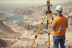
Introduction to Engineering Surveying
- Surveying (Geomatics) is the art of determining the relative position of different objects and the relative vertical distances of different points on the surface of the earth.
History of Surveying
- The science of surveying began in Egypt around 1400 B.C.
- Sesostris divided the land of Egypt into plots for the purpose of taxation.
- Early surveyors were called rope-stretchers since their measurements were made with ropes having markers at unit distances.
- The oldest map in Egypt dates back to 1400 B.C.
- The first survey equipment referred to, the Dioptra, was mentioned in 120 B.C.
Surveyor
- A surveyor is a professional person with academic qualifications and technical expertise in the surveying sector.
- Surveying work is divided into two main steps: Fieldwork and Office work.
- Fieldwork involves determining the relative location of points and setting out or staking out points.
- Office work involves research and analysis of data, processing the obtained data, and preparing maps and charts.
Applications of Surveying
- Surveying has various applications, including:
- Preparing topographic maps (Hills, and valleys)
- Preparing cadastral maps (Boundary)
- Preparing military maps
- Preparing geological maps (underground sources)
- Preparing archeological maps
Classification of Surveying
- Surveying can be classified into two main types: Ground surveying and Aerial Surveying (Photogrammetric)
- Ground surveying can be further divided into:
- Plane surveying: used for small areas of the earth (not exceeding 250 km²)
- Geodetic surveying: used for large areas of the earth (exceeding about 250 km²)
Types of Surveys
- There are several specialized types of surveys, including:
- Control Survey: establishes the network of monuments
- Topographic surveys: locations and elevations of natural and artificial features
- Cadastral surveys: establish property lines
- Hydrographic surveys: define shorelines and depths of lakes, oceans, and reservoirs
- Alignment (Route) surveys: define highways, railroads, electricity transmission lines, and channels
- Construction surveys: layout surveys for construction works
- As-Built surveys: final layout of engineering works
- Mine surveys: all operations associated with the mine
- Solar Surveys: obstruction and access of solar sources
- Industrial surveys (Optical alignment): measurement of the manufacturing process
- Ground surveys: level and total station
- Aerial surveys: photogrammetry or remote sensing
- Satellite surveys: GPS
Basic Measurement in Surveying
- Horizontal distance: a distance measured in a horizontal plane
- Vertical distance: a distance measured along the direction of gravity at that point
- Horizontal Angle: an angle measured between two lines in a horizontal plane at that point
- Vertical Angle: an angle measured between two lines in a plane that is vertical at a point
Safety in Surveying
- Fieldwork may involve dangers and safety precautions must be taken, such as:
- Using heavy machinery
- Dealing with poor visibility
- Working in noisy environments
- Working in bad weather
- Encountering animals
- To prevent accidents, safety measures should be taken, including:
- First aid kit
- Safety clothes
- Sign and safety string
- Colored flags
Studying That Suits You
Use AI to generate personalized quizzes and flashcards to suit your learning preferences.