Podcast
Play an AI-generated podcast conversation about this lesson
Download our mobile app to listen on the go
Get App
Questions and Answers
What is the definition of Altitude?
What is the definition of Altitude?
- The distance of a place from the equator
- A high, steep rock
- The elevation of an object in relation to sea level (correct)
- A body of water interspersed with many isles
What does Archipelago mean?
What does Archipelago mean?
A body of water interspersed with many isles
What is an Atoll?
What is an Atoll?
A ring-shaped coral reef surrounding a lagoon
Define 'Basin'.
Define 'Basin'.
Signup and view all the answers
What does the term 'Continent' refer to?
What does the term 'Continent' refer to?
Signup and view all the answers
What is a Gulf?
What is a Gulf?
Signup and view all the answers
What is the definition of Delta?
What is the definition of Delta?
Signup and view all the answers
What is a 'Headland'?
What is a 'Headland'?
Signup and view all the answers
Define 'Marsh'.
Define 'Marsh'.
Signup and view all the answers
What does 'Latitude' measure?
What does 'Latitude' measure?
Signup and view all the answers
What is a 'Peninsula'?
What is a 'Peninsula'?
Signup and view all the answers
What defines a 'Canyon'?
What defines a 'Canyon'?
Signup and view all the answers
What is the meaning of 'Ocean'?
What is the meaning of 'Ocean'?
Signup and view all the answers
Define 'Estuary'.
Define 'Estuary'.
Signup and view all the answers
Flashcards are hidden until you start studying
Study Notes
A-Z Geography Terms & Features
- Altitude: The height of an object relative to a reference point, commonly sea level.
- Archipelago: A cluster of islands surrounding a body of water.
- Arm: A narrow water passage, similar to a creek.
- Atoll: A ring-shaped coral formation encircling a lagoon.
- Bank: A steep incline rising from bodies of water such as lakes and rivers.
- Basin: A sunken area for water, often forming a bay within a narrow entrance.
- Bay: A body of water extending into the land, smaller than a gulf but larger than a creek.
- Bayou: A slow-moving, swampy waterway obstructed by vegetation.
- Beach: The shoreline of a lake or sea, shaped by tides and waves.
- Bluff: A nearly vertical, high bank jutting into water bodies.
- Bog: Soft, wet ground covered with vegetation, unable to support heavy weight.
- Branch: A smaller stream that feeds into a larger one.
- Breakers: Waves crashing against rocks or shore, creating foam.
- Brink: The edge of a steep terrain, such as a riverbank or cliff.
- Brook: A small, natural water stream.
- Canal: An artificial channel for water transportation.
- Canyon: A deep valley with steep rocky sides, formed by water erosion.
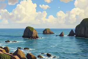
- Cape: A prominent land point extending into a body of water.
- Cave: A hollow underground space, can be natural or man-made.
- Cavern: A deep, natural underground chamber.
- Channel: A narrow body of water, like a strait, between land masses.
- Chasm: A deep fissure in the Earth's surface.
- Cinder cone: A hill formed from volcanic debris surrounding a vent.
- Cliff: A steep rock face, typically found on coasts.
- Coast: The border between land and sea.
- Continent: A continuous large landmass not broken by seas.
- Continental Shelf: The submerged edge of a continent.
- Country: A distinct region of land, often recognized as a state.
- Cove: A small bay or inlet along a shoreline.
- Crag: A rugged, steep rocky outcrop.
- Crater: The opening at the top of a volcano.
- Creek: A small stream or narrow inlet.
- Cultivated Land: Land prepared and used for agricultural crops.
- Current: A moving body of water like a stream or tide.
- Dale: A low area between hills or mountains.
- Dam: A structure built to obstruct water flow.
- Dell: A small, wooded valley.
- Delta: A landform where a river splits into several smaller parts before flowing into a larger body of water.
- Desert: A dry, arid region with little precipitation.
- Dike: An earth formation designed to control water flow.
- Divide: A ridge that separates different drainage areas.
- Downstream: The direction in which a river flows.
- Drainage Basin: The area drained by a river and its tributaries.
- Dune: A hill or ridge of sand formed by wind.
- Earth: The planet we inhabit, consisting of land and water.
- Elevation: An area of raised ground such as hills or mountains.
- Estuary: A coastal area where freshwater meets saltwater.
- Fall Line: The transition zone between upland and lowland areas where rivers drop in elevation.
- Field: Land used for agriculture or grazing.
- Fjord: A deep, narrow valley submerged by ocean water, created by glacial activity.
- Foothill: The lower slopes of a mountain.
- Ford: A shallow place in a river for crossing.
- Forest: A significant area covered in trees and vegetation.
- Glacier: A massive body of ice formed in cold regions.
- Glen: A narrow valley between hills.
- Gorge: A narrow valley with steep sides formed by erosion.
- Grove: A small group of trees.
- Gulch: A small, steep-walled valley caused by a stream.
- Gulf: A large bay or recess in the ocean along a coastline.
- Harbor: A sheltered area of water for ships and boats.
- Headland: A prominent point of land extending into the sea.
- Hill: A naturally raised area of land.
- Horizon: The line where the Earth meets the sky.
- Iceberg: A floating mass of ice that has broken off from a glacier.
- Inlet: A narrow body of water between land and islands.
- Irrigated Land: Land that is supplied with water for farming through artificial means.
- Island: A landmass surrounded by water.
- Isthmus: A narrow strip of land connecting two larger land areas.
- Junction: A point where two or more entities meet or connect.
- Keys: Small islands or coral reefs.
- Knob: A small, rounded hill.
- Knoll: A small mound or hill.
- Lagoon: A shallow body of saltwater separated from the ocean by land.
- Lake: A large inland body of water.
- Land: The solid surface of the Earth.
- Latitude: The angular distance of a place north or south of the equator.
- Ledge: A narrow shelf or ridge of rock.
- Left Bank: The left side of a river when facing downstream.
- Levee: A raised bank along a river to prevent flooding.
- Locks: A mechanism in a canal to raise or lower boats between sections of water.
- Longitude: The distance of a location from the prime meridian, measured in degrees.
- Marsh: Wetland areas dominated by herbaceous plants.
- Meadow: Grassland typically used for hay production.
- Mesa: A flat-topped hill with steep sides.
- Mine: An excavation for obtaining minerals and other materials.
- Moor: An area of open, uncultivated land.
- Mountain: A significant elevation of land, typically over 1,000 feet.
- Mountain Chain: A sequence of connected mountains.
- Mountain Range: A series of mountains connected by high ground.
- Mouth: The entrance or opening of a waterway.
- Natural Resource: Materials from the Earth with economic value.
- Oasis: A fertile area in a desert with water sources.
- Ocean: A vast body of saltwater covering most of the planet's surface.
- Pass: A navigable route through mountain ranges.
- Pasture: Land covered with grass for grazing livestock.
- Peak: The pointed top of a mountain or hill.
- Peninsula: A landform surrounded by water on three sides.
- Piedmont: The area at the base of a mountain.
- Pier: A structure extending into a body of water for boat access.
- Plain: An extensive area of flat land.
Studying That Suits You
Use AI to generate personalized quizzes and flashcards to suit your learning preferences.