Podcast
Questions and Answers
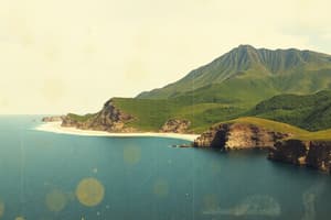
What is an Atoll?
What is an Atoll?
- A submerged cave
- A long, narrow, wave-built island
- A ring-shaped island of coral reefs (correct)
- A body of water partially surrounded by land
What describes a Backshore?
What describes a Backshore?
- Sand on the shoreward side of the berm crest (correct)
- A type of coral reef
- Sand on the seaward side of the berm
- A vertical wall marking high tides
Define Backwash.
Define Backwash.
Water returning to the ocean from waves washing onto a beach.
What is a Barrier Island?
What is a Barrier Island?
What is a Barrier Reef?
What is a Barrier Reef?
Define Bay Mouth Bar.
Define Bay Mouth Bar.
What constitutes a Beach?
What constitutes a Beach?
What is a Beach Scarp?
What is a Beach Scarp?
What is a Berm?
What is a Berm?
Define Berm Crest.
Define Berm Crest.
What is a Breakwater?
What is a Breakwater?
Define Coast.
Define Coast.
What is a Coastal Cell?
What is a Coastal Cell?
What is a Coral Reef?
What is a Coral Reef?
Define Delta.
Define Delta.
What characterizes a Depositional Coast?
What characterizes a Depositional Coast?
What is a Drumlins?
What is a Drumlins?
Define Erosion.
Define Erosion.
What defines an Erosional Coast?
What defines an Erosional Coast?
What is an Estuary?
What is an Estuary?
Define Eustatic Change.
Define Eustatic Change.
What is a Fjord?
What is a Fjord?
What is a Fjord Estuary?
What is a Fjord Estuary?
Define Foreshore.
Define Foreshore.
What is a Fringing Reef?
What is a Fringing Reef?
Define Groin.
Define Groin.
What characterizes a High-Energy Coast?
What characterizes a High-Energy Coast?
What is an Inlet?
What is an Inlet?
Define Lagoon.
Define Lagoon.
What is a Longshore Bar?
What is a Longshore Bar?
Define Longshore Current.
Define Longshore Current.
What is Longshore Drift?
What is Longshore Drift?
What is a Longshore Trough?
What is a Longshore Trough?
What characterizes a Low-Energy Coast?
What characterizes a Low-Energy Coast?
Define Low-Tide Terrace.
Define Low-Tide Terrace.
What is a Moraine?
What is a Moraine?
Define Partially Mixed Estuary.
Define Partially Mixed Estuary.
What is a Reverse Estuary?
What is a Reverse Estuary?
What is a Rip Current?
What is a Rip Current?
Define Salt Wedge Estuary.
Define Salt Wedge Estuary.
What is a Sand Spit?
What is a Sand Spit?
Define Sand Bar.
Define Sand Bar.
What is a Sea Cave?
What is a Sea Cave?
What characterizes a Sea Cliff?
What characterizes a Sea Cliff?
What is a Sea Island?
What is a Sea Island?
Define Shore.
Define Shore.
What is the Supralittoral Zone?
What is the Supralittoral Zone?
Define Swash.
Define Swash.
What is a Tombolo?
What is a Tombolo?
Define Wave-Cut Platform.
Define Wave-Cut Platform.
What is a Well-Mixed Estuary?
What is a Well-Mixed Estuary?
Flashcards are hidden until you start studying
Study Notes
Coastal Geography Vocabulary
- Atoll: Ring-shaped coral island encircling a lagoon, often formed over submerged, inactive volcanoes.
- Backshore: Zone of sand located landward of the berm crest, sloping away from the ocean.
- Backwash: Water that flows back into the ocean after waves wash onto the beach.
- Barrier Island: Long, narrow island built by waves, running parallel to the mainland and separated by a lagoon or bay.
- Barrier Reef: Coral reef surrounding an island or paralleling the mainland shore, with a deep lagoon in between.
- Bay Mouth Bar: Sandbar attached to a headland, extending across the entrance of a bay.
- Beach: Zone of loose particles from below water level to the coastal edge.
- Beach Scarp: Vertical wall indicating the landward limit of the latest high tides, aligning with the berm during extreme high tides.
- Berm: Nearly horizontal sediment accumulation parallel to shore, indicating normal sand deposition limits by wave action.
- Berm Crest: Highest point on the beach, denoting the shoreward limit of wave action during high tides.
- Breakwater: Artificial structure reducing wave impact on shore, commonly safeguarding harbors.
- Coast: Area stretching from the ocean inland, affected directly by marine processes.
- Coastal Cell: Natural section of coastline where sand input equals sand outflow.
- Coral Reef: Structure of calcium carbonate formed by a combination of marine organisms such as corals and algae.
- Delta: Sediment deposit at a river mouth, often triangular and named after the Greek letter ∆.
- Depositional Coast: Coast where sediment deposition outpaces erosion.
- Drumlin: Streamlined hill resulting from glacier activity.
- Erosion: Natural process of wearing away landscapes through sediment transport.
- Erosional Coast: Coast where erosive forces dominate over deposition.
- Estuary: Water body where freshwater from a river merges with ocean water, fostering high biological productivity.
- Eustatic Change: Global shifts in sea level, differing from localized changes.
- Fjord: Deep, narrow estuary shaped by glacial activity.
- Fjord Estuary: Estuary located within a glacier-formed valley.
- Foreshore: Sand area seaward of the berm, sloping towards the low tide mark.
- Fringing Reef: Coral reef directly attached to a continent or island shore.
- Groin: Structure built at right angles to the shore to reduce longshore sediment transport.
- High-Energy Coast: Coast frequently impacted by large waves.
- Inlet: Passage granting ocean access to lagoons, bays, or harbors.
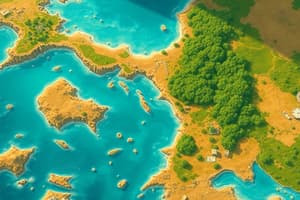
- Lagoon: Shallow seawater body, often isolated by a barrier, or found inside an atoll.
- Longshore Bar: Accumulation of sand parallel to the shore due to wave action.
- Longshore Current: Current running parallel to shore caused by angled wave approach.
- Longshore Drift: Sediment movement along the shoreline, driven by waves.
- Longshore Trough: Submerged area parallel to shore created by returning wave water.
- Low-Energy Coast: Coast occasionally subjected to large wave action.
- Low-Tide Terrace: Hard-packed beach area where wave energy is expended, crucial for significant sand movement.
- Moraine: Ridge of sediment deposited by glacial activity.
- Partially Mixed Estuary: Estuary with seawater inflow under a surface layer of fresh water.
- Reverse Estuary: Estuary where increasing salinity occurs from ocean to freshwater areas due to evaporation.
- Rip Current: Strong surface current moving seaward, caused by excess water in longshore troughs.
- Salt Wedge Estuary: Estuary where rapid river flow leads to an inclined seawater wedge at the mouth.
- Sand Spit: Accumulation of sand extending from a headland, often curling at the end.
- Sand Bar: Submerged/exposed sand accumulation due to wave effects.
- Sea Cave: Cave at sea level in a cliff formed by marine erosion.
- Sea Cliff: Cliff marking the limit of marine erosion on an erosional coast.
- Sea Island: Island once joined to the mainland, now isolated by rising sea levels.
- Shore: Boundary where land meets ocean, marking high tide limits on nautical maps.
- Supralittoral Zone: Area above the highest tides, not part of the ocean bottom.
- Swash: Water from waves washing up onto the beach.
- Tombolo: Above-water sand formation connecting an offshore feature to the mainland.
- Wave-Cut Platform: Flat terrace on erosional coasts indicating the limit of marine erosion.
- Well-Mixed Estuary: Estuary where tidal mixing regularly combines fresh and saltwater.
Studying That Suits You
Use AI to generate personalized quizzes and flashcards to suit your learning preferences.