Podcast
Questions and Answers
Which theme of geography focuses on the study of how people change their habits to suit their environment?
Which theme of geography focuses on the study of how people change their habits to suit their environment?
- Movement
- Location
- Human-Environment Interaction (correct)
- Region
Which of the following best describes the concept of relative location?
Which of the following best describes the concept of relative location?
- The population of a specific location
- Physical characteristics of a place
- Describing a place in comparison to another place (correct)
- The exact coordinates of a place on Earth
A map showing the boundaries of countries, states, and cities is best described as what type of map?
A map showing the boundaries of countries, states, and cities is best described as what type of map?
- Thematic Map
- Political Map (correct)
- Climate Map
- Physical Map
What geographical factor most directly influences the development of harbor towns?
What geographical factor most directly influences the development of harbor towns?
Which of the following trade activities best exemplifies international trade?
Which of the following trade activities best exemplifies international trade?
What is a significant challenge associated with the barter system of trade?
What is a significant challenge associated with the barter system of trade?
Which factor most directly contributes to the creation of 'rain shadows' near mountain ranges?
Which factor most directly contributes to the creation of 'rain shadows' near mountain ranges?
Which of the following describes a key feature of plains as a landform?
Which of the following describes a key feature of plains as a landform?
What is the primary way plateaus are formed according to the provided information?
What is the primary way plateaus are formed according to the provided information?
Which of the following factors is most influential in determining areas of dense versus sparse population?
Which of the following factors is most influential in determining areas of dense versus sparse population?
What is the function of a compass rose on a map?
What is the function of a compass rose on a map?
How did the Industrial Revolution impact global trade patterns?
How did the Industrial Revolution impact global trade patterns?
According to the information, what is a potential negative impact of global trade?
According to the information, what is a potential negative impact of global trade?
What geographic factor can pose a challenge to trade routes?
What geographic factor can pose a challenge to trade routes?
What aspect of South Africa's economy is supported by its suitable climate?
What aspect of South Africa's economy is supported by its suitable climate?
Which of the following best describes how supply and demand affect trade?
Which of the following best describes how supply and demand affect trade?
What is a key difference between the Silk Road and modern e-commerce trade systems?
What is a key difference between the Silk Road and modern e-commerce trade systems?
What outcome can occur in the short term if a natural disaster blocks a key trade route?
What outcome can occur in the short term if a natural disaster blocks a key trade route?
What does the concept of 'sustainability' mean in the context of global trade?
What does the concept of 'sustainability' mean in the context of global trade?
Choose the option that is a TRUE statement.
Choose the option that is a TRUE statement.
Flashcards
Absolute Location
Absolute Location
The exact spot of a place using coordinates (latitude and longitude).
Relative Location
Relative Location
Where a place is in comparison to other places.
Place
Place
Physical and human characteristics that make a location unique.
Physical Characteristics
Physical Characteristics
Signup and view all the flashcards
Human Characteristics
Human Characteristics
Signup and view all the flashcards
Region
Region
Signup and view all the flashcards
Formal Regions
Formal Regions
Signup and view all the flashcards
Functional Regions
Functional Regions
Signup and view all the flashcards
Vernacular Regions
Vernacular Regions
Signup and view all the flashcards
Movement
Movement
Signup and view all the flashcards
People Movement (Migration)
People Movement (Migration)
Signup and view all the flashcards
Goods Movement (Trade)
Goods Movement (Trade)
Signup and view all the flashcards
Ideas Movement (Cultural Exchange)
Ideas Movement (Cultural Exchange)
Signup and view all the flashcards
Mountains
Mountains
Signup and view all the flashcards
Valleys
Valleys
Signup and view all the flashcards
Plains
Plains
Signup and view all the flashcards
Plateaus
Plateaus
Signup and view all the flashcards
Deserts
Deserts
Signup and view all the flashcards
Key or Legend (Maps)
Key or Legend (Maps)
Signup and view all the flashcards
Scale (Maps)
Scale (Maps)
Signup and view all the flashcards
Study Notes
- Geography studies the Earth, its features, environments, and how people connect with their surroundings.
- Five themes help in understanding geography: location, place, human-environment interaction, movement, and region.
Location
- Tells where something is on Earth.
- Absolute: The exact spot of a place, given in coordinates (latitude and longitude.)
- Example: The Eiffel Tower in Paris is around 48.8584° N latitude and 2.2941° E longitude.
- Relative: Describes where a place is compared to other places.
- Example: The United States is south of Canada.
- The Great Wall of China is in northern China.
- The Amazon Rainforest is mostly in Brazil, in South America.
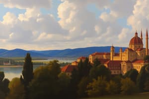
Place
- Describes the physical and human features that make a location special.
- Physical Characteristics: Landforms, Climate, and Vegetation.
- Human Characteristics: Culture, Population, and Infrastructure.
- The Sahara Desert is known for its huge sand dunes and hot temperatures.
- Tokyo, Japan, is famous for its busy city life and advanced technology.
Human-Environment Interaction
- Looks at how people interact with their environment and how the environment affects them.
- Adaptation: People change their habits based on the environment.
- Example: People in cold places wear warm clothes.
- Modification: People change their environment.
- Example: Building dams to manage water flow.
- Dependence: People rely on the environment for resources like water, food, and shelter.
- The Dutch have built dikes to keep their land safe from flooding.
- Farmers plant crops based on the seasons.
Movement
- Deals with how people, goods, and ideas travel from one place to another.
- People: Migration is when people move to a new place for jobs or better living conditions.
- Goods: Trade is when countries exchange products, like Brazil exporting coffee.
- Ideas: Cultural exchange happens when music and art spread from one place to another.
- The Silk Road was an ancient trade route connecting Asia and Europe.
- Social media helps ideas spread quickly around the world.
Region
- An area defined by certain features that make it different from other areas.
- Formal Regions: Have official boundaries, like countries or states.
- Example: California.
- Functional Regions: Defined by a specific function or activity.
- Example: New York City.
- Vernacular Regions: Based on people's feelings or thoughts.
- Example: "The South" in the United States.
- The Amazon Basin is a formal region known for its rainforest.
- The Rust Belt in the U.S. is a vernacular region known for its old factories and changing economies.
- Learning about the five themes of geography helps one understand the world better.
- By looking at location, place, human-environment interaction, movement, and region, we can see how people and places connect and affect each other.
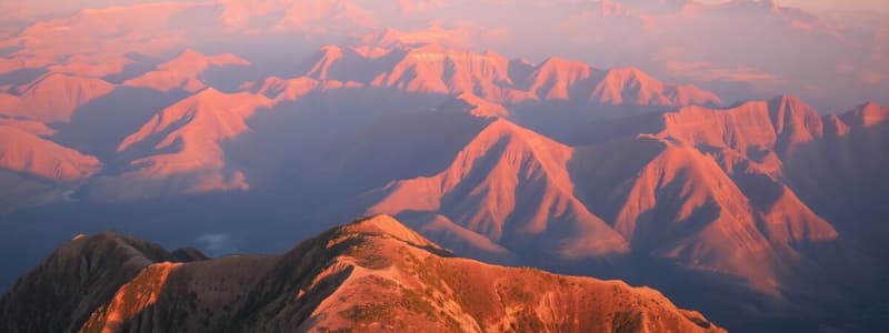
Landforms
- Landforms are the natural features of the Earth's surface, created by natural processes like erosion, weathering, tectonic activity, and deposition.
- Mountains: High areas of land with steep sides, formed by tectonic activity.
- Example (South Africa): The Drakensberg Mountains, over 3,000 meters high.
- Example (Global): The Himalayas in Asia, home to Mount Everest, the Andes in South America, and the Rocky Mountains in North America.
- Valleys: Low areas of land between hills or mountains, often with rivers or streams.
- Example (South Africa): The Blyde River Canyon, which is more than 700 meters deep.
- Plains are large, flat areas of land, usually good for farming.
- Plateaus: Flat areas of land that are much higher than the land around them, called "tablelands."
- Deserts: Dry areas with little rain and few plants, often with high temperatures.
Importance of Landforms
- Landforms affect climate and weather.
- Mountains can block rain.
- Different landforms affect how people live and work.
Mapwork
- The practice of studying and understanding maps to learn about different places and features on Earth.
- It is important for knowing how the world is arranged.
- Maps are important tools that visually represent information about the Earth’s surface.
- Political Maps: Show the boundaries of countries, states, cities, and towns.
- Physical Maps: Highlight natural features of the land.
- Thematic Maps: Focus on specific topics.
- Climate maps show rainfall patterns.
- Other thematic maps: population distribution, resources
- Transportation maps show roads and railways
- Land-use maps indicate areas for farming, forests, and cities.
Reasons for the Location of Settlements
- Industrial towns: Factories are built where resources like coal are nearby.
- Mining towns: Mines provide work and attract people.
- Harbour towns: Safe bays allow for building harbours.
- Fishing towns: Lots of fish available provide a living.
- Laws in South Africa influenced where people lived before 1994.
- Today laws still prevent people from living in certain places like protected areas.
Rural vs. Urban Areas
- Rural Areas: Areas where people mostly live on farms or in farming areas, sparsely populated with open spaces.
- Urban Areas: Cities or big towns, densely populated with many buildings, factories, and businesses.
- Three key reasons why some areas are more densely populated include the influence of climate, access to fresh water, and mineral resources.
Map Elements
- Compass Rose: Shows directions like North, South, East, and West.
- Key or Legend: Explains the symbols and colours on the map.
- Scale: Shows the relationship between distances on the map and real distances on the ground.
- Latitude and Longitude: A grid that helps locate specific points on Earth
- Latitude: Imaginary lines that run east to west, measuring distance from the equator.
- Longitude: Lines that run from north to south, measuring distance from the Prime Meridian.
Importance of Mapwork
- Helps improve understanding of the world.
- Assists in navigation and planning.
- Helps in analyzing various data across different regions.
- Aids decision-making and promotes awareness.
Trade
- Trade involves the exchange of goods and services between people, regions, or countries. It is important for the economy and meets the needs of communities and people.
Key Types of Trade
- Local Trade: Happens within a specific community or region.
- National Trade: Takes place within a country connecting different areas.
- International Trade: Goods and services exchange between different countries, including what is sold (exports) and what is bought (imports).
Importance of Trade
- It makes economic growth faster and creates job opportunities.
- Helps industries at every level, leads to living standards improvement.
- Access to Goods/Services: People enjoy products that may not be available in their own country and offers higher quality products.
- Strengthens between countries: Can lead to cultural and technological exchanges
- In South Africa, the country ships gold and diamonds known for its high quality, also ships citrus fruit
Factors Influencing Trade
- Geography: Natural features and economic elements influence trade.
- For example, mountains could block key routes of travel.
- During the Industrial Revolution, goods became cheaper as well as easier to manufacture.
- Economic factors: These include money demand for production, the use to of technology.
Key Concepts for Understanding Trade
- Globalization: Process where trades happen between countries through technology Supply chain: The many steps of a getting product from point A to point B Disruption: An event that slows are even stops key travel.
- Sustainability: Resources used in a way that do not harm the environment.
Trade Systems
-Ancient Times: development of the Silk Road. -Development of the Panama: opening of Panama Canal -21st Century: Rise of e-commerce platforms
Studying That Suits You
Use AI to generate personalized quizzes and flashcards to suit your learning preferences.