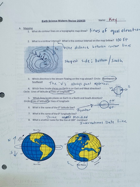
What do contour lines on a topographic map show? What is a contour interval? What direction is the stream flowing on the map above? Which lines locate places on Earth in an East an... What do contour lines on a topographic map show? What is a contour interval? What direction is the stream flowing on the map above? Which lines locate places on Earth in an East and West direction? Which lines locate places on Earth in a North and South direction? What is the name of the latitude line? What is the name of the longitude line? What is another name for the line at 180° meridian?
Understand the Problem
The question relates to topographic maps and geographical concepts, including contour lines, directions of river flow, and lines of latitude and longitude.
Answer
Contour lines show equal elevation. Contour interval is vertical distance between lines. Streams flow opposite to 'V's in contours. Latitude lines run east-west; longitude lines run north-south. Equator: latitude; Prime Meridian: longitude; 180° meridian: International Date Line.
Contour lines on a topographic map show lines of equal elevation. A contour interval is the vertical distance between contour lines. Streams flow downhill in the opposite direction of contour line 'V's. Lines of latitude run east-west, lines of longitude run north-south. The Equator is a latitude line, the Prime Meridian is a longitude line, and the 180° meridian is the International Date Line.
Answer for screen readers
Contour lines on a topographic map show lines of equal elevation. A contour interval is the vertical distance between contour lines. Streams flow downhill in the opposite direction of contour line 'V's. Lines of latitude run east-west, lines of longitude run north-south. The Equator is a latitude line, the Prime Meridian is a longitude line, and the 180° meridian is the International Date Line.
More Information
Contour maps are crucial for geologists and hikers, helping them understand the terrain's relief and elevation changes. The Equator and the Prime Meridian are key reference lines used for navigation and time zones.
Tips
Confusing contour lines with elevation numbers can lead to misinterpretation. Always check the legend for the contour interval to understand elevation changes.
Sources
- 5.5 Contour Lines and Intervals - NWCG - nwcg.gov
- Overview of Topographic Maps – Laboratory Manual for Earth Science - pressbooks.bccampus.ca
- How to Read a Topographic Map: The Complete Guide - meredithfontana.com
AI-generated content may contain errors. Please verify critical information