Podcast
Questions and Answers
Weather charts are only useful for meteorologists.
Weather charts are only useful for meteorologists.
False (B)
Surface charts primarily focus on atmospheric conditions in the upper atmosphere.
Surface charts primarily focus on atmospheric conditions in the upper atmosphere.
False (B)
Isotherms on upper air charts represent humidity values.
Isotherms on upper air charts represent humidity values.
False (B)
Pressure tendencies on surface charts are represented by arrows pointing towards decreasing pressure.
Pressure tendencies on surface charts are represented by arrows pointing towards decreasing pressure.
Satellite imagery provides a close-up view of weather systems over small geographical areas.
Satellite imagery provides a close-up view of weather systems over small geographical areas.
Isentropes on upper air charts show changes in potential temperature.
Isentropes on upper air charts show changes in potential temperature.
Lines on weather charts represent various meteorological variables such as temperature.
Lines on weather charts represent various meteorological variables such as temperature.
Symbols like wind barbs indicate wind speed based on the shape of their arrowheads.
Symbols like wind barbs indicate wind speed based on the shape of their arrowheads.
Color red on weather charts usually represents low temperatures.
Color red on weather charts usually represents low temperatures.
Hatching on weather charts signifies the type of cloud formations.
Hatching on weather charts signifies the type of cloud formations.
Weather charts follow a standard layout with south oriented towards the top.
Weather charts follow a standard layout with south oriented towards the top.
Advancements in technology have led to the digitalization of weather data representation.
Advancements in technology have led to the digitalization of weather data representation.
Flashcards are hidden until you start studying
Study Notes
Weather Charts: Understanding the Visual Representation of Atmospheric Conditions
Weather charts refer to visual representations of atmospheric conditions, providing valuable insights into various meteorological variables. These charts serve as crucial tools for meteorologists and weather enthusiasts alike to understand and predict weather patterns. They convey essential information regarding temperature, humidity, wind speed, and other elements that contribute to overall weather behavior.
Types of Weather Charts
There are primarily three types of weather charts:
Upper Air Charts
Upper air charts depict the vertical distribution of temperature, humidity, and winds aloft. Isotherms indicate temperature levels, while hygroids represent humidity values. Isentropes show changes in potential temperature along with isotachs representing wind speed.
Surface Charts
Surface charts focus on ground-level conditions, including temperature, dew point, sea level pressure, and wind direction. Pressure tendencies are also represented by arrows pointing towards increasing pressure.
Satellite Imagery
Satellite imagery provides a bird's eye view of weather systems over vast geographical areas. These images can capture cloud formations and their movement patterns.
Reading Weather Charts
Interpreting weather charts requires a basic understanding of several key elements:
Lines and Symbols
Lines on weather charts represent various meteorological variables such as wind speed (isotachs) or temperature (isotherms). Symbols like wind barbs indicate wind direction based on the shape of their arrowheads. Other symbols depict cloud types (stratus, cirrus), precipitation areas (filled circles for rain, open circles for snow), and non-isolated weather phenomena.
Color Coding
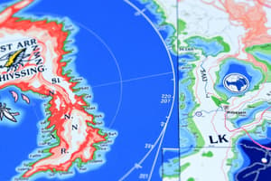
Colors are often used to differentiate between different atmospheric conditions. For instance, red may indicate high temperatures while blue represents low temperatures. Similarly, hatching can denote precipitation intensity.
Layout and Scale
Weather charts typically follow a standard layout with north oriented towards the top. Scales help determine the magnitude of variables like temperature or wind speed.
History and Evolution
Historically, weather charts were hand-drawn by skilled meteorologists using specialized equipment like penplotters and fax machines. However, advancements in technology led to digitalization of weather data representation. Today, computer models generate detailed weather charts that update continuously, providing real-time insights into atmospheric conditions.
Studying That Suits You
Use AI to generate personalized quizzes and flashcards to suit your learning preferences.